|
|
1. UC-win/Road Ver.10.1
2. Overseas
Training and Seminars
|
| 1. UC-win/Road Ver.10.1 |
| UC-win/Road Version10.1 provides even more customer improvements to our
software. One such development is the ability to compress project data
and hence reducing file size significantly. These new features and functions
along with others are outlined below... |
| Improved texture formatting |
 |
 Figure 1 PNG file display result Figure 1 PNG file display result |
It is now possible in Ver 10.1 to import PNG files so they can be used
for texturing your 3D model. You can also superimpose the PNG files within
the image display of any scenario.
Also when saving project data, the compression function of textures (compressed and uncompressed can be selected) has now been added. The comparison of the performance and the size in the case of the compressed and uncompressed textures is shown in table 1. The time for saving and reading will be a little longer, but the file size has been greatly reduced.
| File name |
Uncompressed |
Compressed |
| Save |
Reading time |
Data size |
Save |
Reading time |
Data size |
| Mt Parkway |
19 sec |
34 sec |
368MB |
22 sec |
33 sec |
146MB |
| City Design |
79 sec |
65 sec |
926MB |
89 sec |
71 sec |
510MB |
| Highway |
25 sec |
38 sec |
740MB |
35 sec |
44 sec |
378MB |
| Table 1 Comparison of texture compression time and file size |
|
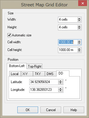
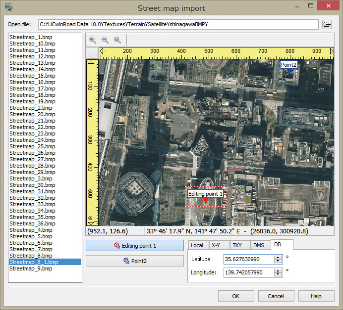
| Improved method of arranging street map images within the 3D environment |
The previous method used to arrange street maps was to define the width
(east and west) and height (north and south) of the division by designating
the origin (bottom left) in the local coordinate system or in the rectangular
plane. Ver10.1 has added the following functions...
- The method of defining the map by designating the coordinates at the left
bottom and right top of the division
- Ability to use the latitude and longitude (designate by dddmmss.sss, decimal
numbers)
 |
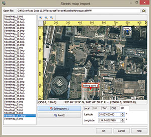 |
| Figure 2 Latitude and longitude, street map arranged by designating
two origins |
Together with the method of selecting the image after defining the division, arrangement in the arbitrary position is supported by defining the two coordinates on the image. By this, when inputting the satellite photograph from a map such as Google maps, it can be easily pasted just by searching the two arbitrary latitude and longitude points. (Please check the licensing guidelines, etc., when using satellite photographs from the Internet)
|
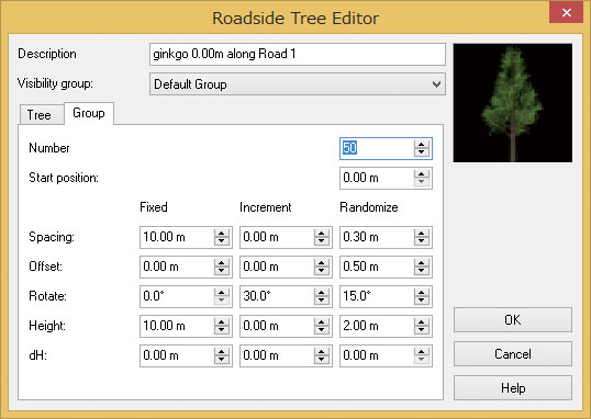
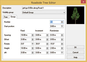
| Group arrangement of roadside objects |
The automatic grouping of roadside objects such as traffic signs, 3D models, trees, markings, etc has been improved.
For example, by adding a 'randomness' to the height and also to the direction the row of trees can be automatically adjusted so they will appear as natural as possible thus constructing a more realistic VR space. This is a useful tool in saving time when creating your 3D environment.
 |
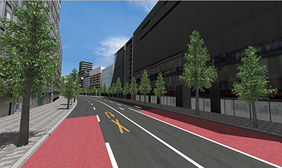 |
| Figure 3 The roadside object setting screen and the result of
the group arrangement |
|
| In regard to the import and export of LandXML, Ver10.1 now supports the
'relaxing curves' of railway alignments (cubic parabolic curves and sine
half wave length curves). With this data exchange with other software packages
now becomes possible. |
| A license managing library has been introduced; also the license manager
screen has been renewed and updated for use with the setting of the Web
authentication codes. |
Future developments and planned improvements include the improvement of the driving diagnosis plug-in, the bicycle simulation plug-in and the head sensor plug-in (real time cooperation of 3D stereo and the direction of the head).
In addition, we are planning to release a suite version of UC-win/Road
and for users of the UC-1 engineer suite we can provide it at a bundle
price. |
| (Up&Coming '15 New Year Issue) |
|
| 2. Overseas Seminars and Exhibition |
Exhibition
| Date |
Exhibition Name |
Location |
| Feb. 11 |
Redas Engineering |
Milan, Italy |
| Feb. 18 - 20 |
IRITS International Railway Summit |
Barcelona, Spain |
| Mar. 30 - Apr. 1 |
AWRA (xpswmm) |
LA USA |
| Apr. 19 - 22 |
GIS-T Symposium |
Des Moines, USA |
| May 13 - 15 |
AASHTO Spring Meet |
Cheyenne, USA |
| Jun. 5 - 6 |
Modelling World |
London, UK |
| Jun. 15 - 18 |
Automotive Testing Expo |
Stuttgart, Germany |
| Sep. 20 - 23 |
Innotrans (Rail) |
Berlin, Germany |
| Oct. 5 - 9 |
ITS World Congress |
Bordeaux, France |
| Nov. 18 - 20 |
Forum8 Design Festival |
Tokyo Japan |
For
more information and applications, please email us at
mailto : office@forum8.com
Gross circulation: 7,590
To subscribe this page, go to http://www.forum8.co.jp/english/p-mail-e.htm
If you would like to unsubscribe from our newsletters, please include
"Unsubscribe"
in the subject title of your email and send it back to us.
Thank you for your continued support.
FORUM8 Co., Ltd. mailto: forum8@forum8.co.jp
Shinagawa Intercity A-21F, 2-15-1 Konan, Minato-ku, Tokyo
Postal code: 108-6021
Phone: (+81)3-6894-1888
FAX: (+81)03-6894-3888
http://www.forum8.co.jp/english/index.html |
|