 |
Vol.4 2011. 3. |
The latest news of 3D drawing service / 3D modeling service / 3D scan VR modeling service
"Student BIM&VR Design Contest" the competition of the advanced architectural civil design will be held!
| Bridge Design Award, Architectural City Design Award Extra prize:1,000,000 Yen of Scholarship |
FORUM8 will hold the 1st Student BIM&VR Design Contest, competition of the advanced architectural and civil design using BIM&VR. The information of application is described below. The award will be announced in November 4, 2011 and the awarded works are exhibited during FORUM8 Design Festival 2011 -3Days (November 15-17, 2011/ Shinagawa Front Building, Tokyo). Through this contest, it is expected the new ideas and technology using BIM&VR will be discovered.
 |
Theme: Pedestrian bridge design
|
Case Study of 3D Drawing Service
"3D representation of the damaged points/maintenance condition. Use for maintenance management process."
| Case Study of 3D Drawing Service |
It shows how to represent the damaged parts and the maintenance condition of the existing structures in 3D using Allplan with case studies of 3D drawing service.
 |
| 3D CAD with BIM, Allplan |
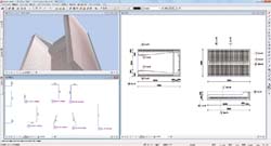
3D Modeling Flow
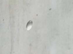
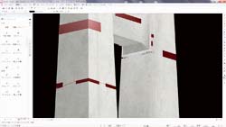
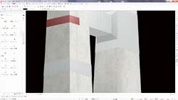
| The structure outline is created through new model creation. In addition,
if there are the defects in the concrete, the damaged model (Figure1) is
separately created and they are pasted on the appropriate parts as texture
with the reference pictures. It allows the representation of the exposed
bar including the defects and honeycomb (Figure2a/3a). Next, represention of the maintenance parts. The maintenance image models are separately created on the damaged parts and they are pasted on the damaged parts (Figure2b/3b). |
|
 |
 |
|
 |
 |
|
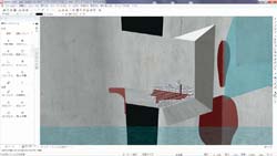
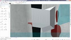
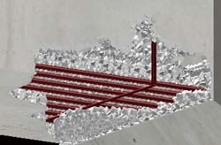
Realistic Representation with 3D Model
The defective area and post-maintenance of 3D model structures are shown below. The each bar is separately modeled and arranged in the exposed part of bars. The reinforcement arrangement and covers can be represented based on the existing final completion. The frames are represented by overlaying the models such as small stone grains one by one (Figure4).
 |
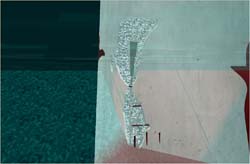
The color of body, reinforcement and frame can be highlighted in 3D model to represent clearly as well as the representation by the realistic color. In addition, if the structure is under water, it can be represented with water transparent by creating the model and changing its transmission factor. The underground model can be represented by developing it (Figure5/6).
 |
 |
|
Estimation Samples of 3D Scan Modeling Service
"3D Scan Modeling Service" provides the realistic 3D VR data by importing the point cloud data which is measured with 3D scanner into UC-win/Road.
| Process and estimation of point cloud measurement |
It requirs a minimum of two points per 100m of road according to the surrounding condition such as terrain data. It takes one hour for preparation, measurement, moving to the next survey point. If there are public reference points, the same measurement type is required. When the measurement accuracy is 20m ahead and the point clouds with 1.5cm of space, the total point clouds are around 4,000,000 points across 100m section.
To measure on the road, it is necessary to submit the permit application to the police department a few days in advance. It occasionally requires an application for using the public survey reference point. We also provide this application service.
| 3D Scan Modeling | |
| The 300m of standard road in the urban area is measured by 3D scan. It
includes the measurement of a public reference point to obtain the coordinate
data. The measurement is performed by the group of two and a traffic control person, including the measurement preparation and post-process of the measured data. |
|
| Measurement range | 300m |
| Measurement of public reference point | 1 spot |
| Measurement day | 1 day |
| Measurement preparation, post-process of point cloud data |
2 people for each, total about 0.5 day |
| Total | 133,008Yen |
| 3D VR Modeling | |
| Represents the measured range of point cloud data. Adjusts the space based on the point cloud (UC-win/Road Estimation, excellent B level). Arranges the roads, 20 buildings along the road, signs, two types of 3D tress, and power poles. |
|
| Process of terrain, linear, 3D model, texture | 300m (UC-win/Road Standard Estimation) |
| Modeling of buildings, signs, and plants | Creates 20 buildings, 5 types of signs, and 2 types of 3D trees. |
| Total | 358,207Yen |
Student BIM Software Modeling Contest in China
"The 2nd National University Thsware Cup" will be held in May.
FORUM8 will co-organize the competition of BIM software modeling for students "The 2nd National Thsware Cup" with our dealer Thsware (Shenzhen Tsinghua Sware Software Hi-Tech Co., Ltd) in Shenzhen, China.
| Many applicants for the new "VR Section" |
Following the 1st Thsware Cup, we accept the application from students who major in architecture, civil engineering, construction management, construction quantity survey, architectural environment, facility process, energy-saving design in university, college and professional school and the new theme "VR" is added this year. The participants are applying in a group of two to five (from 1 to 5 educators) and the multiple teams can apply from each academic institution.
There are eight application sections : Architectural design software / Construction design and constructional analysis software / Eco design and solar analysis software / Facility design and insulation load software / 3D quantity survey software / Construction quantity survey software / PM (Project Management) and bidding support software / construction process and VR simulation system. A team can participate in maximum 8 sections.
The application and the pre-judgement have started on January 1st, 2011. The application deadline is March 18, and currently more than 100 universities have applied at the end of January and more than 40 have applied for VR section. The works are applied via Internet and the works for final match are selected by public voting and the judge's evaluation based on the judgement rule. To judge fairly, each judge takes charge of the area to which they are assigned.
The final match is scheduled to be held on March 7 and 8, 2011. Each team needs to submit the answers of two provided tasks within the limited time and they are scored by THS-ACS system. This system is the real-time scoring system developed by Thsware for this contest and it features the fairness and transparency. Through this event, it is expected for the students from all of China to experience the design with BIM&VR knowledge and technology.
[Application URL] : http://www.thsware.com/bim/
The final match in the 1st contest was held in April 17, 2010 in Qingdao Nongye University, China. The photo shows the excited students in the final match. This event was reported in the local TV news. |
 |
 |
||||
| BACK | LIST | NEXT |

