●Date : Tue 8 July - Fri 11 July, 2014
●Venue : Hilton Hawaiian Village Waikiki Beach Resort |
(Up&Coming Fall Issue, 2014) |

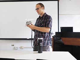
| The International VR Symposium The 5th Summer Workshop and The State of the Arts Technology in Expresion Session were held at Hilton Hawaiian Village Waikiki Beach Resort in Honolulu, Hawaii from 8 July - 11 July, 2014. |
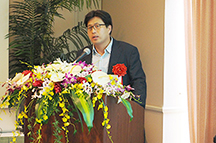
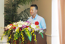
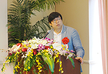
Following the greeting from Mr. Toshiro Kawamura who has been a special
advisor of FORUM8, Mr. Theodore M. H. Huang who is an honorary director of The Chinese National
Association of Industry and Commerce, gave a greeting as a special guest
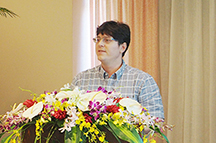
and Yuji Ito, FORUM8 president gave an opening greeting.
The World 16 members who are internationally acclaimed researchers using
UC-win/Road and judges for FORUM8's competitions were also invited. |
 |
| Day1 |
Tue 8 July |
Lectures
by users who invited as special users, opening message (Yoshihiro
Kobayashi, associate professor of Arizona State University),
Pre-workshop, Sessions for The Association of State of the Art
Technologies in Visual Expression, Summer Workshop Session, VDWC/CPWC
Session / First Round Evaluation etc. |
| Day2 |
Wed 9 July |
Technical Tour 1 (Hawaii University), Technical Tour 2 (Tetsuo Harano Tunnel),
World16 Workshop etc. |
| Day3 |
Thu 10 July |
World16 Workshop etc. |
| Day4 |
Fri 11 July |
A work for Projection Mapping created by World16 will be presented on screen |
|
 |
 |
 |
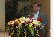
| ■Mr. Toshiro Kawamura (Left), Mr. Theodore M. H. Huang (Middle), Yuji Ito (Right) |

The past award winners for "3D VR Simulation Contest" held by
FORUM8 gave their lectures about the project progress after their receiving
awards under the theme of "The case study via UC-win/Road and the
subsequent development". Moreover the FORUM8's excellent dealers who
were invited reported the trends in each country under the theme of "IT
business operation and its trend".
■Users invited as special guests
Prof. Shigenari Tanaka, Faculty of INFORMATICS, Kansai University
"Proposal of underground installation of Hanshin expressway and improved
city using VR" |
| In
addition to the research and development of a standard file format to
be used when exchanging different types of 2D CAD data (namely the
"SXF"), and CAD model standard, he was responsible for the development
of a method to make a 3D model from a 2D drawing and Japan's first 3D
CAD engine. Thanks to these new developments, the circulation of
information for the life cycle of a construction project is now
possible. In particular, this life cycle is the process from measuring
the terrain and designing a 3D model of the measured terrain, to using
that model for the construction management and then uploading the
work progress to GIS (Geographical Information System). |
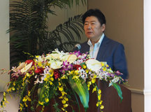
■Prof. Shigenori Tanaka |
| Recently, the creation of a river's surface model and profile became possible by the following procedure: Collect the point cloud data from the river to capture its shape using an aerial laser scanner or the aerial photogrammetry technique put into practice by UAV (Unmanned Aerial Vehicle), and create the river's surface model and profile based on the point cloud. By using these technologies, the shape of a river's cross section before and after a disaster can be compared by looking at its profiles in two different points in time. This would help speed up the recovery work. |
Mr. Hidenori Goto and Mr. Shogo Umeda, ORIENTAL CONSULTANTS Co., Ltd.
"VR Data for Ohashi Junction of Metropolitan Expressway"
|
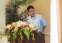
■Mr. Hidenori Goto |
| Due to the reason Ohashi junction of metropolitan expressway has the limited
site, the difference in height 70m between the Shinjuku line and the raised
expressway Route 3 of Shibuya line of Central Circular Route are connected
with a two-turn loop. This year, Central Circula Route is planned to be
re-expanded and additional Shinagawa line will be open, therefore the the
branch points on it will be increased. To induce drivers smoothly, the
design was verified by the color pavement with red and blue, modeling it
in UC-win.Road and using a driving simulator. Moreover the evacuation route,
sign boards and guide boards etc. were modelled in UC-win/Road and they
have been used for optimization of evacuation signs and explanation of
evacuation routes. This wil be published on HP. |
Prof. Lee Dongmin of Seoul National University
"Application of VR simulation for new type of road structures" |
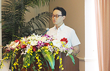
■Prof. Lee Dongmin |
| In "3D VR Simulation Contest in 2013", he submitted his data
about the new type of road "2+1 lane road" in which the center
line was used as the passing lane for either inbound or outbound according
to the site (Total of 3 lines of road would be constructed.). This could
be the low-cost and effective road, however, the length of boundary where
inbound and outbound are switched etc. have to be verified very carefully.
Therefore, "2+1 lane road" was modelled in UC-win/Road and the
driving characteristic features of various kinds of examinees including
seniors were quantitatively verified. In the future, he will research about
the visibility at night and effects on pedestrians etc. and plan to submit
the part of the results to 3D VR Simulation Contest again. |
■Excellent dealers
| Oya Kinoshita, Iwasaki CO., LTD. |
■Mr. Oya Kinoshita |
Iwasaki CO., LTD. has 12 sales offices in Hokkaido and recently the branch
office in Tokyo opened. What they focus on the most is now CIM (Construction
Information Modeling).
In Hokkaido, VR application has been widely used for the past 5 - 6 years.
Various kinds of simulation has been run by precisely modeling the site
in 3D environment including slope construction, efficient operation of
damp aimed at CO2 emissions reduction etc., noise of heavy machines etc.
The cross sections of slope in snow via 3D laser scanner have been also
created. There is another case example that the data of sensors and measuring
equipments have been linked with CIM data in operation and maintenance
field. |
| Ms. Anita Byrnes, FORUM8 AU PTY Ltd |
■Ms. Anita Byrnes |
In Australia, the investments to infrastructure including roads and railways
have been increased and there are a lot of business chances now.
As the UC-win/Road users, we have customers of construction companies,
consultants, government and universities etc. Driving simulators are used
for research about drink-driving and training for drivers (ex. for the
drivers who unload or load imported and exported vehicles from car carrier
ship, data of QUBE in Australia).
In addition to this, UC-win/Road is used for driving education before young
peoples get drivers' licenses as well. |
| Mr. Kim Dohoon, FORUM8 KOREA |
■Mr. Kim Dohoon |
FORUM8 KOREA sells UC-win/Road, driving simulators, EXODUS and DesignBuilder.
UC-win/Road is used for verifying the position of signs and tunnels or
line shape of highway newly built by Korea Expressway Corporation as well
as for developing devices to improve security for trackwork by Korean Rail
Research Institute.
The targets in Korea market in the future will be the research of traffic
and drivers' behavior, development of autonomous cars and head-up display
or driving simulators etc. |

■Sessions for The Association of State of the Art Technologies in Visual Expression
Mr. Karl Kim (National Disaster Preparedness Training Center/USA)
"Creation of a Hazard Map that considers the socioeconomic aspect" |
■Mr. Karl Kim |
| National Disaster Preparedness Training Center in Hawaii University is
carrying out research and development regarding disaster prevention based
on the Hawaii-specific geographical and cultural background. The 4 kinds
of hazard map of flood caused by sea-level rise, storm, tsunami and 500-year
river flood have been made on GIS. At the same time, an evacuation simulation
that takes into consideration the socioeconomic aspect of the society i.e.
simulation that considers the elderly, children, disabled and non-English-speaking
people and those that do not own cars, is run. In the event of any one
of these kinds of disaster, evacuation directions are given out to inhabitants
through various types of medium including TV, mobile phones, Internet,
sirens etc. from IPAWS (The Integrated Public Alert and Warning System).
|
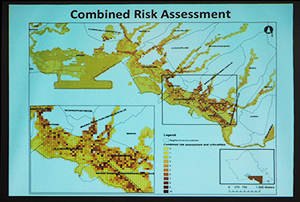
■Socioeconomy-related Hazard Map |
Mr. Goro Sulijoadikusumo (State of Hawaii, Department of Transportation
/ USA)
"The application of colored point cloud data in road management"
|
Hawaii DOT manages and maintains roads which have a total length of approximately 5,000 miles over a total of 6 islands. To help to manage and maintain such a large range of roads Hawaii DOT started recording the condition of these roads as “Photo-log images” via cameras mounted onboard a mobile data collection vehicle. They have been continuously improving the resolution of these images through the use of more and better cameras. They were initially using two 1280 x 1024 pixels cameras; and in 2011 three 3296 x 2472 pixels cameras.
In 2009 Hawaii DOT began using a mobile 3D laser scanner to measure and record 1,000 miles of roads throughout the island of Oahu. The point cloud data collected was huge, consisting of more than 200 billion points with a collective size of 630GB. |
■Mr. Goro Sulijoadikusumo |
| In collaboration with FORUM8, Hawaii DOT added color to the point cloud data collected, using pixel data from the photo-log images of the target roads and surrounding structures. This was achieved using the point-cloud Photo Processing Extension plug-in (PPE) developed by FORUM8. The colored point cloud data was then imported into VR-Design Studio (formerly known as UC-win/Road), FORUM8's real-time interactive 3D VR simulation and modeling software. A 3D VR simulation environment of the target area was built using the colored point cloud data along with shapefile information, terrain data and aerial ortho-photography, all of which were imported into VR-Design Studio. The result being to help take the DOT's highway management/maintenance program to the next level. |
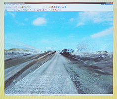
■The colored point cloud data
used for management of highway |
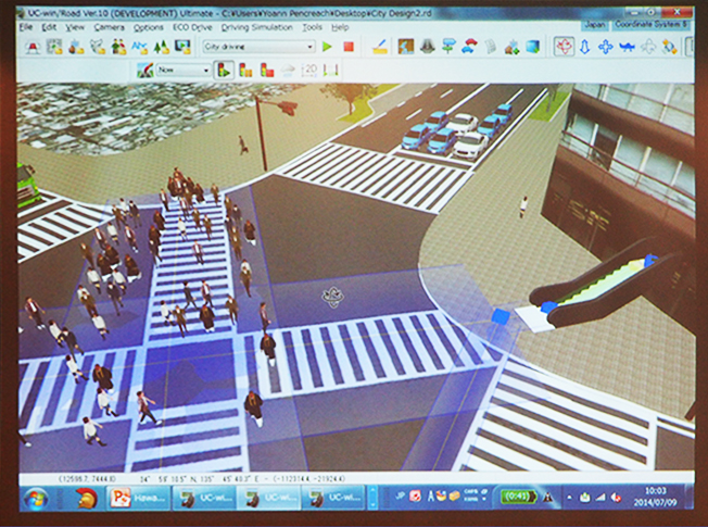
Yoann Pencreach, FORUM8 / Japan
"UC-win/Road keeping on evolving as CIM software" |
■Yoann Pencreach |
| In recently released UC-win/Road Ver.10, the speed, automatic control of
steering wheel and function related to the automated driving including
braking assist etc. in driving simulation functions were expanded. The
input/output function due to DWG file made the linkage with CAD more improved.
The crowd movement simulation has also been enhanced and "OD matrix"
in which the start position and destination can now be defined etc. As
for railway simulation function, the function to automatically calculate
the cant and to create the railroad switch have been added. Moreover the
linkage with Rhinoceros®, 64 bit supported and 3D data edit function
on VR-Cloud® etc., UC-win/Road has been kept on evolving as CIM software. |
■UC-win/Road keeping on evolving as CIM software |
■Summer Workshop Sessions
Associate Prof. Kostas Terzidis, Harvard University / USA
"Organic parking : The parking's booking system on cloud" |
■Associate Prof. Kostas Terzidis |
| When you go to the downtown area of a city by a car, you might have trouble
because you are not sure weather you can get a parking space or not. For
example, even if you made a reservation at a restaurant and prepared a
present for a wedding anniversary, you would not know if you would find a parking. He therefore
developed a system "Organic Parking". This is a system which
makes it possible to trade the usable time of a parking space interpersonally.
A trading system using parking space as a medium will be realized by cloud,
in a way that those who want to park will check the map, contact the seller
by chat, and change the places of the cars at the site. |
■User interface of Organic Parking |
Car
users stopping at a parking space will input the leaving time and the
selling price of the space through a smartphone, and that information
will be displayed on the map which also can be accessed by those
looking for a parking space who can then choose the most favorable
parking space from the ones available.
This system would help people
to book their parking space and solve many of the problems in
parking. He established the company "Organic Systems Inc." and is the
CEO of the company. |
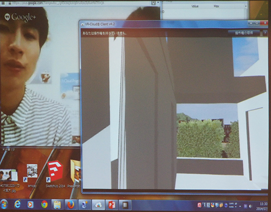
Associate Prof. Tomohiro Fukuda, Osaka University / Japan
"Real-time Collaboration to connect Hawaii and Osaka via VR-Cloud®" |
■Associate Prof. Tomohiro Fukuda |
| Using VR-Cloud® can make the design proceed with remote collaboration
between the designers who are geographically distant places. He gave an
example that even if you were in Hawaii, you would be able to go ahead
with designing via VR-Studio® while talking with studens in a laboratory
in Osaka University via TV conference system. For example, in case of a
project to build an apartment building at where an old house was demolished
in an urban area, they could verify the landscape through the window and
the appearance as well as the whole design of the building while confirming
and understanding the surrounding area and terrain in VR environment. |
In order to communicate with designers who are far apart each other, the function to manually draw on VR were really effective in addition to video conference and conference call.
It was effective especially to verify the space configuration and volume
of buildings in the initial stage of desgining. On top of that, it allows
to share the concrete images between designers and verify the design while
real-time communicating with each other. |

■Real-time Collaboration with Osaka University via VR-Cloud® |
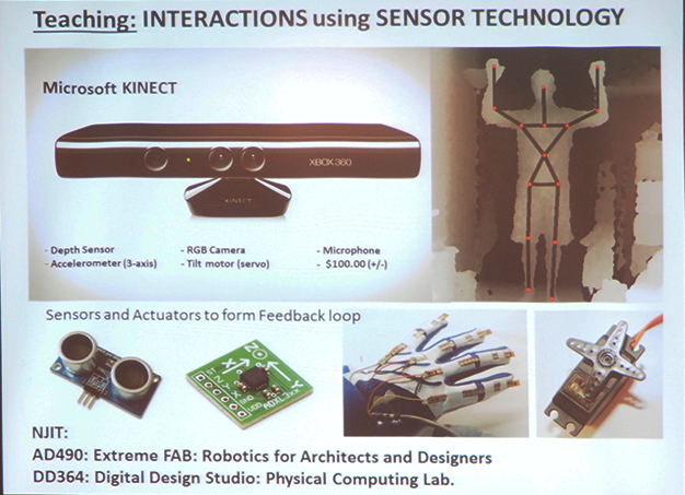
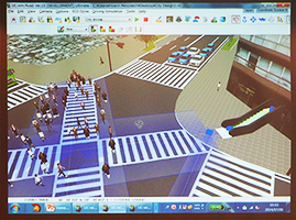
Associate Prof. Taro Narahara, New Jersey Institute of Technology (NJIT)
/ USA
"The research and education with sensors and robotics" |
| He
has been engaged in the projects to simulate the human behaviors on
architectural spaces and visualize it in 3D environment since 2000's
after his experience of 3D design at an architectural design office as
an designer. Moreover the part of his research results has been
implemented as crowd simulation function in UC-win/Road. Nowadays, the
research about the interaction to dynamically make the constraint
conditions of routes link with crowd simulation etc. has been advanced.
In addition, the study to express the simulated crowd movement on the
building models as projection mapping was also conducted with
Associated Prof. Yoshihiro Kobayashi of Arizona State University. |
■Associate Prof. Taro Narahara |
| These researches are now more advanced and the researches aith various
kinds of devices including sensors, robotics, digital fablication etc.
have been conducted. The developed system to practically operate robots
according to the simulation results is being used for education in New
Jersey Institute of Technology (NJIT). |
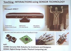
■The research example using robotics and sensors |
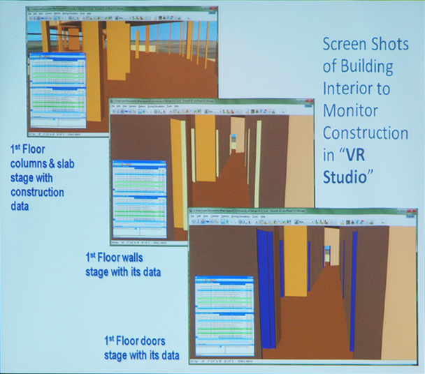
Associte Prof. Wael Abdelhameed, University of Bahrain / Bahrain
"The construction management system to link VR with MS Project and
GIS" |
■Associte Prof. Wael Abdelhameed |
| He has studied to use VR for project management and to visualize building
structures and construction process. By using the various kinds of import
functions implemented into UC-win/Road, 3D models including buildings can
be imported. In order to express the construction process from the basic
construction to the ground floor, wall and then ceiling, VR has been linked
with MS Project and GIS. XML file is used to give a change to building
through "microsim player" of VR-Studio®. |
| Because the required infomation is different between the people who control
the overall system including president and project manager and an engineer
in construction company, for example, it is important to provide the required
information which meet according to the positions in a company.Moreover
it is required to design the buildings and spaces while taking into consideration
the function, environment etc. of the city for urban design. According
to the practical training of urban design via VR for students, it was found
that it was effective. |
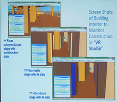
■Example of VR application for construction management |
Associate Prof. Thomas Tucker, Virginia Polytechnic Institute and State University, USA
"The development of a VR model of the bat, and an analysis of the
bat's movement via motion capture" |
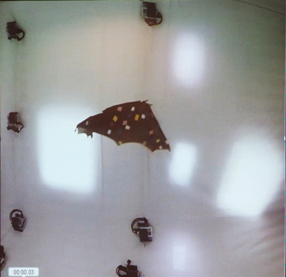
| He is involved in a research on
"Motion capture". By attaching a number of markers on a person or
object and videotaping him/her/it, his/her/its position, movement,
metamorphosis, etc. can be analyzed quantitively by tracking the
markers. Virginia Polytechnic Institute and State University and
Shandong University did a joint research on the movement of bats living
in one of the caves in China, using this technology. Several markers
were attached on the wings and membrane of a bat's body. The bat was
then released so that it can fly inside cave in which 10 video cameras
are installed to record the movement of the bat's wings. To analyze the
movement of the bat's head, a marker was drawn on its face in such a
way so as to resemble a face painting, to provide a reference for an analysis of the head's
movement. |
■Associte Prof. Thomas Tucker |
| In
addition, the skeletal structure of the bat was scanned by a small CT
scan scanner to use the scanned result as a reference for creating a 3D
model of the bat that accurately represent its real counterpart. The
internal shape of the cave was measured by a 3D laser scanner, and in
the end a complete VR model of the bat and the cave was reproduced
successfully. |

■Motion capture of a bat |
Associate Prof. Ronald Hawker, University of Alberta, Canada
"Reproduction of a philosophical experience born from new technology" |
■Associte Prof. Ronald Hawker |
| In
the world of engineering, we tend to seek new technology that can
design projects or exchange information more effectively and
efficiently. On the other hand, humans search for a philosophical
meaning of the expereience gained from the new technology. While we
constantly feel the need to cause a technological revolution so that we
can exploit a newer technology resulting from the revolution, we also
have the strong desire to discover how the new technology brings us new
stories and gives us philosophical experience. The video
shown during the presentation gives us as human being 2 major
challenges. |
The first challenge is to find answer to the
question "How is education using VR, in particular the education in
humanity and social science, important?". VR gives us a
philosophical
insight in the prediction of the future and at the same time reproduces
the experiences gained from real life.
The other challenge relates to the issue of whether we can
visualize the cultural and physical stories made over time and space
within the VR environment and at the same time take control of the
environment itself. In particular, time, living things, and the
universe will be integrated together. The experience of traveling
through our own image of time, space, and the universe that we have in
the back of our head, similar to the kind of experience you would
encounter when watching a movie, will be presented in the form of VR
based on this type experience using UC-win/Road in Tokyo. |
■A video that Mr. Ron Hawker screened. |
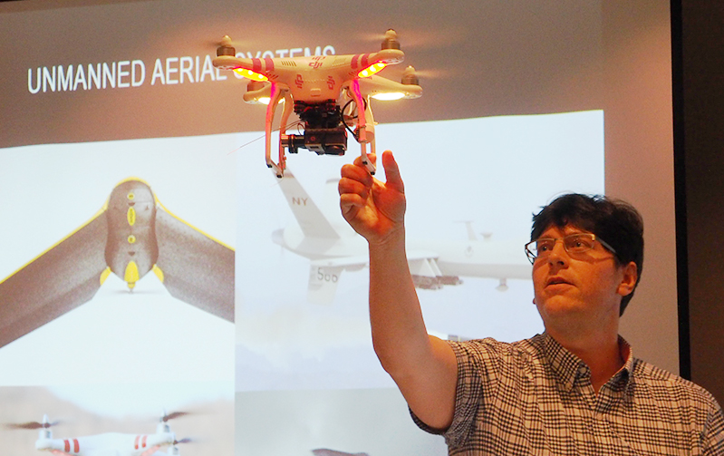
| Prof. Matthew Swarts, Georgia Institute of Technology, USA |
■Prof. Matthew Swarts |
| It is important to involve as many people as possible when it comes to
urban design. VR technology is effective in reviewing the arrangement of
buildings and rooms within each building situated in a particular area,
funds appropriate for the buildings, and spatial design of each and every
room. UAV (Unmanned Aerial System) whose practical application is progressing
recently, broadens the field-of-view of VR application a great deal, allowing
an easy and efficient use of the VR technology. For instance, UAV can take
sequence photographs and aerial videos of the development site and record
the movement of the pedestrians by setting the flight path into the UAV
by GPS (Global Positioning System). Highly precise dense point cloud data
can be generated from these images, and the addition of mesh data and textures
can also be done. |
| Furthermore, a map can be generated via aerial photogrammetry. By comparing
this map with the one created based on the previous aerial photo, the changes
made to the target site can be seen at a glance. By importing this map
data along with the colored point cloud data to UC-win/Road to use
them as a very accurate map and guide on which to build a model of roads,
trees, and green tract of land; and by importing 3D buildings created by
3ds Max as well, the target site can be reproduced very realistically within
the 3D VR environment. |

■UAV was flown in the presentation hall to show the audience a demonstration of the sytem |

An interim report on the number of applications to "The 4th Student BIM
& VR Design Contest on Cloud" (hereafter, VDWC) and "The 2nd
Student Cloud Programming World Cup" (hereafter, CPWC), and comments
on the work outline and submitted by each applicant was given by
members of the Judging Committee of each competition, as a first round
evaluation preceding the Awards Ceremony scheduled for November
20th in Shinagawa, Tokyo, Japan. Mr. Yasushi Ikeda, professor of
Graduate School of Keio University and the chief of VDWC Executive
Committee revealed the objective of this evaluation saying "There were
entries from 38 teams. We will not eliminate any teams but rather give
our feedback on the submissions, which would hopefully lead to the
completion of work by each applicant in a quality as high as possible.
Mr. Tomohiro Fukuda, an associate professor of Osaka University and the
head of CPWC Judging Committee announced the number of applicants to
CPWC by stating "There were submissions from 9 team as of July 8th". As
with VDWC, the objective of the first round evaluation for CPWC was to
keep rather than eliminate the submissions for the judgment period
scheduled in October to choose the nominees at that time.
 |
 |
| ■VDWC judges (left) and CPWC judges (right) giving their comments on the submissions. |

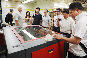
Day 2 (July 9th) included a "Technical tour"consisting of a visit
to buildings in and around the University of Hawaii campus in the morning
and a trip to Tetsuo Harano H-3 Tunnel in the afternoon. Research presentations
were given by 4 researchers to the participating members on campus as part of the
tour in the morning. Interesting topics were presented including the production
of a water-proof case, which is designed for use underwater and controlled
by 3D CAD and CNC (Computer Numerical Control) router; and the next generation
calligraphy art that represents the world famous city in the form of a physical
3D model with alphabets that portray buildings, the whole model being created
from a 3D printer. Following the presentations, the members went inside
one of the buildings on campus known as a studio full of machine tools
from 3D printer to CNC router, and from laser cutter to circular sawing
machine. They had a brief look at those tools and 3-dimensional maps made
by those tools, plus a jig used for cutting out a plywood.
 |
 |
■Research presentation in the University of Hawaii (left)
and a visit to the studio (right) |
 |
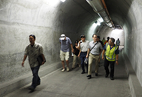 |
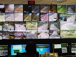
■Control Center with many monitors (left)
and a tour inside a part of the tunnel used for maintenance (right). |

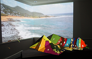
The
highlight of this workshop was a project referred to as "Production of
Projection Mapping within 48 hours" by World 16 members. The members
commenced their work on the production in the afternoon of Juy 9th,
their first task being the creation of a three-dimensional screen
representing a model of one of the Hawaiian islands, which was done in
the following procedure: Build a 3D model of the screen in 3dMax,
generate a polyhedron from the model using a software called Pepakura
Designer, print the polyhedron in a cardboard, cut out the polyhedron
from the cardboard, and paste the sides together using glue or packing
tape. The cardboard, which was procured onsite, came in various
thickness and stiffness, so the pasting work alone was quite
challenging.
The work of producing the image to be projected on the
three-dimensional screen and the background wall started on the final
day (July 11th). The work was done quickly by editing the image as to
fit it nicely on the 3D screen and wall. They did go through a bit of
trouble though, when they had to re-edit the image due to the projector
moving away from the correct position. The entire work was done in
secrecy without others who did not take part in the work but attended
the Hawaii Workshop itself knowing that the work was taking place. The
final work was presented in the evening of July 11th as the last event
of the workshop. In the projection mapping screening party following a
presentation by Mr. Satoshi Machida, chairman of The State of the Art
Technologies in Expression Association who served as an advisor in the
projection mapping project, there were cheers from the crowd for the
outstanding work. The images depicting the roads as well as the natural
and geological features of Hawaii including the lava flow were
projected as perfect fits on each and every surface of the 3D screen,
and the room was filled with an excitment and a round applause from the
audience.
 |
 |
| ■Screening party (right) that took place following a presentation by Mr.
Satoshi Machida (left). |
|
>>Schedule of The International VR Symposium (The 5th Summer Workshop in Hawaii) |