| Overview |
|
The Tsunami Plug-in is one of UC-win/Road’s plug-in options that imports and visualizes the results of tsunami analysis.
Different analysis software exports analysis result to a different format, which means analysis results from around the world come in various file formats. A standard file format has been established to realize the import of tsunami analysis result in various different file formats to UC-win/Road instead of making the Tsunami plug-in deal with all these different file formats out there. The establishment is indeed a revolution as data can now be exchanged smoothly and seamlessly between UC-win/Road and the 3rd party analysis program.
A detailed specification of the standard file format has been released allowing our valued users to convert their data in accordance to their working environment.
More developments are being planned including the ability to visualize flow velocity and wave force.
|
| Standard Format |
|
This format uses the following three types of files
▼Data File Relationships
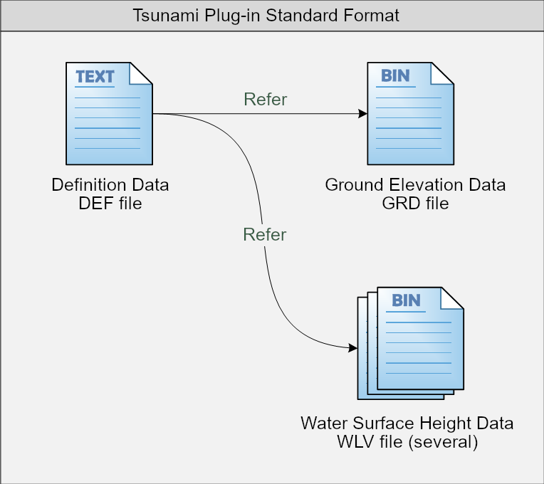
|
| Definition data DEF file |
|
【Format】
Plugin = Tsunami
FormatVersion = [Version Number]
MeshRows = [Number of Grid Rows]
MeshColumns = [Number of Grid Columns]
MeshInterval = [Grid Interval]
TimeInterval = [Elapsed Time per Step]
Position = [Grid Placement Position]
DEP_File = [Name of Ground Elevation Data File]
SUP_File = [Name of Water Surface Height Data File]
SUP_File = [Name of Water Surface Height Data File]
:
: |
【Description】
This is the file that needs to be specified when loading the tsunami data. The file defines mesh information, time interval, position, GRD file, WFV file, etc.
| Data name |
Description |
| Plugin |
Fixed to Tsunami |
| FormatVersion |
Standard Format Versions |
| MeshRows |
Number of Grid Rows |
| MeshColumns |
Number of Grid Columns |
| MeshInterval |
Grid Spacing (in meters) |
| TimeInterval |
Elapsed Time per Step (in seconds) |
| Position |
Specify the grid placement position in X-Y coordinates (world geodetic system). |
| DEP_File |
Specify the ground elevation data file name (absolute or relative path) |
| SUP_File |
Specify the water surface height data file name (Absolute or relative path) |
|
| Ground Elevation Data GRD file |
|
【Format】
FILE_HEADER
GROUND_LEVEL_VALUES |
Table. FILE_HEADER
| Data name |
Offset |
Type |
Size |
Description |
| ID |
0 |
WORD |
2 |
ID representing FILE_HEADER (0xF8F8) |
| Table Size |
2 |
Int64 |
8 |
Size of FILE_HEADER (64) |
| Type of file |
10 |
WORD |
2 |
File type
0x0001 : Ground Elevation Data GRD file |
| Reserved |
12 |
BYTE |
52 |
Reserved area |
Table. GROUND_LEVEL_VALUES
| Data name |
Offset |
type |
Size |
Description |
| ID |
0 |
WORD |
2 |
ID representing GROUND_LEVEL_VALUES (0x0010) |
| Table Size |
2 |
Int64 |
8 |
Size of GROUND_LEVEL_VALUES |
| Count |
10 |
Int64 |
8 |
Number of ground elevation data (n) |
| Value |
18 |
Single |
4 * n |
Ground Elevation Data
IEEE 32-bit signed single-precision floating-point number
Grid points not to be visualized are written 0xFFFFFFFFFF |
【Description】
This file is in binary format and lists the ground height at each grid point in.
The first 64 bytes are in the FILE_HEADER table, indicating that the file is ground elevation data.
The subsequent GROUND_LEVEL_VALUES table describes the ground height.
|
| Water Surface Height Data WLV file |
|
【Format】
FILE_HEADER
WATER_LEVEL_VALUES |
Table. FILE_HEADER
| Data Name |
Offset |
Type |
Size |
Description |
| ID |
0 |
WORD |
2 |
ID representing FILE_HEADER (0xF8F8) |
| Table Size |
2 |
Int64 |
8 |
Size of FILE_HEADER (64) |
| Type of file |
10 |
WORD |
2 |
file type
0x0002 : Water surface height data WLV file |
| Reserved |
12 |
BYTE |
52 |
Reserved area |
Table. WATER_LEVEL_VALUES
| Data Name |
Offset |
Type |
Size |
Description |
| ID |
0 |
WORD |
2 |
ID representing WATER_LEVEL_VALUES (0x0020) |
| Table Size |
2 |
Int64 |
8 |
Size of WATER_LEVEL_VALUES |
| Count |
10 |
Int64 |
8 |
Number of water surface height data (n) |
| Value |
18 |
Single |
4 * n |
Water Surface Height Data
IEEE 32-bit signed single-precision floating-point number
Unflooded grid points describe 0xFFFFFFFFFF |
【Description】
This file is in binary format and lists the water surface height at each grid point.
The first 64 bytes are in the FILE_HEADER table, indicating that the file is ground elevation data.
The subsequent GROUND_LEVEL_VALUES table describes the water surface height.
|
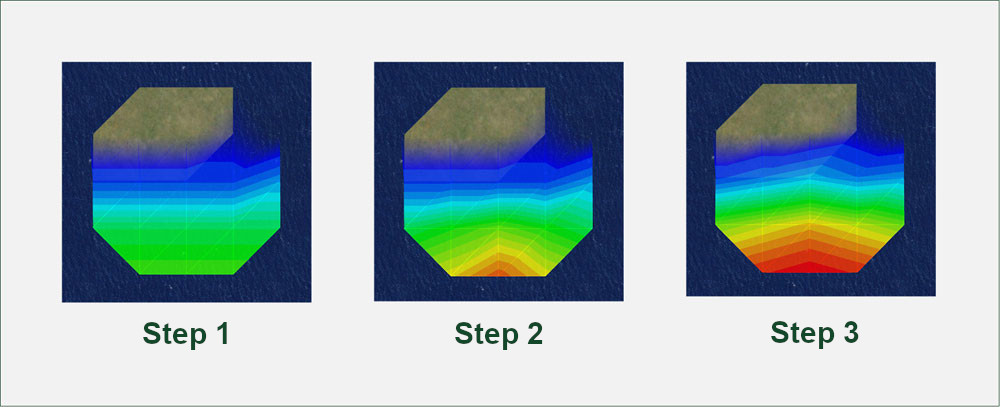
| Example: In the case of describing tsunami data for the following 5 x 5 grid and 3 steps |
|
| Grid Position |
Ground Elevation (m) |
Water Surface Height (m) |
| Row |
String |
Step 1 |
Step 2 |
Step 3 |
| 1 |
1 |
Do not visualize |
- |
- |
- |
| 1 |
2 |
36.810 |
Unflooded |
Unflooded |
Unflooded |
| 1 |
3 |
35.720 |
Unflooded |
Unflooded |
Unflooded |
| 1 |
4 |
35.720 |
Unflooded |
Unflooded |
Unflooded |
| 1 |
5 |
Do not visualize |
- |
- |
- |
| 2 |
1 |
14.880 |
Unflooded |
Unflooded |
Unflooded |
| 2 |
2 |
14.880 |
Unflooded |
Unflooded |
Unflooded |
| 2 |
3 |
14.880 |
Unflooded |
Unflooded |
Unflooded |
| 2 |
4 |
-0.510 |
0.000 |
0.000 |
0.000 |
| 2 |
5 |
0.510 |
Unflooded |
Unflooded |
Unflooded |
| 3 |
1 |
-1.410 |
0.000 |
0.000 |
0.000 |
| 3 |
2 |
-1.410 |
0.000 |
0.000 |
0.500 |
| 3 |
3 |
-1.410 |
0.000 |
0.000 |
1.000 |
| 3 |
4 |
-1.410 |
0.000 |
0.000 |
0.500 |
| 3 |
5 |
-2.180 |
0.000 |
0.000 |
0.000 |
| 4 |
1 |
-3.580 |
0.000 |
0.000 |
1.000 |
| 4 |
2 |
-3.580 |
0.000 |
0.500 |
1.500 |
| 4 |
3 |
-3.580 |
0.000 |
1.000 |
2.000 |
| 4 |
4 |
-3.580 |
0.000 |
0.500 |
1.500 |
| 4 |
5 |
-3.580 |
0.000 |
0.000 |
1.000 |
| 5 |
1 |
Do not visualize |
- |
- |
- |
| 5 |
2 |
-4.360 |
0.000 |
1.000 |
2.500 |
| 5 |
3 |
-4.360 |
0.000 |
2.000 |
3.000 |
| 5 |
4 |
-4.360 |
0.000 |
1.000 |
2.500 |
| 5 |
5 |
Do not visualize |
- |
- |
- |
Example1.def
Plugin = Tsunami
FormatVersion = 1.0
MeshRows = 5
MeshColumns = 5
MeshInterval = 50
TimeInterval = 60
Position = 4000 0 4000
DEP_File = Example1.grd
SUP_File = Example1-1.wlv
SUP_File = Example1-2.wlv
SUP_File = Example1-3.wlv |
Example1.grd
Address | 00 01 02 03 04 05 06 07 08 09 0a 0b 0c 0d 0e 0f
------------------------------------------------------------
0x00000000 | f8 f8 40 00 00 00 00 00 00 00 01 00 00 00 00 00
0x00000010 | 00 00 00 00 00 00 00 00 00 00 00 00 00 00 00 00
0x00000020 | 00 00 00 00 00 00 00 00 00 00 00 00 00 00 00 00
0x00000030 | 00 00 00 00 00 00 00 00 00 00 00 00 00 00 00 00
0x00000040 | 10 00 76 00 00 00 00 00 00 00 19 00 00 00 00 00
0x00000050 | 00 00 ff ff ff ff 71 3d 13 42 48 e1 0e 42 48 e1
0x00000060 | 0e 42 ff ff ff ff 7b 14 6e 41 7b 14 6e 41 7b 14
0x00000070 | 6e 41 5c 8f 02 bf 5c 8f 02 3f e1 7a b4 bf e1 7a
0x00000080 | b4 bf e1 7a b4 bf e1 7a b4 bf 1f 85 0b c0 b8 1e
0x00000090 | 65 c0 b8 1e 65 c0 b8 1e 65 c0 b8 1e 65 c0 b8 1e
0x000000a0 | 65 c0 ff ff ff ff 1f 85 8b c0 1f 85 8b c0 1f 85
0x000000b0 | 8b c0 ff ff ff ff |
Example1-1.wlv
Address | 00 01 02 03 04 05 06 07 08 09 0a 0b 0c 0d 0e 0f
------------------------------------------------------------
0x00000000 | f8 f8 40 00 00 00 00 00 00 00 02 00 00 00 00 00
0x00000010 | 00 00 00 00 00 00 00 00 00 00 00 00 00 00 00 00
0x00000020 | 00 00 00 00 00 00 00 00 00 00 00 00 00 00 00 00
0x00000030 | 00 00 00 00 00 00 00 00 00 00 00 00 00 00 00 00
0x00000040 | 20 00 76 00 00 00 00 00 00 00 19 00 00 00 00 00
0x00000050 | 00 00 ff ff ff ff ff ff ff ff ff ff ff ff ff ff
0x00000060 | ff ff ff ff ff ff ff ff ff ff ff ff ff ff ff ff
0x00000070 | ff ff 00 00 00 00 ff ff ff ff 00 00 00 00 00 00
0x00000080 | 00 00 00 00 00 00 00 00 00 00 00 00 00 00 00 00
0x00000090 | 00 00 00 00 00 00 00 00 00 00 00 00 00 00 00 00
0x000000a0 | 00 00 ff ff ff ff 00 00 00 00 00 00 00 00 00 00
0x000000b0 | 00 00 ff ff ff ff |
Example1-2.wlv
Address | 00 01 02 03 04 05 06 07 08 09 0a 0b 0c 0d 0e 0f
------------------------------------------------------------
0x00000000 | f8 f8 40 00 00 00 00 00 00 00 02 00 00 00 00 00
0x00000010 | 00 00 00 00 00 00 00 00 00 00 00 00 00 00 00 00
0x00000020 | 00 00 00 00 00 00 00 00 00 00 00 00 00 00 00 00
0x00000030 | 00 00 00 00 00 00 00 00 00 00 00 00 00 00 00 00
0x00000040 | 20 00 76 00 00 00 00 00 00 00 19 00 00 00 00 00
0x00000050 | 00 00 ff ff ff ff ff ff ff ff ff ff ff ff ff ff
0x00000060 | ff ff ff ff ff ff ff ff ff ff ff ff ff ff ff ff
0x00000070 | ff ff 00 00 00 00 ff ff ff ff 00 00 00 00 00 00
0x00000080 | 00 00 00 00 00 00 00 00 00 00 00 00 00 00 00 00
0x00000090 | 00 00 00 00 00 3f 00 00 80 3f 00 00 00 3f 00 00
0x000000a0 | 00 00 ff ff ff ff 00 00 80 3f 00 00 00 40 00 00
0x000000b0 | 80 3f ff ff ff ff |
Example1-3.wlv
Address | 00 01 02 03 04 05 06 07 08 09 0a 0b 0c 0d 0e 0f
------------------------------------------------------------
0x00000000 | f8 f8 40 00 00 00 00 00 00 00 02 00 00 00 00 00
0x00000010 | 00 00 00 00 00 00 00 00 00 00 00 00 00 00 00 00
0x00000020 | 00 00 00 00 00 00 00 00 00 00 00 00 00 00 00 00
0x00000030 | 00 00 00 00 00 00 00 00 00 00 00 00 00 00 00 00
0x00000040 | 20 00 76 00 00 00 00 00 00 00 19 00 00 00 00 00
0x00000050 | 00 00 ff ff ff ff ff ff ff ff ff ff ff ff ff ff
0x00000060 | ff ff ff ff ff ff ff ff ff ff ff ff ff ff ff ff
0x00000070 | ff ff 00 00 00 00 ff ff ff ff 00 00 00 00 00 00
0x00000080 | 00 3f 00 00 80 3f 00 00 00 3f 00 00 00 00 00 00
0x00000090 | 80 3f 00 00 c0 3f 00 00 00 40 00 00 c0 3f 00 00
0x000000a0 | 80 3f ff ff ff ff 00 00 20 40 00 00 40 40 00 00
0x000000b0 | 20 40 ff ff ff ff |
Visualization in UC-win/Road (contour display)
 |

