|
|||||||||||||||||||||||||||||||||||||||||||||||||||||||
|
|||||||||||||||||||||||||||||||||||||||||||||||||||||||
|
Report on the FORUM8 hands-on experience seminar attended by construction IT journalist Ryuta Ieiri. We will introduce the new products and various UC-1 technology seminars. The report will cover product overview and features, hands-on content, case studies and applications, Ieiri comments and proposals, and future prospects of the product. |
|||||||||||||||||||||||||||||||||||||||||||||||||||||||
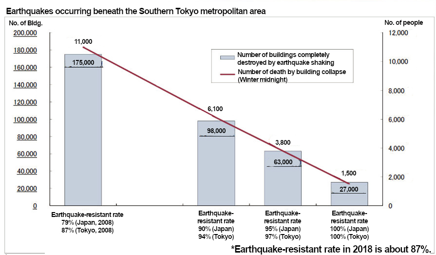
Efforts to Strengthen the National Land At Forum8's annual event "Design Festival" held in 2020, Mr. Yasushi Yamamoto, Counselor, Office for Promotion of National Land Resilience, Cabinet Secretariat, gave a lecture titled "Recent Efforts for National Land Resilience". In this seminar, he introduced the contents of the lecture and explained the efforts and effects of national land strengthening in Japan in an easy-to-understand talk. The 1959 Ise Bay typhoon, which caused the largest number of deaths and missing persons since the Meiji era (1868-1912), became the starting point for disaster prevention measures and triggered the enactment of the Basic Act on Disaster Management. The Great Hanshin-Awaji Earthquake of 1995 caused a massive fire that spread through the city and collapsed an elevated highway bridge, resulting in a great deal of human and material damage. The lessons learned from this disaster have led to the strengthening of earthquake resistance of infrastructure and the recognition of the importance of "self-help" and "mutual-help", and the concept of "disaster mitigation" was firmly established.
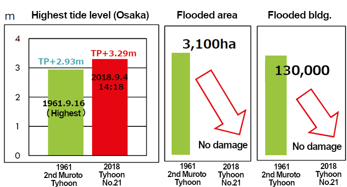
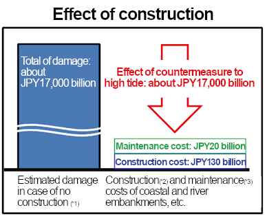
In fact, when Typhoon No. 21 hit Osaka Bay in September 2008, the tide level was 36 centimeters higher than the previous highest tide level of the second Muroto typhoon in 1961, but the area of inundation, which had previously been about 3,100 hectares, was reduced to zero. While the cost of maintenance of beaches and river levees was about 130 billion yen, and the cost of maintenance and management after 1965 was about 20 billion yen, the damage if storm surge countermeasures were not implemented is expected to be about 17 trillion yen. From these figures, we can see that the cost effectiveness of national land fortification is high.
Resilience Design Awards Forum8 has been an early provider of solutions for national infrastructure enhancement, ranging from planning and design using BIM (Building Information Modeling) and CIM (Construction Information Modeling) to strengthen social infrastructure, to analysis, simulation, and visualization of damage using VR (Virtual Reality). Our solutions range from planning and design using BIM (Building Information Modeling) and CIM (Construction Information Modeling) to strengthen social infrastructure, to analysis, simulation, and visualization of damage using VR (Virtual Reality), as well as "i-Construction" promoted by the Ministry of Land, Infrastructure, Transport and Tourism. Forum8 has been holding a contest called the National Resilience Design Award (NaRDA) since 2014 to support engineers who are working on national resilience. Forum8's BIM/CIM, VR, analysis, simulation software, and cloud computing are used to evaluate the earthquake resistance of social infrastructure, reinforce it, and simulate damage.
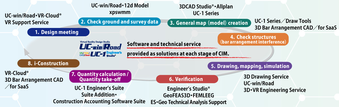
Product Overview and Features "National Land Resilience" is an initiative to prepare for natural disasters in advance and minimize the damage. As part of its "IM&VR/ National Land Resilience Solutions," Forum8 offers the real-time VR system "UC-win/Road," the design and analysis solution "UC-1 Engineer's Studio," and the BIM/CIM software "Allplan series, etc., according to the phase of the project. The phases are (1) design discussion, (2) geotechnical and survey data confirmation, (3) general drawing (model) creation, (4) structural check (reinforcement interference), (5) drawing, diagramming and simulation, (6) design verification, (7) quantity calculation, cost estimation and bidding, and (8) construction and i-Construction.
Solutions are also provided by type of construction, including (1) steel structures and concrete, roads, (2) urban and regional planning, ports and airports, railroads, (3) soil and foundations, rivers, erosion control, coasts and oceans, (4) electric power civil engineering, tunnels, construction planning, construction equipment, set metal, construction environment, and (5) IT-related and others. These "phase-specific" and "construction-type" solutions cover the warp and weft of national land resilience like a thread, and the features of these solutions are that they can exchange data in "IFC format" and "LandXML format" among themselves to realize flexible countermeasures.
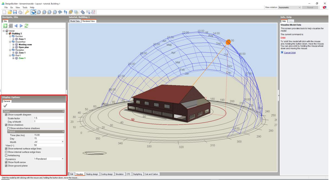
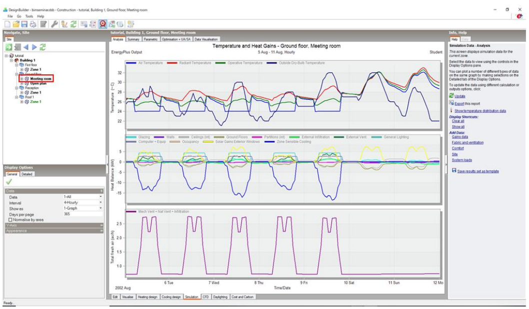
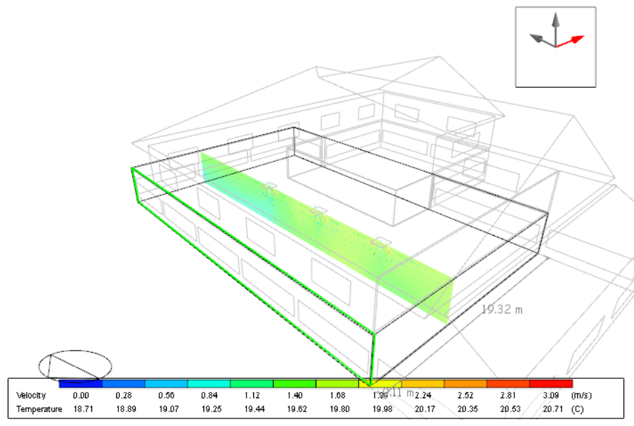
In order to prevent global warming, which is the cause of floods and other catastrophic events, it is important to improve the energy efficiency of buildings and reduce CO2 emissions, which can be called a fundamental measure to strengthening the nation. In addition to the external shape of the building and the size and location of the windows, the material and thickness of the insulation in the walls, the specifications of the floors and walls, and the solar radiation from the sun can be analyzed, and the heat generated by the windows, walls, and people in the building can be tabulated to determine the heat balance and the amount of ventilation required. In the CFD analysis, air conditioning vents were installed in the room and the air velocity and temperature distribution in each part of the room were obtained by 3D analysis. The results were exported to 3DDXF format for use in the next Allplan exercise.
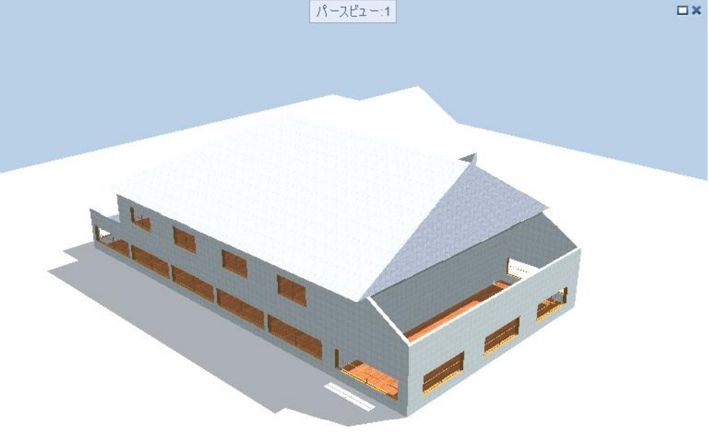
In the following Allplan practice, the 3DDXF data from earlier was loaded into Allplan and edited for texture assignment, etc. Then, using another building model, BIM modeling of facades, etc., 3D reinforcement, and quantity calculation were performed.
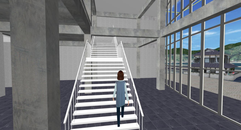
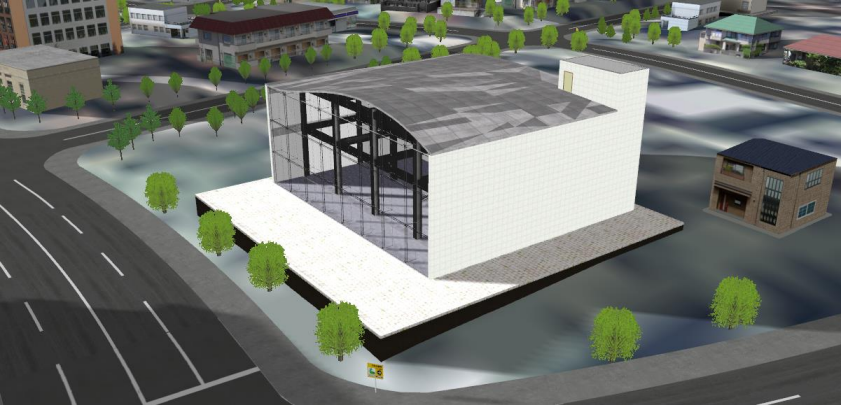
The next step was to practice using UC-win/Road. The buildings created in Allplan were placed on top of the terrain model where roads were placed, and walk-through landscape study, sun and shadow simulation, and sunshine calculation using the environmental assessment plug-in were conducted.
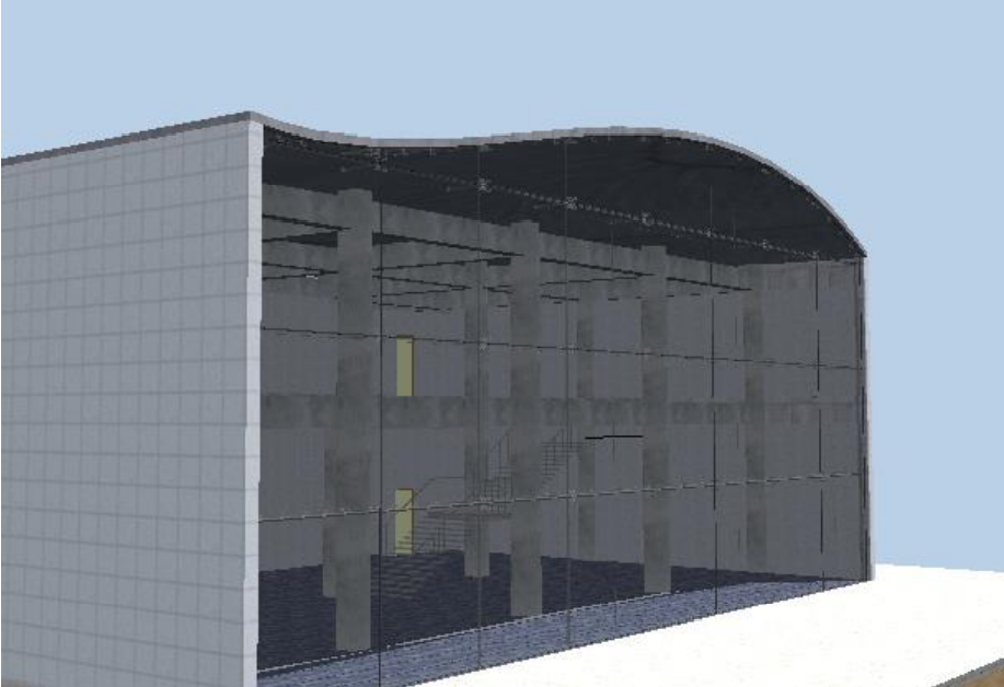
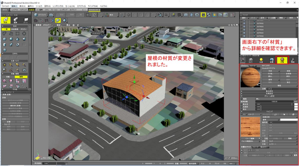
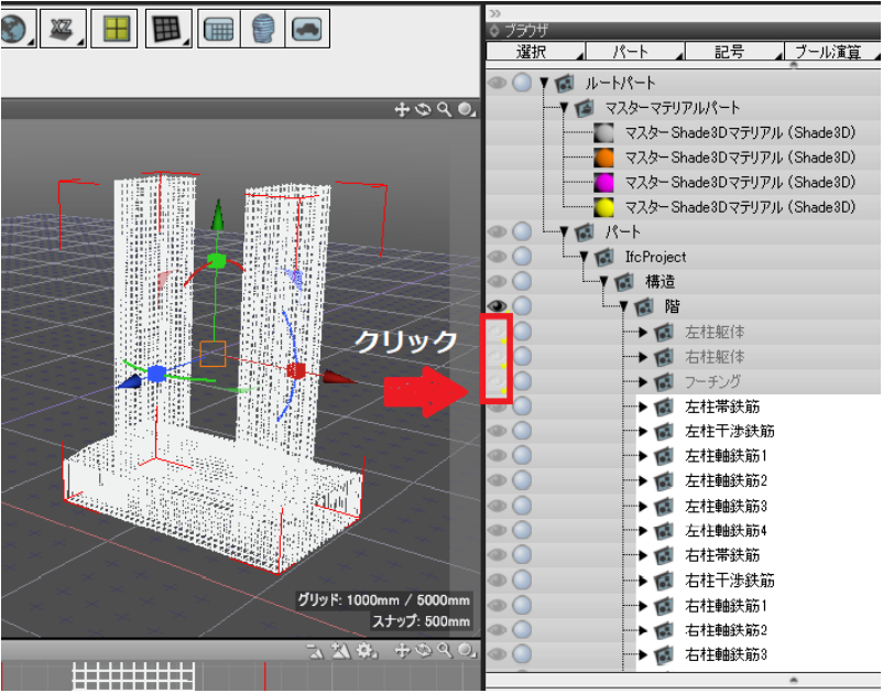
Shade3D, an integrated 3D content creation software, then read the UC-win/Road data in "3DS format" and set the roof material to more realistic data for high quality rendering. Finally, we imported the CIM model of the bridge pier in IFC format into the "BIM/CIM Design Verification Tool", checked the interference between reinforcing bars, and based on the results, avoided interference in the design stage.
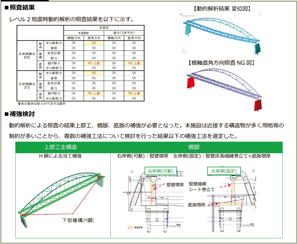
Ieiri comments and suggestions Preventive maintenance" in the areas of national land resilience and maintenance of structures is extremely cost-effective compared to the methods of restoration and reconstruction after damage has occurred. However, it is difficult for the general public to understand the necessity of such measures, since they are taken before any damage occurs in front of their eyes, and there is a risk that they will tend to be neglected. In such cases, solutions such as Forum8's UC-win/Road and F8VPS (Virtual Platform System) are very effective in helping people to imagine what the situation would be like in the event of damage. In the future, VR-related systems will be an indispensable solution for "front-loading" in the disaster prevention field. ●To be published in the next issue Dynamic Analysis Seminar (Existing and Reinforced) Tuesday, January 25, 2022 |
|||||||||||||||||||||||||||||||||||||||||||||||||||||||
|
|
|||||||||||||||||||||||||||||||||||||||||||||||||||||||


| (Up&Coming '22 New Year Issue) |
|
Up&Coming  |
