| New Products & Service | System Development Service | |
●PriceTBD ●To be releasedin March 2022 |
||
|
System Overview We build a digital twin system that can construct the same condition in the virtual space as the physical space by attaching high-precision GNSS positioning devices to heavy machines at construction sites and linking them with UC-win/Road via wireless network. Features ●High-precision positioning The RTK (Real Time Kinematic) method is used to obtain highly accurate position data by exchanging information between base stations and mobile stations for position correction. In the environment where satellite information can be received normally, the expected error will be 10 cm or less. * A situation where satellite information can be received normally means that GNSS signals from four or more satellites can be received by the base station and mobile station receivers. ●Hardware Customization Since FORUM8 manufactures the mobile station device used for RTK, we can customize it as required. By adding switches to the mobile station devices, it can not only just transmit position information but also send status to UC-win/Road with input operation. In addition, attaching buzzers and LED makes it possible to send notification from UC-win/Road to device. The mobile station device is small, which size is W96mm × D145mm × H20mm (without antenna and battery), and works by being connected to a battery for IoT devices. ●Real-time Simulation In UC-win/Road, users can build a virtual space with terrains and buildings, which are in the physical space to be simulated. In the virtual space, it is possible to simulate what is happening in the real space in real time by transmitting positional information from each mobile station to UC-win/Road and displaying and moving 3D models in the virtual space based on the information from the mobile stations. The positioning of heavy machines can be checked from various camera positions such as from cockpit, fixed camera, satellite camera, etc. ●Simultaneous Operation Since individual ID can be given to mobile station devices, multiple devices can be connected at the same time. In addition, attributes can be set to sort machine types such as backhoe and bulldozer. By switching 3D models to be displayed in UC-win/Road depending on the attributes, the locations of each machine are displayed clearly. 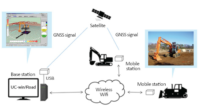
|
||
| (Up&Coming '22 New Year issue) |
|
|

