
| UC-win/Road Ver.3.3 | 3 dimensional real time VR software |
Last year in November 24, we released UC-win/Road Ver.3.2SP1 and are progressing in the development of the following version. This version will be focussed on the international support and the operation method improvement.
|
 |
|||||||||||||||||||||
In the disposition of the superelevation (cant) and the fill for an ordinary
section, we added a process which adjusts the terrain to the edge shape
of a road section. It is possible to set the data which are not necessary
for the expression of the superelevation (cant) and the fill, and make
with efficiency the creation decreasing the modifications.
|
|||||||||||
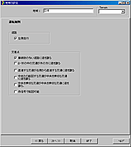
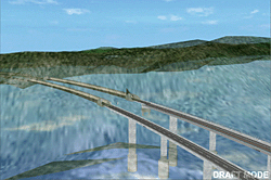
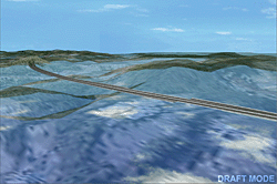
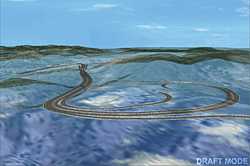
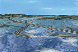
| The functions of the draft mode have been improved in order to develop
the efficiency of the road creation. - It is possible to create the road with efficiency. Because of this, creation time is lessened by hiding elements not necessary for the operation. - If you change it to the draft mode, it will be possible to alternate the transparency of the terrain, the superelevation (cant) and the fill, the river and the crossroads, the specified roads. - The results can be verified gradually by data depending on each setting. - The verification operations for the tunnel and the bridge form become easy depending on the setting of the transparency rate for the terrain. - It is possible to quicken the creation of the roads depending on the display setting of the disposition of the superelevation (cant) and the fill. It can develop the efficiency of the creation operations for the cross section. - It is possible to complete a main line road without creating a crossroad. - It will be possible to create a complicated road structure in each road like a multi-level crossroads depending on the display setting of the road.
|
|||||||||||
 |
|||||||||||
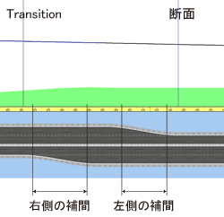
| We made the interpolation process from the place of the Transition section
to the following section setting. Now, it becomes possible to set and make
the interpolation process from the additional place of the Transition section
to the following cross section in any range of each roadway inside of the
zone. The quantity of the creation operations becomes half for the road section whose junction is not symmetrical with the center, and it will develop the operations efficiency. |
|||||||||||
| It possible to appoint the transparency rate for every part in the editing window for the section, and express the transparency of the transparent light boards, the semitransparent sound insulation wall, the barriers of protection. | |||||||||||
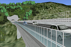
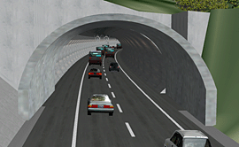
When the cars models enter into the tunnel, their texture will change to
a night texture for those models for more realistic expression.
|
||||||
The default texture is set with the sidewalk, the border, the superelevation
(cant) and the fill of the newly created road. The texture is also pasted
on the new crossroads, and it is possible to create good data seen in a
very short time.
|
||||||
| It makes smooth the display of the models depending on the performance setting of the angle of view. | ||||||
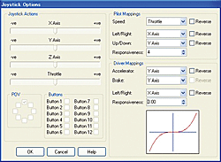
| It is possible to make the Mapping of every axis of the game controller
and to set the signal manipulation. It can support various device drivers. For example, when you set the steering controller during the drive simulation, you can set the accelerator, the reply of the brake (play) by value, and it can be changed. In addition, it is possible to set it in order to use the device during the flight simulation or the drive simulation in the visual options. |
 |
||
| It is not only for setting the altitude with the slope at each editing window for the profile, but it is possible to input directly the altitude. | |||
| We separated the graphic setting for the 3 dimensional trees and the cruciform trees. You can set independently the display or the non display. | |||
| You can create the traffic corresponding to the free time by the appointed time. The manual operations are not necessary because the traffic is created automatically at high speed with the appointed time. In addition, the speed button which permits to stop all the traffic for a while is set. | |||
