
| 3 Dimensional Realtime VR Software |
UC-win/Road for xpswmm plug-in is the plug-in tool, which imports the result of runoff and flood water analysis by xpswmm to UC-win/Road, draws floodplain flow, drainage network and flow in conduit, and displays time series simulation on 3 dimensional VR.
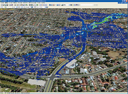
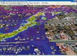
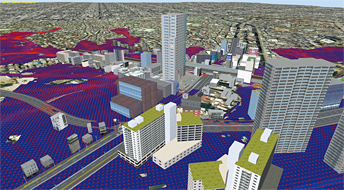
Proposal to make urban area resistant to water disaster is required in recent years. Simulation in various conditions and visually effective expression of flooded area, flood water depth and flood time and floodplain flow velocity by UC-win/Road's 3D VR allows efficient examination of the more efficient .
- Drawing flood area and depth of floodwater flow.
Draws automatically time series flood area and water depth(colored by depth) in a series of hydraulic phenomena from flood occurrence to the end , such as overflow from drainage, flood by runoff water and flood water's return to drainage pipe.
- Floodplain flow Drawing velocity of flood water
UC-win/Road for xpswmm displays time series vector of velocity of flood water.
It allows you to check visually the aspect of the flood water flow.
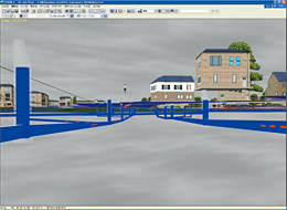
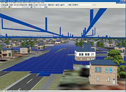
- Drawing drainage network
Possible to draw the situation of drainage network comprising wastewater pipe and manhole on 3 dimensional VR.
- Drawing flow in conduit
The plug-in can draw time series rise and fall of water level of flow in conduit and flow velocity of drainage network.
 |
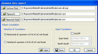
xpswmm Data Import reads surface flow, drainage network and conduit flow and adjusts coordinates between xpswmm and UC-win/Road(Cordinate adjustment between the two products). Cordinate adjustment does setting of moving horizontal coordinates in xpswmm's topographical data (coordinates in horizontal direction of analysis mesh) to coordinate position in East-West or South-North direction in UC-win/Road.
 |
|
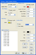
Floodplain flow Drawing Option is the drawing option to draw the surface of floodplain flow, analysis mesh, flood velocity, display flooding time, and do color setting of flood water depth. In accordance to the situation of the simulation, user can change parameters of flow velocity, color distribution by depth and etc. You can save and read set parameters here.
 |
|
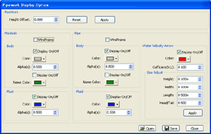
Drainage Network Drawing Option is the option to draw manhole, drainage network, flow in conduit and conduit flow velocity. It allows to choose display or hide. Since drainage network is built underground, it is not easy to see above ground, such as road, building and their usage in 3 dimensional VR.
This plug-in can offset altitude of whole drainage network. For example, user can draw the network above the ground to check and examine the validity with the land around the network.In accordance to the situation of simulation, can change parameter of flow in conduit, flow velocity and other parameters. Also allows to save and read set parameter.
 |
|
 |
 |
|||
 |
 |
|||
 |
||||
UC-win/Road for xpswmm Released at the end of September 2009
