New Products
UC-win/Road Physical Model and VR System New
Simulation / presentation system in combination with physical model and VR

Proposed system: To be released in 2011 Simulation
"UC-win/Road Physical Model and VR System" was developed based on the idea and cooperation of Associate Professor Tomohiro Fukuda of Osaka University, a member of W16. Thanks to the technology of providing a combined operation environment of physical model and VR system, it is a new type simulation/presentation tool combing the features of both environments.
The system allows you to present information effectively and efficiently to the people concerned with different background and varying knowledge levels.
Tool for examination with advantages of both physical and VR model
VR is highly flexible and expressive, and allows various considerations such as reproduction of traffic flow or changed weather conditions, which is impossible through a physical model. On the other hand, a physical model is more intuitive in grasping the big picture of the plan, such as size and project scope. Physical model allows various people to examine from the arbitrary viewpoints at the same time, understanding the whole city model simultaneously and touching the model directly.
By combining both the physical model and VR, UC-win/Road Physical Model and VR System enables considering planning with more intuitive and easier operation, compared from VR itself. In addition, by utilizing our "3D Physical Modeling Service" customers can produce physical model from VR data of UC-win/Road in a short time through the use of a 3D printer. It allows the development of a physical model and VR system effectively
Deciding the viewpoint under consideration in a physical model and displaying it in a VR model
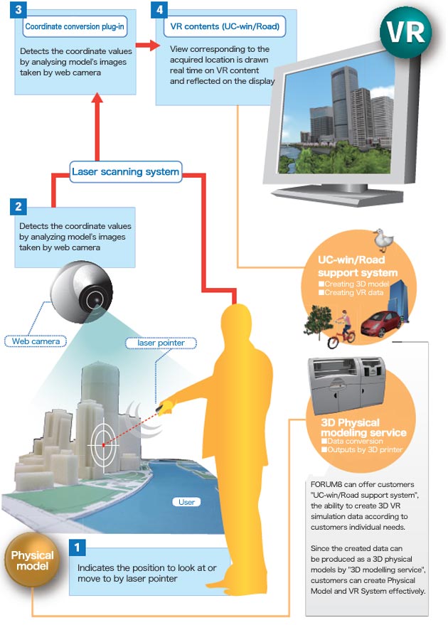
In "UC-win/Road Physical Model and VR System", you can move in the VR space and make changes in the view direction by indicating the view points to examine with laser pointer on the model.
The system consists of model, web camera, laser pointer, VR software "UC-win/Road", and display unit to view the VR display space. As a whole, the system consists of two functions: detecting laser pointer operation, passing detected information to UC-win/Road and representing it in VR space.
FORUM8 is ready to estimate and quote "UC-win/Road Physical Model and VR System" upon your request. We look forward to hearing from you.

Detecting laser pointer operation :
1
~
3
Reflecting information in VR space :
4
Processes images taken by web camera installed above the model, and detects the coordinate of the position indicated by laser pointer based on a "marker" on the model. Then, synchronizes the position on the model with the position on the VR model by converting detected coordinate values to coordinate system in VR.
(ARToolkit (*) is used as a library of infrastructure software to define the coordinate system of the model.)
By using UC-win/Road plug-in developed by UC-win/Road SDK, import obtained VR coordinates by to UC-win/Road and present corresponding landscape in the views in VR.
(Up&Coming 2011 Early Spring Issue)
BACK
Up&Coming

FORUM8