New Products
UC-win/Road Ver.9.1
3D Real-time VR Software Package

Newly PurchaseUltimate:
DrivingSim:
Advanced:
Standard:
USD17,000
USD12,000
USD9,000
USD5,800
Version UpUltimate:
Driving Sim:
Advanced:
Standard: 
USD8,500
USD6,000
USD4,500
USD2,900
UC-win Series
Simulation
  Introduction
UC-win/Road Ver.9.1 new features have been developed with enhancement of the existing features. For simulation function, driving simulation using a multi projector with Soft Edge Blending and exhibition system have been supported, that enables traffic simulation has been improved.
For modelling function, OHPASS data import plug-in has been released in UC-win/Road as the relase of OHPASS product. Point cloud modeling plug-in enables to color the point clouds with points information and composite photos.
 Soft Edge Blending
When showing the images using projectors, multi-projection, which is able to project one image with several projectors is required depending on the projected area. There is a problem that the overlapped area projected from the two adjacent projectors has too highly-intensity (see Figure 1 below).

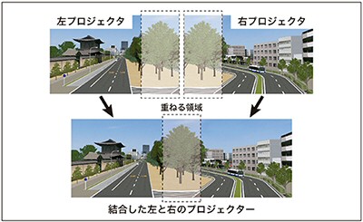
Figure 1  Problem of overlapped area with multi-projectors

To deal with this problem, although the conventional edge blending was conducted by gradually lowering the brightness to the uniform brightness distribution by using the specified graphic card (however with the limited the number of video output), UC-win/Road Ver.9.1 has been developed to be able to conduct the soft edge blending to do this processing without using the special hardware.
In particular, the digital filters are added to the output image and then the graduation processing to gradually lower the brightness of overlap area is conducted (Figure 2). This enables to display the overlap area in the uniform brightness even if the images of projector is overlap.
Moreover the projector can be supported for the various compositions including not only 2 projectors but also 6 projectors (Figure 3).


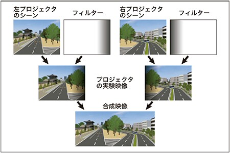
Figure 2  Digital Filtering

Figure 3  Example of 6 projectors configuration
 Scenario improvement, ACC, Auto driving function
Auto driving or drive assist function by auto recognizing the proceeding vehicle, traffic lights and limited speed has been developed so that the running vehicle with driving assist functions, which increase steadily over the years, can be simulated. The detail of the assist functions in scenario can be set and manual transfer switch at the time of driving and assist condition can also be displayed.
Assist function: Auto speed control, auto steering wheel control, brake assist function, multiple display function
Moreover the advanced simulation can be represented by changing the movement of the other vehicle and your vehicle to In Running in the scenario function. The following 2 driving condition (Driving operation and the distance between your can and proceeding car) can be mainly controlled.
  • Lane changing of the other vehicles, the average distance from the center of the lane and changing speed
  • The type of the animation of the pedestrians and changing the moving speed

Click the image for a larger picture.
Figure 4
Proceeding vehicle recognition and information display function
 Point cloud modelling plug-in and coloring point cloud function
3D point cloud data which was obtained from architecture and civil survey has been often used lately and UC-win/Road has also provided "Point Cloud Modeling Plug-in" which is a supplementary tool to visualize the point cloud data and create the road linear. However if the accuracy of the color information of the point cloud is low due to the inappropriate wheather condition at the time of measuring or because of the specification of the measuring device, the data which has originally no color information might exist.
In Ver.9.1, Point Cloud Modeling Plug-in has been expanded and the coloring point cloud function in which the color information is obtained from the separate prepared picture has been added for these point cloud.
To use this function, the folloring information is required.
  • Point cloud data to be colored
  • Several picture image
  • The coordinates of the image and camera direction
  • View angle information etc of the camera
  • The colored area and various parameters including the color correction percentage etc.

Coloring processing is conducted like following using the information above.
  1. Defining the range of the camera: Define the cone showing the direction of the camera and angle of view (Figure 5).

    Click the image for a larger picture.
    Figure 5 Camera viewing area

  2. Selecting the image of the picture used for obtaining the color information: Select the applicable image from the several images in the visual field.
  3. Correction and composition of the obtained color information: Analyze which image is correspond with which pixel per the point of point cloud and then correct the distance from the camera position to define the appropriate color information.
OHPASS plug-in option
OHPASS is a program which allows you to obtain the most excellent economic linear including the linear shape, business cost and soil volume balance etc.(first version released in Sep. 2013). OHPASS plug-in, which is used for importing the analysis result of OHPASS, allows you to analyze the unique file format of OHPASS and to combine the following information with UC-win/Road.

-Horizontal alignment and vertical alignment   -Cross section of a road
-Geography of surrounding road                   -Interval information of the earth, bridge and tunnel
-Road parameters including the number of road lane etc.

The feature of this plug-in is to allow to import the optimized road linear into UC-win/Road via OHPASS by just selecting the analysis result of OHPASS without the complex operation. Although the benefit of the front coating has been focused on due to the introduction of CIM, the various benefits including the reduction of the design period and cost saving by representing a number of road linear in various condition at the initial design stage in VR environment in a short time and multilaterally evaluating the travelling performance via driving simulation and landscape evaluation can be archieved. Below is the method to use this plug-in.

-Meeting and presentation with design contractor and the related persons
-Consensus building with the local residents and stakeholders and building PI method which is a good for environmental assessment
-Landscape evaluation and road structure evaluation and these feedback to the optimum design
-Evaluation of travelling performance and visibility via driving simulation

Click the image for a larger picture.Click the image for a larger picture.
Figure 6
Selection screen
for OHPASS analysis results
Figure 7
Evaluation of travelling performance
via driving simulation
(Up&Coming '13 Fall Issue)
戻る
Up&Coming

FORUM8