
| VR city model automatic generation tool which runs on 3DS Max POV-Ray data import tool |
- FORUM8 and Associate Professor Yoshihiro Kobayashi of Arizona State University
School of Architecture and Landscape Architecture have jointly developed
a freeware to link UC-win/Road with 3ds Max, comprising of 2 features:
- City Design : A tool that runs on 3DS Max which generates VR city models automatically
- Povray To Max : A tool which imports POV-Ray data to 3ds Max
- City Design is a tool for generating VR city models automatically. It was
developed as a plug-in option for Autodesk 3ds Max. The model generated
by City Design is saved as 3DS file which is a general format of 3D game
and can be utilized in UC-win/Road. City Design creates city models by
generating building models from the image data created using the script
function of the Autodesk 3ds Max.
Main features of the City Design include the ability to create images and drawing files of the roads and the site, using popular image editing software programs. Using programs such as Adobe Illustrator and Adobe Photoshop which are commonly used by designers with City Design shortens the time required to master VR city modeling techniques, which is one of the most time-consuming parts of the process. In short, this tool enables you to generate buildings and the environment automatically from image data and drawing data which can be created by anyone.
- Road network creation :
Road polygon data is generated by reading the Illustrator file (.ai) you have created.


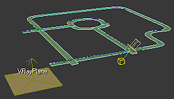
▲Figure 1 Road network creation from Illustrator file
- Site creation :
Site is generated by reading the Illustrator file (.ai) you have created.
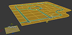
 Figure 2 Site creation
- Zone creation :
Each zone is created as an independent object by importing the image file (.tga) you have created. The red region on the left hand side in the image on the left in Figure 3 (below) is defined as a Commercial zone.

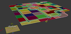 Figure 3 Zone creation
- Acquiring height data :
Foundations of the zones are created by importing the image file (.tga) you have created and the height data is assigned to each zone using DEM.
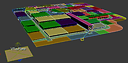 Figure 4 Acquiring height data
- Building creation within zones :
Buildings are automatically generated as shown below.
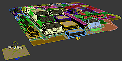 Figure 5 Building creation
- Texture Rendering :
Rendered textures and building models are extracted.
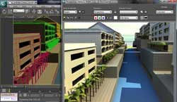 Figure 6 Texture Rendering
- Import into UC-win/Road :
Import model list metafiles, building model files (.3ds) and texture files (.jpg) by using the UC-win/Road plug-in option. Metafiles include building location data, and thus the buildings are positioned automatically.
 Figure 7 Import data by UC-win/Road
- Road network creation :
- POV-Ray is a ray tracing software available on a variety of computer platforms.
UC-win/Road has a plug-in option to export POV-Ray files. POV-ray To Max is a tool that enables export of information from UC-win/Road to 3ds Max by utilizing this function.
- UC-win/Road data :
Exports POV-Ray data by using UC-win/Road POV-Ray plug-in option.
 Figure 8 UC-win/Road data
- Export data to 3ds Max :
3ds Max POV-ray to Max plug-in allows you to import road (alignment and section) and intersection data into 3ds MAX.
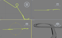 Figure 9 Import the data to 3ds Max
- Rendering with 3ds Max :
Texture data can also be imported, and then verified by rendering the data.
- UC-win/Road data :
- FORUM 8 will begin a 3ds Max data conversion service using this plug-in
option as one of the additional services of UC-win/Road support system. The service will include the following:
- Export road and intersection data with texture to 3ds Max.
- Adjust terrain data imported as LandXML
- Place the already-created models (buildings, traffic signals and trees etc.) which can be read by 3ds Max
- If there are no models available, we can model all the elements that need to be created, including the trees that are generated by UC-win/Road, to visualize the virtual environment.
- The Software Tool is available from the Vector software library (Japanese
only)
http://www.vector.co.jp/soft/winnt/art/se482202.html
* This software is a free software. Sales of the software program is prohibited.
If any modification has been made to the software by a third party, we assume the right toinformation and disclosure.
(Up&Coming 2010 Fresh green leaves issue)