| Support Topics UC-win/Road |  |
|
| Data file input and output |
| Support Topics | ||||
|
||||
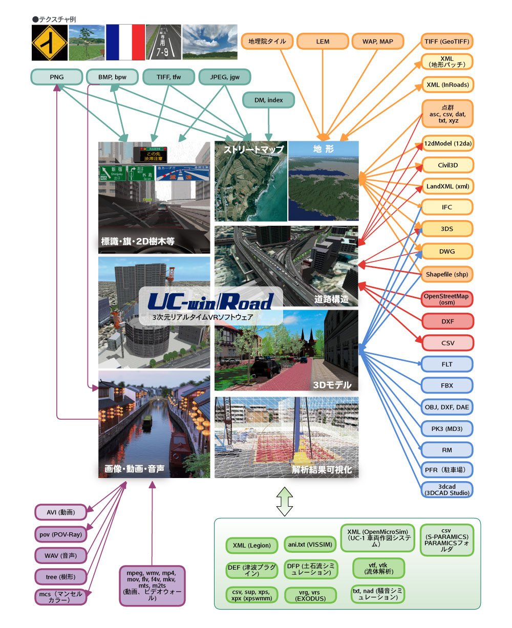
| One of the characteristics of the UC-win/Road is the data linkage with
a variety of external software. In this topic, we have listed all formats
being able to be imported to or exported from the UC-win/Road. Though formats
differ according to 3D model, terrain, road alignment, or analysis, input
and output are also supported in the general purpose format used in a lot
of software. Data file input and output in UC-win/Road
|
| 1. Terrain |
|
■Input (new generation): LandXML, Shapefile, IFC, 12dModel, TIFF, WAP, MAP, GSI Tiles (download), Civil3D (direct collaboration) ■Input (merge to current terrain): LandXML, Shapefile, IFC, 12dModel, LEM, point cloud file (terrain patch conversion), Civil3D (direct collaboration) □Output: IFC, LandXML, 12dModel, DWG, 3DS, XML (only terrain patch), Civil3D (direct collaboration) |
| 2. Streetmap |
|
■Input : JPEG, BMP, PNG, TIFF, World file (jgw/jpgw, bpw/bmpw, tfw), DM □Output : BMP (3DS file output) |
| 3. Road Constructure |
|
■Input (plan/diagonal alignment) : LandXML, Shapefile, 12dModel, OpenStreetMap, CSV (polyline conversion), Civil3D (direct collaboration) ■Input (cross section) : LandXML, DWG, DXF, Civil3D (direct collaboration) □Output (plan/diagonal alignment, cross section) : LandXML, Civil3D (direct collaboration) □Output (3D shape) : 3DS, DWG |
| 4. 3D model, material |
|
■Input (arranged model) : 3DS, RM, FBX, OBJ, DXF, DAE, FLT, 3dcad, IFC ■Input (traffic model) : 3DS, RM ■Input (character) : MD3, FBX ■Input (building model) : Shapefile ■Input (parking lot model) : PFR □Output : 3DS, RM, DWG, FLT |
| 5. Image, video, sound |
|
■Input (texture) : JPEG, BMP, PNG, TIFF ■Input (video) : AVI, MPEG, WMV, MP4, MOV, FLV, F4V, MKV, MTS, M2TS ■Input (sound) : WAV □Output : JPEG, BMP, PNG, AVI |
| 6. Simulation, analysis result |
|
■Input : OpenMicroSim (UC-1 vehicle trajectory drawing system, VISSIM,
S-PARAMICS, Legion), xpswmm (DAT), □Output : OpenMicroSim, debris avalanche simulation (DFP), noise simulation (TXT) |
| 7. Others |
|
■Input (used for location adjustment and landscape display) : point cloud file (DAT, CSV, XYZ, TXT, ASC, F8DAT) □Output : Munsell colour data (MCS) |
| Conclusion |
|
These various data linkage functions expand the usage range of the UC-win/Road. Please review and try new utilizations of the UC-win/Road. |
|
|||
| (Up&Coming '17 Fall issue) | |||
 |