| Support Topics | ||
| Support Topics UC-win/Road | ||
|
||

|
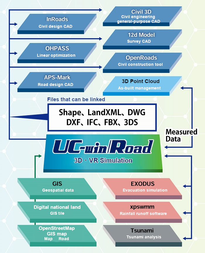
UC-win/Road, as a 3DVR platform, can read and utilize a variety of data. Structural models, traffic simulations, and various analysis data can be visualized and effectively used according to purposes. In addition, the latest Ver. 15 allows users to use open data for generating topography, road alignment, buildings, etc., and it simplifies the work and reduces the work time. In this article, we will mainly introduce the creation of VR space using GIS-related data among those data. Configuration of VR Digital Platform There is a wide range of GIS data that can be imported into UC-win/Road, such as the GSI tiles and Fundamental Geospatial Data published by the Geospatial Information Authority of Japan (GSI), building and road information from OpenStreetMap, and other point cloud data. Available file formats are such as Shapefile, LandXML, DWG, DXF, IFC, FBX, etc., and by constructing a VR space using these GIS data and outputting the data from the VR space to related software, it can be used as a platform to connect various software and systems.
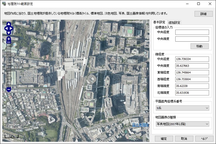
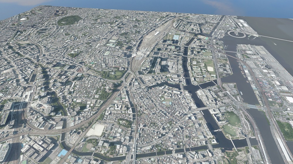
Terrain Generation Using GSI Tiles When generating a new terrain in UC-win/Road, it is possible to use the GSI tiles published by the GSI. Users can import the GSI tiles of any area on map together with a set of aerial photographs and map images to construct a VR space. Since the terrain generated from the GSI tiles has the information of plane rectangular coordinates and longitude and latitude, materials can be placed and generated at the correct location even when other GIS data is loaded on the terrain.
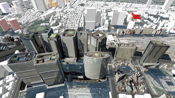
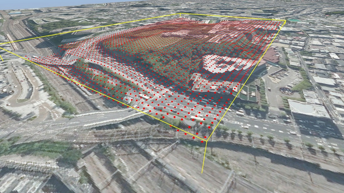
In addition to the GSI tiles, a lot of topographical information such as SRTM is available as open data. By reading elevation data file formats represented by GeoTIFF, it is possible to generate the topography of any location in the world, including Japan. Import 3D City Models ■Import PLATEAU open data models By using 3D models such as "3DBD Viewer*1" published by The National Institute of Advanced Industrial Science and Technology and "PLATEAU*2" published by the Ministry of Land, Infrastructure, Transport and Tourism (MLIT), it is possible to reproduce urban landscapes as a single model. Buildings, terrain, plantings, and roadside facilities are compiled as 3D models by area, which can be loaded into UC-win/Road via general-purpose 3D model formats such as FBX. In PLATEAU, more and more building models of major cities in Japan are being available, and they are published with not only building shapes but also various attribute information such as the number of floors and the use of buildings. UC-win/Road will soon be able to import the building models including attribute information from PLATEAU.
■Import Zenrin 3D Map Data In addition to open data, 3D city models provided by paid services can also be used in the same way. The "Zenrin 3D Map Data Online Service" by ZENRIN CO., LTD. provides 3D models that include not only buildings but also all the elements that make up the urban landscape, such as roads, road signs, power poles, and roadside trees. By specifying a variety of formats such as FBX, 3DS, etc., it is possible to download a vast range of model data and load it into UC-win/Road.
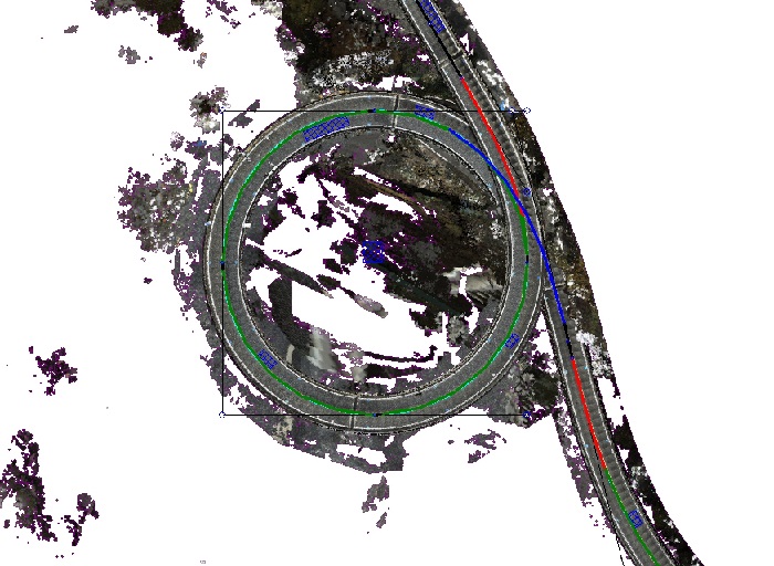
For the city models in PLATEAU and Zenrin 3D map data, the 3D models themselves have the coordinate values of the world geodetic system based on the plane rectangular coordinates, so after placing the model in UC-win/Road, setting the input value of X-Y coordinates (global coordinates) to 0,0 will place the model in the correct position in space. However, open data does not always have accurate coordinate information. In this case, you can check the origin position of the 3D model on the FBX model editing screen, and then adjust the position by comparing with the coordinates and longitude and latitude of the origin position using the GSI's map information. If you do not require much accuracy, you can also adjust the position according to the aerial photograph. Create Roads Using OpenStreetMap OpenStreetMap allows you to download the geographic information on the map as open data and automatically generate road alignments by reading the downloaded osm file. If the topography of the data you are creating is generated based on accurate coordinate information such as the GSI 50m mesh topography or GSI tiles, it will be generated at the correct position without adjusting the coordinates. Road alignments can be converted to LandXML format as well as being generated directly, so that linear information can be read by setting offsets even for terrain that does not have precise coordinates. Create Building Using OpenStreetMap and Shape Files Building information from OpenStreetMap can be read in UC-win/Road by using the "Download Features" function in the "Zone Editing" to generate a wide range of building shapes automatically. The area of creation can be specified freely in the UC-win/Road space. No troublesome operations are required since the building height information is also reflected. In addition, the names of major buildings are automatically entered. Unlike 3D city models such as PLATEAU, the buildings themselves are generated in a single color, but you can select individual buildings and apply textures to them. Compared to placing buildings from RoadDB, the impact on performance is minimal even when generating buildings in a wide range thanks to their simple shape.
Even in areas where no building information is provided in OpenStreetMap, buildings can be generated and imported in UC-win/Road using the Fundamental Geospatial Data, by converting the building external shape information via the Fundamental Geospatial Data viewer into the Shape file format. When generating buildings from Shape file, uniform texture can be applied to the sides and top in the setting. Merge Terrains Using Shape and IFC Files As well as generating buildings, you can export the topographic information from the Fundamental Geospatial Data to a Shape file and combine it with the terrain you have already created. For example, if you want to improve the accuracy of part of a 50m mesh topography, you can convert the required area to a 10m or 5m mesh topography provided by the Fundamental Geospatial Data. IFC files can also be used in the same way, and the topography used in the design can be reflected.
Import Point Cloud Data
licenseCC BY 4.0 from Shizuoka Point Cloud Database termshttps://pointcloud.pref.shizuoka.jp/terms *1 3DDB Viewer https://www.airc.aist.go.jp/gsrt/3ddb-viewer.html *2 PLATEAU https://www.mlit.go.jp/plateau/ *3 MLIT Data Platform https://www.mlit-data.jp/platform/ *4 Shizuoka Point Cloud Database https://pointcloud.pref.shizuoka.jp/ |
||||||||||||||||||