
| 3D Real Time VR Software |
- It is now possible to display videos in the UC-win/Road VR space as a 3D
object, enabling you to visualize electronic billboards etc. In UC-win/Road
Ver.5, video files saved on the local hard drive can be selected to be
displayed in the VR environment as a video wall - we are planning our development
to enable video streaming of external video files.
 How to edit videos
Each pixel of the video is represented as one polygon, which is essentially a square, and the color of the vertex is mapped to the center of the pixel on the video with gaps between colors created inside polygons using OpenGL. Pixel information of the movie file is acquired from the interface of DirectShow, which enables the use of many different file formats. In addition, the impact on the PC's performance is minimized, because the animation file is reproduced in a different thread.
Because the pixels of the video are arranged as rows of polygons, the resolution can be adjusted using a simple algorithm. The resolution of small videos on the screen can be reduced automatically, making it possible to display many video walls. Since the curvature radius of the video wall can be adjusted, cylindrical screens can also be reproduced (Figure 1).
-
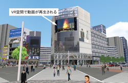
 Fig. 1: Visualization of a video wall (Shibuya scramble intersection)
- UC-win/Road Ver.5 supports FBX, Collada, Alias OBJ and DXF file formats to expand its supported 3D file formats. It was made possible using the SDK for FBX, a freeware from Autodesk.
The following information can be included in an FBX file:- Node configuration
- 3D mesh data: Patch and NURBS are divided into triangles and read as 3D meshes.
- Material: All channels (Table 1: Ambient, Diffuse, Specular, and Emissive), texture and mapping information (Ambient, Diffuse, Emissive), and transparency
Channel name Details Ambient Reflection of the ambient light: used to easily visualize the average indirect lighting from sky and close objects. Diffuse Scattered reflection: used to visualize non-glossy surfaces. Specular Mirror reflection: used to visualize glossy surfaces. Emissive Used for light sources, not a reflection Table 1 Details of channels
Various effects on a surface of models can be achieved by adjusting the levels of Ambient, Diffuse and Specular channels (Fig. 2). In UC-win/Road, the Emissive channel is used for night time simulation.
Ambient + Diffuse + Specular

Ambient + Diffuse

Ambient
 Fig. 2: Different ways objects can be visualized using channels
Following attributes can be adjusted for materials on a set screen (Figure 3).- Textures, scale, offset, and rotation
- Color and transparency of materials
-
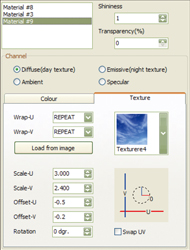 Figure 3 Defining Material Attributes
- UC-win/Road was revised to increase the display and the calculation speed; to use PCs with multi-core CPU or multi-CPU effectively, the parallel processing is now available with many of UC-win/Road's functions.
Previously, the weather, movements of clothes, flags, 3D trees and other environmental features were calculated as part of the picture processing. These calculations had been carried out in series, but in the new version, these calculations are done simultaneously, independent of the picture processing. Traffic flow calculations are also done independently of picture processing in the new version.
Additionally, drawing functions are optimized for a speedy drawing of roads, lakes and ponds, and the reflection, geographical features and the tree has been improved. Details of the improved performance are shown below, however, the performance improvement varies according to the UC-win/Road data (Table 2).
Items Improved Degree of improvement in hardware speed Parallel processing approx. 20% Visual - Roads 1-5% Lakes and marshes and other reflections 60-75% Terrain 15-20% Trees 15-20% In General 30%-110% Table 2: Details of performance improvement
- UC-win/Road now includes 3 types of sample data, ready for use after the
installation of the program. They are introduced here.
1. VR model for driving simulation (highway driving)
2. Small town model for low-spec PCs (Nihon-daira Parkway)
3. City planning VR model for high-spec PCs (Kyoto urban area)
1. Highway driving(VR model for driving simulation)
You can experience driving simulation using a game controller or a professional Driving Simulator. With the high performance display capabilities for driving simulation, high FPS (frame rate) can be achieved. The driving can be simulated along Tokyo Metropolitan Expressway from Shibuya Ward Hatagaya to Roppongi, totaling about 29km of road. 2 scenarios (one through a tunnel and another though toll gates) are included and you can experience various events by using the scenario plug-in option.
- Scenario 1 - Tunnel:
When the scenario starts, the headlight of the car is switched on as the vehicle enters the tunnel. Inside the tunnel, there will be merging traffic, and the headlights will be switched off as the vehicle leaves the tunnel.
- Scenario 2 - Tollgate:
The vehicle travels up a ramp from another road and passes through ETC (Electronic Toll Collection) gate, and then on to the expressway. Speed limit is in force at the ETC gates. Weather changes and traffic congestion can also be experienced in this scenario.
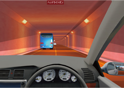
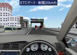 Highway driving Scenario 1 - TunnelHighway driving Scenario 2 - Tollgate
 - Scenario 1 - Tunnel:
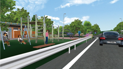
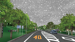
- 2. Nihon-daira Parkway (small town model for low-spec PCs)
This is a light data designed to run on low-spec PCs. Loading time is short and the operation is minimal, making it suitable to be run on laptop PCs. The data reproduces Nihon-daira Parkway in Shizuoka Prefecture with 8km of road. Not only the traffic, but pedestrians, children playing in the playground, realistic street lights, rain and snow using context function, banks on the shoulders of the road, and bon fire using fire and smoke function are visualized. All these simulations can be viewed using the script function.
In addition, it is possible to drive along the parkway using the pre-made scenario. Change of weather (rain, clouds and snow) using the context function and realistic night-time driving (with realistic lightings) can be experienced.
Since the size of this data is limited, the loading time is comparatively short and all the basic functions of UC-win/Road can be performed on PCs without high specification.
 Nihon-daira Parkway "Park"Nihon-daira Parkway "Context/snow"
- 3. Kyoto urban area and Shibuya intersection (city planning VR model for high- spec PCs)
This Kyoto Urban Area data was created as a part of "Digital City" concept. This is a large-scale urban simulation and comparatively high-spec PCs are required. Through this "Digital city" concept, we aim to employ various databases and other GIS-managed information on cities to recreate 3D cities for use in management and simulation as "City Simulators".
This data covers the 5km by 3km area of Kyoto, including Kawara-machi Street, Karasuma Street, Oike Street, Shijo Street and so on with intersections, Kamogawa River and the streetscape. Kyoto Station, Kiyomizudera Temple, and Higashi-honganji Temple and other landmarks can also be seen and the Kyoto Tower adjacent to Kyoto Station and the roadside trees along the sidewalks are visualized in detail. Two scripts have been prepared for the presentation of this urban scenery. One shows the traffic on roads and the landmarks between Kyoto Station and the Kyoto University; the other highlights the streets at night, using fake light and lighting functions - the Daimonji bon fire is also visualized using the fire and smoke functions. In the scenario, you can drive out from the multi-storey car park on Shijo Street using the ramps to reach the street level and continue on to the entrance of Kiyomizudera Temple.
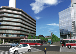 Kyoto urban area
UC-win/Road can be used in so many ways, including for traffic simulation, daytime and night-time simulation of scenery, as well as for sightseeing map and encouraging tourism. Moreover, these simulations can also be used for disaster management, large-scale evacuation and crime preventio planning.
In the latest Ver.5, the sample data that utilizes the "Video wall" function is also available. Using this function, videos can be placed on models and played inside the VR environment, even on a curved surface. In this sample data, a part of the scramble intersection in Shibuya was modeled with a large screen showing videos placed on a high-rise building.
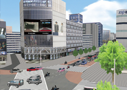 Video wall function (Shibuya intersection)
UC-win/Road Ver.5.0 planned release date August 2010