Noticing Effectiveness through Research of Streetscape Evaluation Approach,
Introducing 3D Real-time VR (Virtual Reality) in Classes
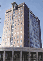
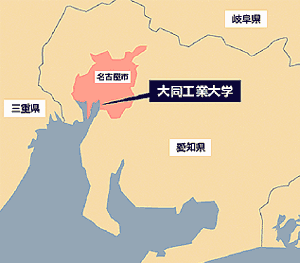
Located in the Southern part of Nagoya city, known as one of the largest areas of manufacturing industry in Japan, Daido Institute of Technology offers education with specific emphasis on training engineers able to work living up to the expectation of the economic community of central Japan. Among others, Department of Civil Engineering & Environment Design, established in 2001 to reflect the needs of new age along with reorganization of the School of Engineering, is remarkable for its unique efforts.
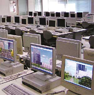
Last summer, Department of Civil Engineering & Environmental Design (DCEED) purchased Forum 8 "UC-win/Road" for the first time as a tool for research. Subsequent to the purchase, DCEED introduced from the new academic year (April 2006) 40 licenses of "UC-win/Road" to use in some of its classes. We interviewed Dr. Etsuo Funawatashi, Professor of DCEED, Dr. Masato Horiuchi, Professor of DCEED, and Dr. Yoshiaki Shimada, Associate Professor of DCEED, who strongly believes in the effectiveness of 3D real-time VR (virtual reality) software. He sought to integrate curriculum academia with 3D virtual reality, in a bid to utilize such development in researches and future classes.
the Viewpoint of Vocationalism |
The history of Daido Institute of Technology (DIT) dates back to 1939, when Daido Kogyo Educational Foundation was founded with investment by 27 companies of Central Japan including Daido Steel Co., Ltd., Chubu Electric Power Co., Inc, and Nagoya Railroad Co., Ltd. Renamed as Daido Educational Institutions, the Foundation established senior and junior high schools and junior college. In 1964, Daido Institute of Technology was founded with two departments of mechanical engineering and electrical engineering. Then the departments of construction engineering and applied electronics were added in 1975 and 1985, respectively. In 2001, the school of engineering was reorganized, when "Dept. of Civil engineering & Environmental Design" was established to take over the department of construction engineering.
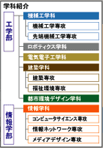
At present, DIT is composed of School of Engineering (Departments of Mechanical Engineering, Computer Mechanical System Engineering, Electrical Engineering and Electronics, Architecture, and Civil Engineering and Environmental Design) and School of Informatics, which was established in 2002. The total number of the undergraduate and graduate students is about 3,500, and the number of faculty and staff is about 230.
DCEED has 2 courses: "Infrastructure Design" Course (structural field, geotechnical & material field) and "Urban Environmental System" Course (water & environmental field, urban & transportational field). In addition, it has "Design Management" Course, common to the preceding two courses. Among these, Professor Masato Horiuchi is in charge of education and research of water & environmental field including environmental sanitary engineering. Professor Etsuo Funawatashi and Associate Professor Yoshiaki Shimada are in charge of urban & transportational field.
"We have rearranged the curricula to secure such learning environment such that the students of all majors have the abilities and skills to use every CAD software, GIS (geographic information system) to VR which have just been adopted," says Dr. Funawatashi. "Design Management Course is what makes it possible."
Having a firm educational-industrial relationship since its foundation, DIT has a consistent educational policy of vocationalism. It has also pronounced its move to becoming a college that focuses on education from the viewpoint of students, providing "2001 Class Charter of Daido Institute of Technology" (2000) to promote this. To realize it, DIT conducted workshop class to improve instructors' teaching methods with each other, and Faculty Development activity such as class assessment questionnaire by students. Having the results of these activities well evaluated, DIT was selected as "support program for good practice to address educational needs in a modernized way (Gendai GP)" by Ministry of Education, Culture, Sports, Science and Technology.
"In this sense, I believe introduction of VR is a part of efforts to develop teaching methods that are easier for students to understand," says Dr. Horiuchi. He explains that VR is introduced for the purpose of using it for technical researches and education, reflecting social needs as well.
landscape assessment items |
"I proposed that DCEED should promote such a thing like "UC-win/Road", and it was decided to be introduced last year," says Dr. Shimada.
In 2003, Ministry of Land, Infrastructure and Transport issued "Policy Guidelines for Developing a Beautiful Country" that provides land planning with emphasis on landscape. Then Landscape Law was enacted and enforced in June 2005.
Prior to the utilization of UC win/Road, Dr. Shimada had been coping with the establishment of road landscape evaluation approach. One of the challenges was how to extract elements that are largely dependent on one's senses.
In developing landscape evaluation approach, Dr. Shimada had views upon the similarity between the mechanism for human beings to evaluate landscape and "preference" that consumers perform in purchasing activities by adding various factors. He considered applying a marketing approach of "conjoint analysis." He took it into account that in street evaluations, not only landscape but also functions of traffic and space inherent to roads need to be retained as a premise. In addition, in order not to diffuse alternatives unnecessarily, he organized combination patterns of the factors to judge landscape by limiting to some extent the preconditions of landscaping (e.g. underground installation of electric cables and installation of street lights) or road width.
Different planning levels were set against 3 elements -- "What about the pavement of sidewalk?" "What about pedestrian-vehicular segregation facilities?" and "What to do with roadside trees." An approach of making a questionnaire about the combination was formed.
"In conducting this questionnaire, we hit upon using VR for the evaluation of actual landscaping through the combination of various patterns."
Examining the milestones, we realize that initially, 2 dimensional CG was used. However, the problem was that recreation of landscape by processing of digital photos can only be done using still picture images. As a result, it was a challenge to imagine the different perspectives and viewpoints among pedestrians and drivers, as well as the evaluation of sequential scenes. Subsequently, 3D CAD was introduced. Since 2003, for the purpose of reproducing landscape by dynamic picture image, 3D CAD was utilized. Using CG animation under the same conditions with 2D CG, dynamic landscape evaluation was performed. Examination of its effectiveness as well as the difference with the evaluation by 2D CG was also carried out. The downside was that 3D CG was inefficient, time-consuming, and lacking in realism.
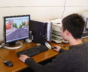
Advancements in researches led to the adoption of virtual reality (UC-win/Road) last year, so as to create expressions with increased realism.
Based on the similar conditions as before, 3 dimensional spaces were recreated with " UC-win/Road." At that time, as compared to 3D CAD, the time involved in VR data creation was cut by one third, resulting in increased efficiency. More time could then be channeled to the examination of primary work. Using these data, questionnaires were distributed to the students of DCEED. After that, it was compared with the results of streetscape evaluation by using 2D CG and 3D CG to examine the effectiveness of using VR.
Utility value for each combination was gained through a series of process, and it was found that "if tall roadside trees are maintained, basically the evaluation (utility value) increases." In addition, the benefits of VR were clear. Concrete and effective approaches were structured for landscape assessment (evaluation) and it was found that the ability to take into account factors like viewpoint differences between pedestrians and drivers, safety, or landscape was indeed amazing.
With the research outcome of the above streetscape evaluation approach and others as background, DCEED decided to introduce "UC-win/Road" in classes and so on from 2006 academic year.
It had been essential to create design drawings by hand in classes, from the idea of stressing basics. After going out into the world, it is common to design chiefly with CAD. However, looking ahead of the future when VR is widespread, it was recognized that it is necessary for early acquisition of VR skills.
As a result, diversified cases of using VR are assumed: learning how to use VR as a tool in "surveying II" in which GIS or GPS (Global Positioning System) are learned, or "road design" and "road design practice"; applying it to presentation in other courses.
Dr. Etsuo Funawatashi expects improvement in educational effect especially in his class "engineering of town building (machizukuri kogaku)." On the other hand, Dr. Masato Horiuchi points out the possibility of utilizing VR in the examining process of regenerating the River Hori flowing through the central part of Nagoya city, in which citizens have great interests now. Moreover, Dr. Yoshiaki Shimada, who noticed the usefulness of VR earlier than others and proposed to introduce VR, says in hoping, "As it is a tool that can be applied in various places, using it widely in any class will be a success. "
At present, especially in DCEED, it is envisioned to expand towards interdisciplinary fields with the key words of "environment" and "disaster prevention," while maintaining civil engineering as a base. Dr. Masato Horiuchi refers to DCEED's standpoint for the future ahead, that they wish to launch the students with knowledge and techniques including VR that meet the needs of the times and local communities, along with making sharper color of the department.
"Being in the environment of southern part of Nagoya, where industrial and residential areas are mixed, we hope to liaise with local people from the viewpoint of what this town should be like. We also wish that this liaison will grow into collaboration with other regions sharing similar challenges or industries."
We would like to extend our heartfelt appreciation and gratitude to the individuals who took time off their busy schedule for our interview.
 |
 |
 |
|
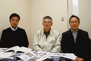 -Dr. Yoshiaki Shimada, Associate Professor -Dr. Etsuo Funawatashi, Professor (Head of Civil Engineering & Environmental Design Course, graduate school) -Dr. Masato Horiuchi, Professor (Head of Dept. of Civil engineering & Environmental Design) |
|
 |
 |
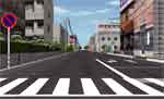
(left: with utility pole (existing conditions), right: without utility pole) |
|
 |
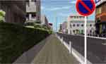 |
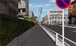
(left: with utility pole (existing conditions), right: without utility pole) |
|
 |
|
 |
|


