
Three-dimensional analysis of slope stability / program for planning countermeasure work
3D slope stability analysis 3DCAD
(LEM) Ver.2
Initial Release: 2004.04.01 / Latest Ver.: 2011.09.12
- 3D slope stability analysis 3DCAD
(LEM) Ver.2 - USD3,360
- Chinese Version
- USD6,720

Electronic
Delivery
3D PDF
Related products and services: Geotechnical analysis support service
Program Overview
Currently it is common to analyze slope stability with two-dimensional plain surface in mind, but this program will enable you to make stability analysis reproducing real land shapes and sliding surface in three dimensions.
The following two types of 3D terrain shapes are available.
(1) Simply reproduce terrain shapes using a 2D operation that inputs a number of cross sections
(2) Use existing DEM data
In the process of countermeasure work it is possible to draw up a plan of piling using three-dimensional deterrent force, with consideration that putting in piles can be easily put into image in a two-dimensional way. Moreover, considering that current standards about a piling plan are intended for two-dimensional deterrent force, this program is designed so that you can make a plan of piling by means of two-dimensional deterrent force as well.
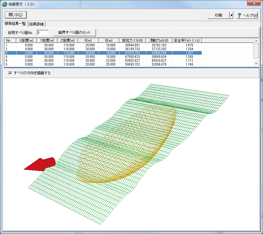
It also supports automatic search assuming the slip surface to be an ellipsoid surface and the ability to set an arbitrary slip direction for the terrain.
The analytic core of this program makes use of the land analysis program by Prof. Ukai and his research laboratory at Gunma University who has reputation for advanced analytic theory and brilliant achievements. It is jointly developed by our company which is engaged in the development of the prepost part and the university.
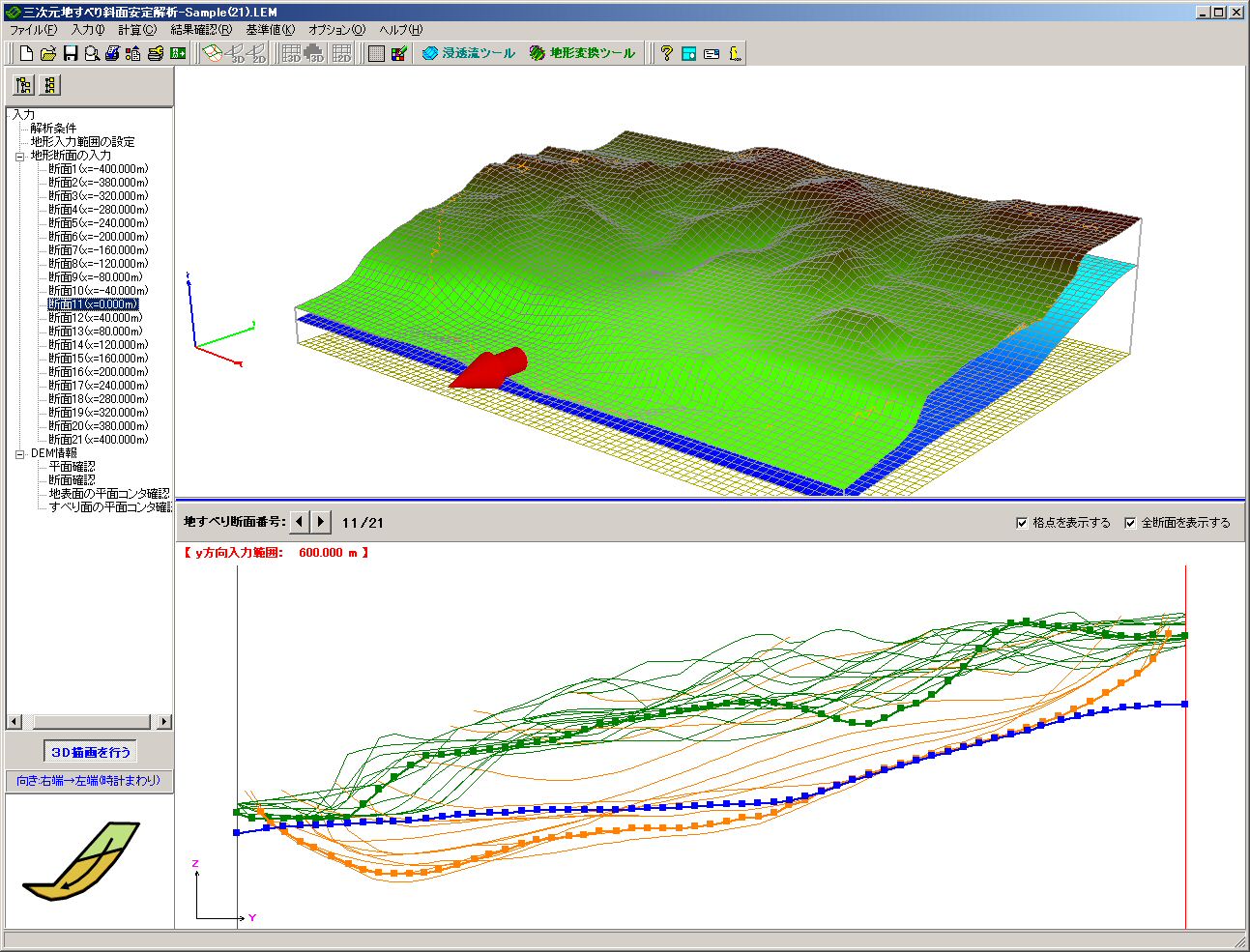
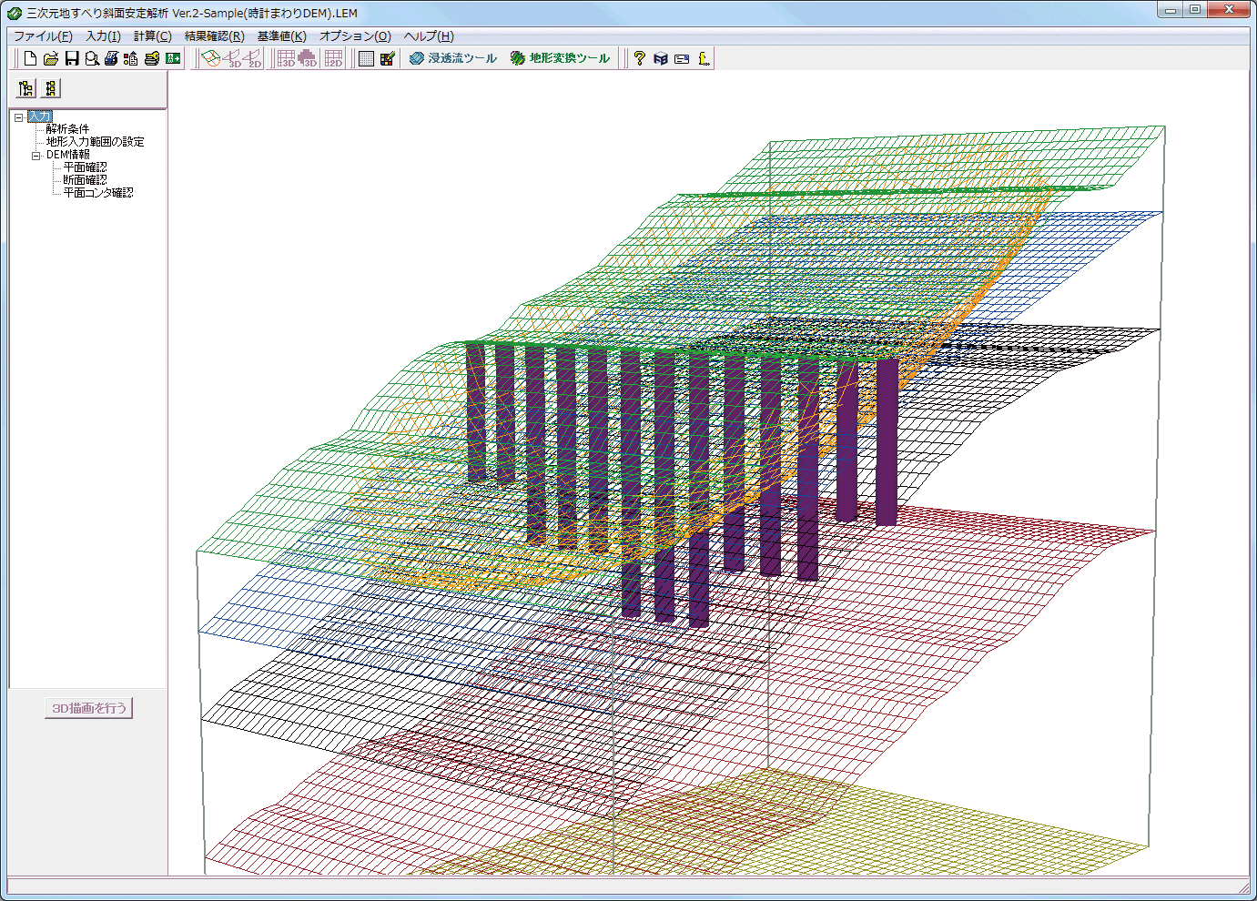
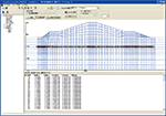
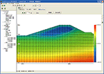
▲ Main window
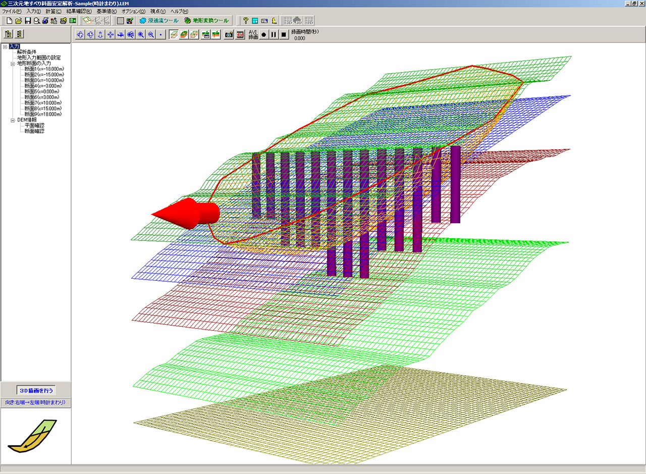
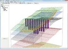
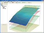
▲ 3D display example (DEM 3D: pile arrangement drawing)
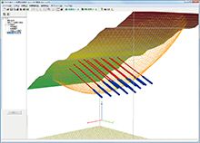
▲ Landslide side auto search
Functions and Features
Analysis methods
-
- Hovland (Hovland) method
- Hovland (Hovland (water weight)) method
- Simple Janbu (The Janbu method)
- Stability factor calculation
- Back calculation method (c is fixed)
- Back calculation method (φ is fixed)
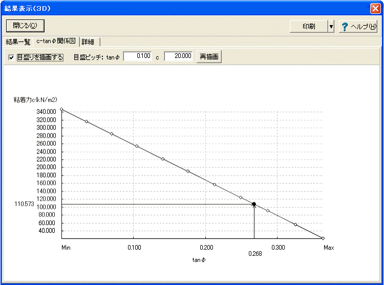
- c-tanφ-related figure
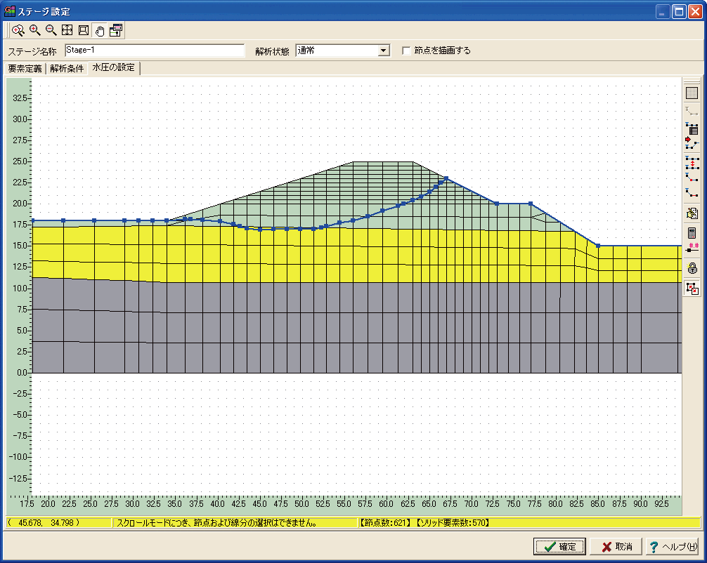
- Arbitrary water pressure can be considered to the landslide side (not the hydrostatic pressure from ground water, but hydraulic pressure examined separately).
- It supports the up and down collective movement of groundwater. (examination of increase in pore water pressure by rainfall and the effect of drainage measure).
- The deterrent of the countermeasure construction is calculated to satisfy the designed safety factor. The safety factor is not particularly described for the 3-dimensional limit equilibrium method, but the 2 dimensions limit equilibrium method in most design manuals. Usually when the 3-dimensional designed safety factor (Fsp(3D)) equivalent to the 2-dimensional designed safety factor (Fsp(2D)) is used, it is necessary to estimate the designed safety factor to be slightly bigger. Therefore, it is suggested that the 3-dimensional designed safety factor should be calculated from 2-dimensional designed safety factor, so the additional function to set the 3-dimensional designed safety factor is equipped with this product.
Analysis methods
(1)Analysis methods: Following 3 methods are available, 2-dimensional limit equilibrium method expanded to 3-dimensional.
Calculation types
Following is available at both all time and earthquake
Additional capabilities
Main analysis, a list of calculation functions
-
Article Detail Analytical methods - Simple Janbu method
- Hovland method
- Hovland (Water weight) methodSafety factor calculation The c φ is input to calculated the safety factor
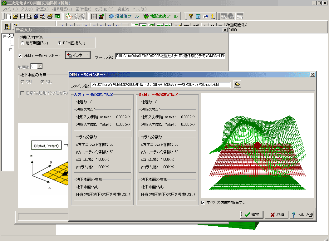
→ requirement deterrent is calculatedTerrain - The number of 2D cross-sections can be input to create 3D geometry.
- Direct input (or import) of DEM data
- Create DEM data from contour figureBack calculation method - The c value is fixed to calculate φ.
- The φ value is fixed to calculate the Co.
- The φ value is fixed to calculate Ck experience value (augmentation factor).
- Making of the c -tanφ-related figureDesign of the countermeasure construction - Design of piles (wedge, shear, and prevention piles) using 3D detents.
- Design of piles (wedge, shear and prevention piles) using 2D detents.
- Stability analysis considering anchor works.Additional capabilities - The 3-dimensional designed safety factor is calculated from the
2-dimensional designed safety factor
- Examination at earthquake
- The consideration of the arbitrary hydraulic pressure on the landslide side
- The up and down collective movement of groundwater
- Direct input and edit of DEM data
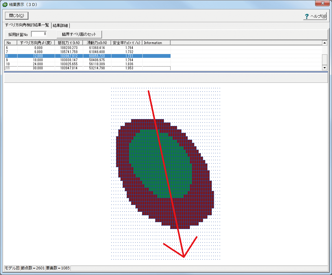
- Automatic search for critical slip surfaces (ellipsoid of revolution surfaces).
- Analysis by arbitrarily changing the slip direction.Tools - SXF data import tool
- Seepage analysis result cooperation tool (SATL3D)
- Terrain model conversion tool (GMTL3D):
BoringCD/3D-Pro (GeoMap3D)→ Section data for LEM
BoringCD/3D-Pro (GeoMap3)→ DEM data for LEM■Processing
Applicability
-
Top items Middle items Sub items Limit Note Land features Number of landslide layers Multilayered ground correspondence 10 number of cross sections (lateral lines) 99 SXF data import CAD data can be read. ○ Components Ground surface 199 Underground water surface 199 Selectable Landslide side 199 Layer border 199 9 surfaces Landslide surface Number of blocks of slip surface blocks (number of physical property pairs) 1 Number of ground surface intersections 2 Beginning and end only Submergence terrain Analysis is carried out to lower the groundwater level forcibly. × Not supported yet Analysis Number of column division Partition numbers to x and y direction 200
About the countermeasure construction design
-
- The design calculation of the pile work by the 3-dimensional analysis (the 3-dimensional deterrent) is available.
- The design calculation of the pile work by the 2-dimensional analysis (the 2-dimensional deterrent) is available at the same time.
- 3 types of piles, "a wedge pile", "a shear pile" and "a prevention pile" are available in the pile work design calculation.
- Examination of the most suitable pile location by the Ru-Ly curve is available.
- As pile arrangement, examination of a single row and a staggered arrangement is available.
▲ Prevention pile
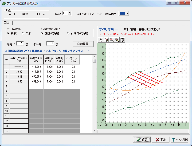
▲ Anchor
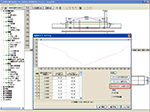
▲ Anchor placing window

Tools (support)
-
SXF data import
Reading of SXF file, which CAD data support as 2-dimensional sectional input tool.
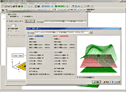
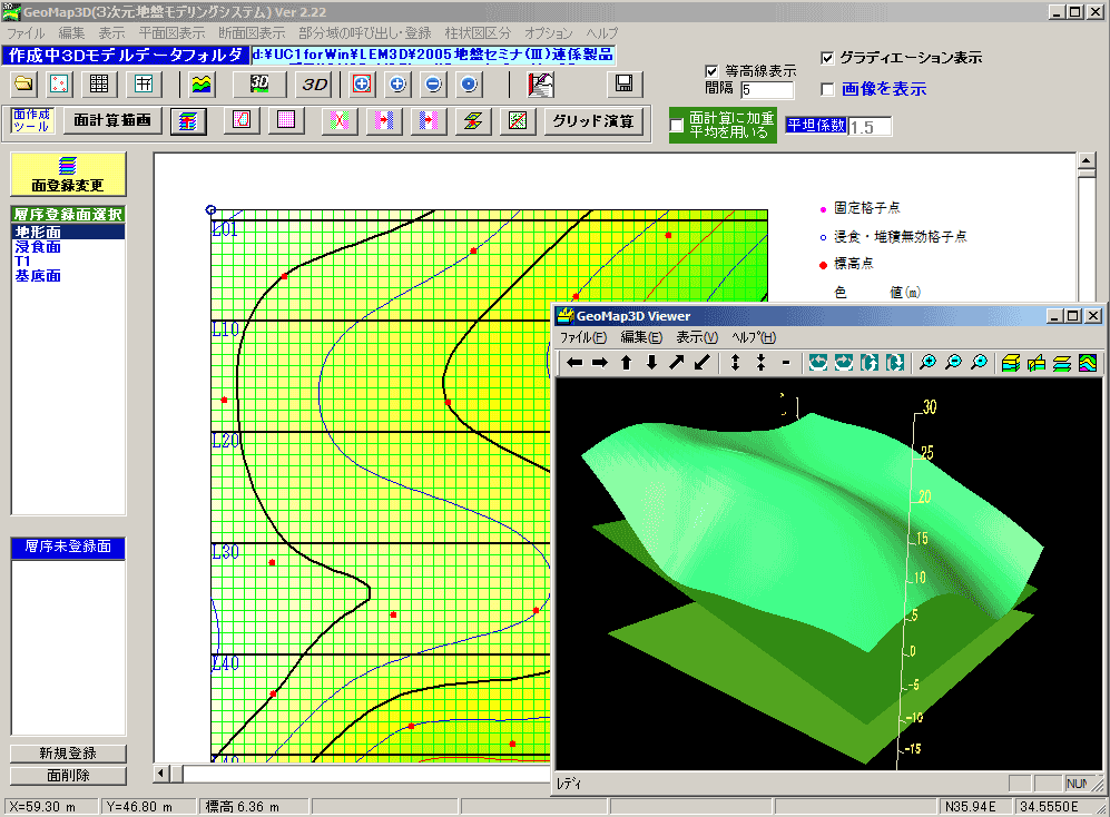
Terrain model conversion tool
The 2-dimensional cross section data or the DEM data that terrain data of BoringCD/3D-Pro (GeoMap3D) was converted into can be imported to this product.
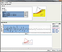
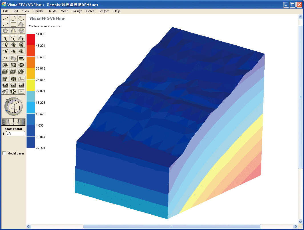
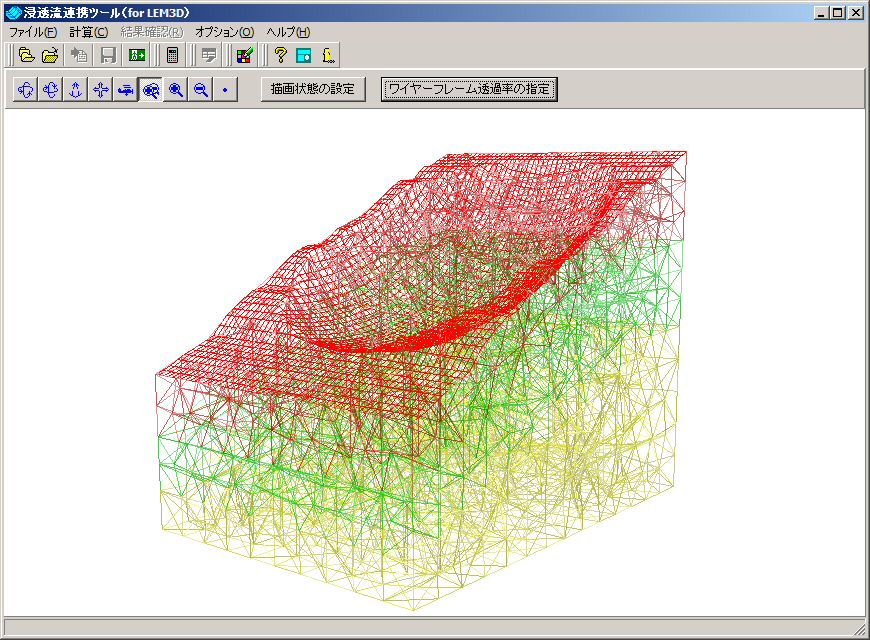
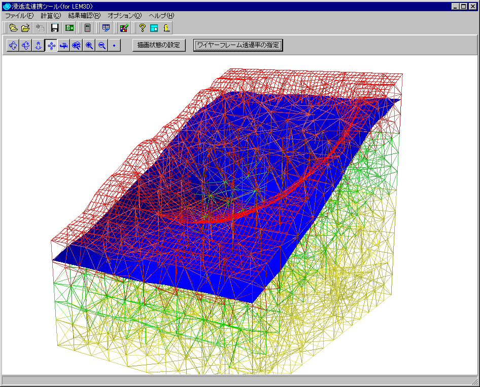
Seepage analysis result combination tool
Slope stability analysis can be carried out, generating groundwater necessary to analyze landslide with our product "3-dimensional Seepage FEM analysis (VGFlow)" or by using of result analysis as regular text format even if it is third parties' product.
▲GeoMap3D terrain convertor,
after conversion (import DEM data)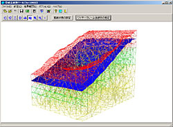
▲Seepage flow results linkage tool which
generates groundwater surfaces.
Drawing, output capabilities
-
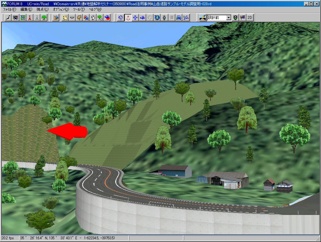
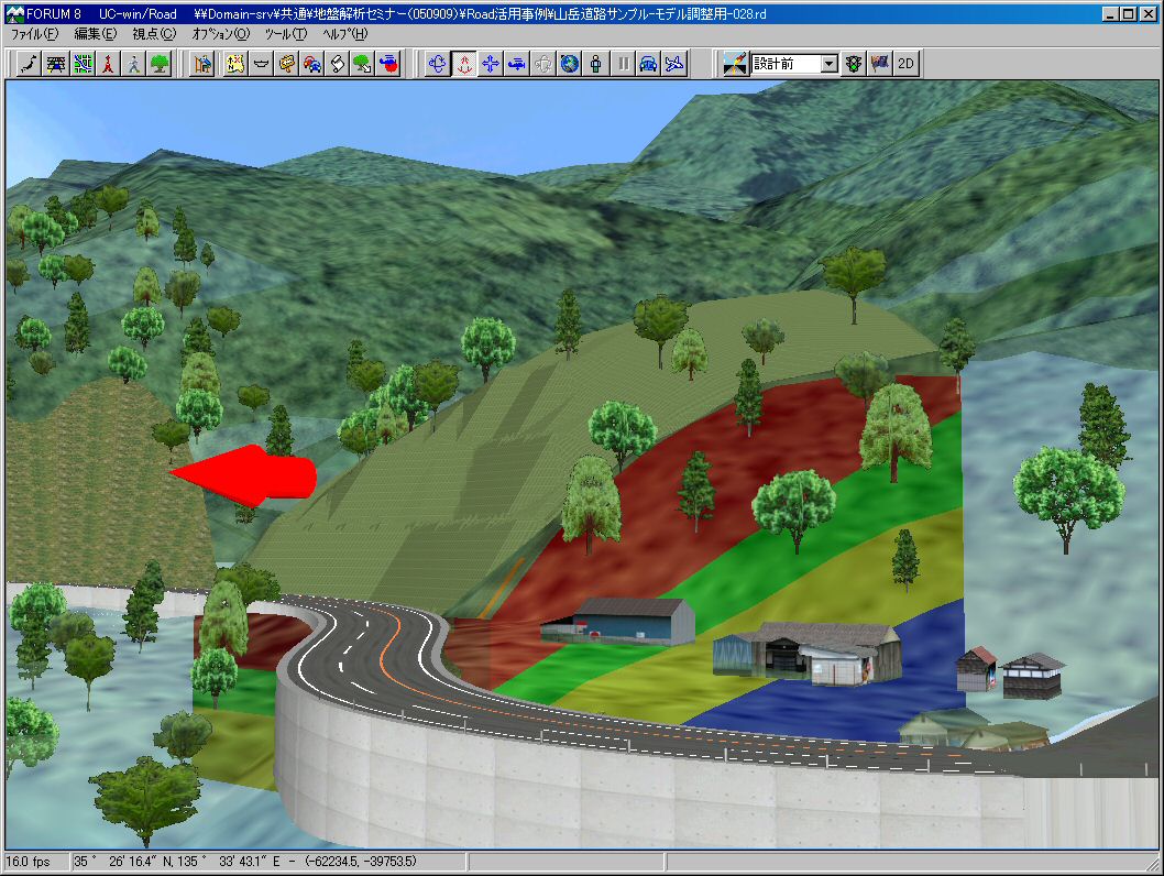
- both "course of traverse type" (Tin type) 3D" and "DEM type 3D" can be displayed by 3D drawing function.It allows 3D models to be exported in 3DS format and imported in UC-win/Road.
- "Thrust vector diagram" and "Maximum shear resistance force figure" are available to be output as the 3-dimensional slope stability analysis result.
- "Ru-Ly curve" and "c-tanφ related figure" can be also output for report.
- Selection of the output from a tree view and an output preview are supported. Printer and HTML output is available with figures in design cases, calculated results. It is convenient for data reuse and computerizing of reports, supporting HTML output and output as text format.
- Contour and 3D diagram drawing of analysis results is also supported.

▲3DS format output, UC-win/Road import (transparent)
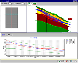
▲Confirmation of DEM cross section
(longitudinal cross-section view + 3D view)
Enhancement of CIM function on the geotechnical analysis series products
-
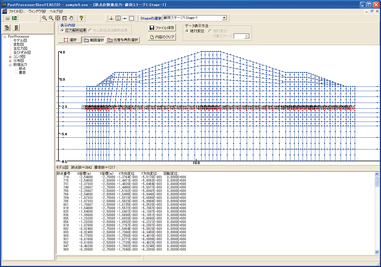
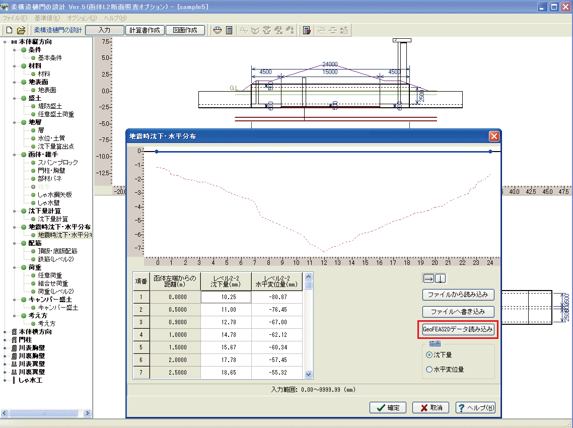
Data linkage using terrain data file (*.GF1) Geotechnical Finite element Elastoplastic Analysis Software (GeoFEAS)2D Ver.3
The amount of displacement imported to Flexible structure sluiceway design for further analysis
By importing results of ground deformation analysis (settlement / horizontal displacement distribution) to the "Flexible structure sluiceway design", the level2 seismic test for the longitudinal direction can be performed.

GeoFEAS2D Flexible structure sluiceway design
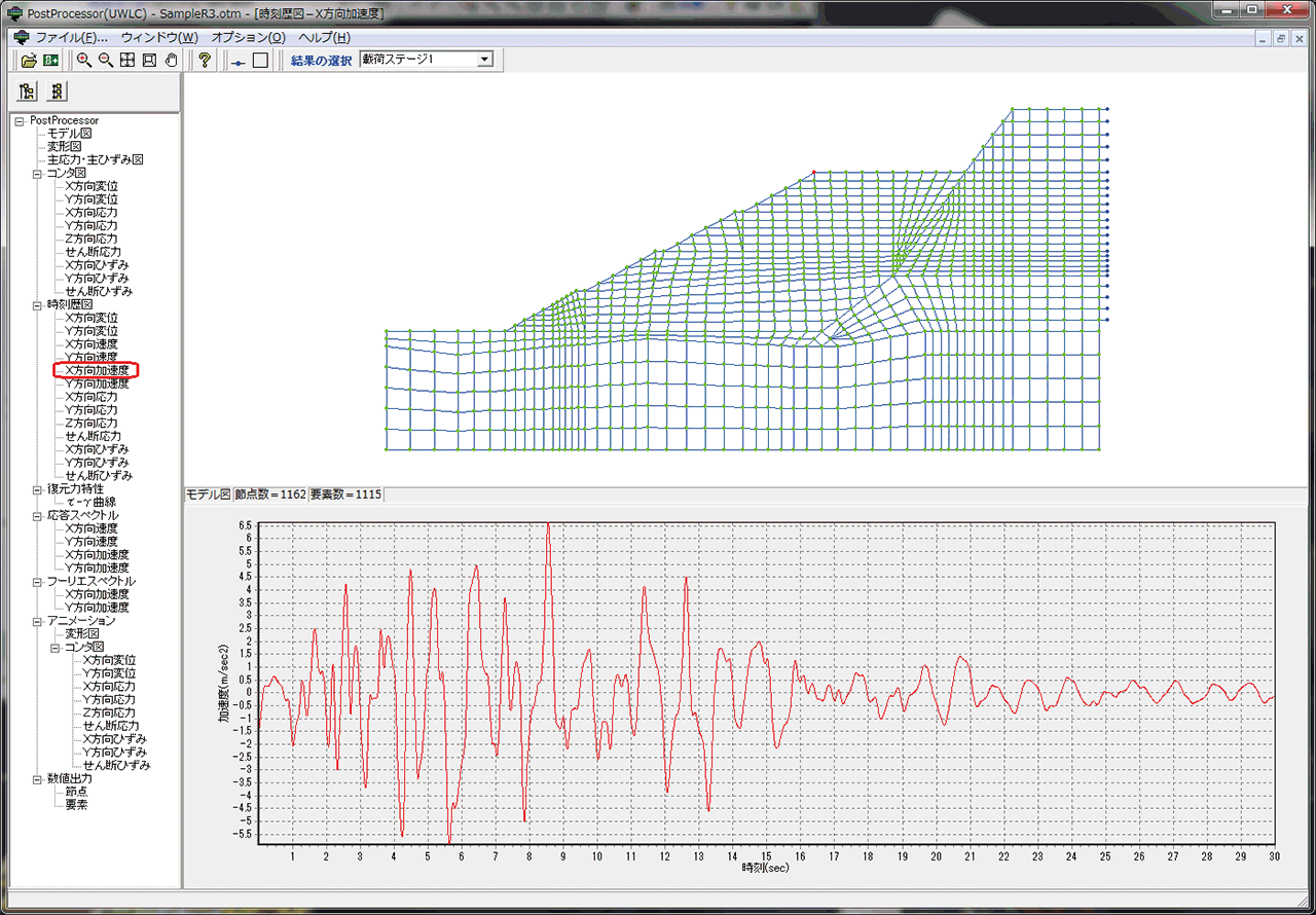
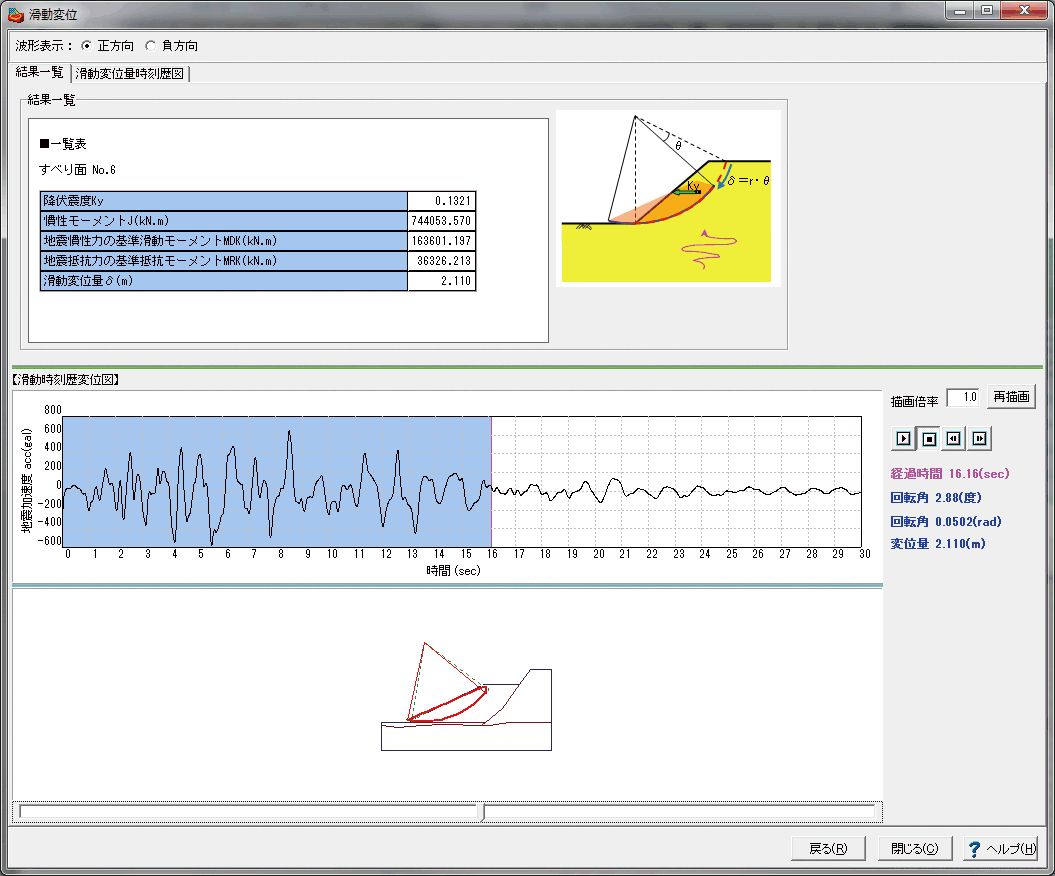
It can modelize only ground that a surrounding ground effect analysis is conducted in the Temporary sheathing work design. The ground deformation can be calculated by giving the wall displacement as the forced displacement.Dynamic effective stress analysis for ground (UWLC)
Acceleration rate imported to Slope stability analysis for further analysis
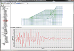
When applying the Newmark method to high embankments with a height of about 30 m or more, it is necessary to input the response acceleration waveform of the slip soil mass as the ground motion.
Data linkage between "Dynamic effective stress analysis for ground (UWLC)" and "Slope stability analysis" corresponds to the Newmark method analysis calculated by using the response acceleration waveform.
The level2 seismic stability calculation for high embankment and large embankment.
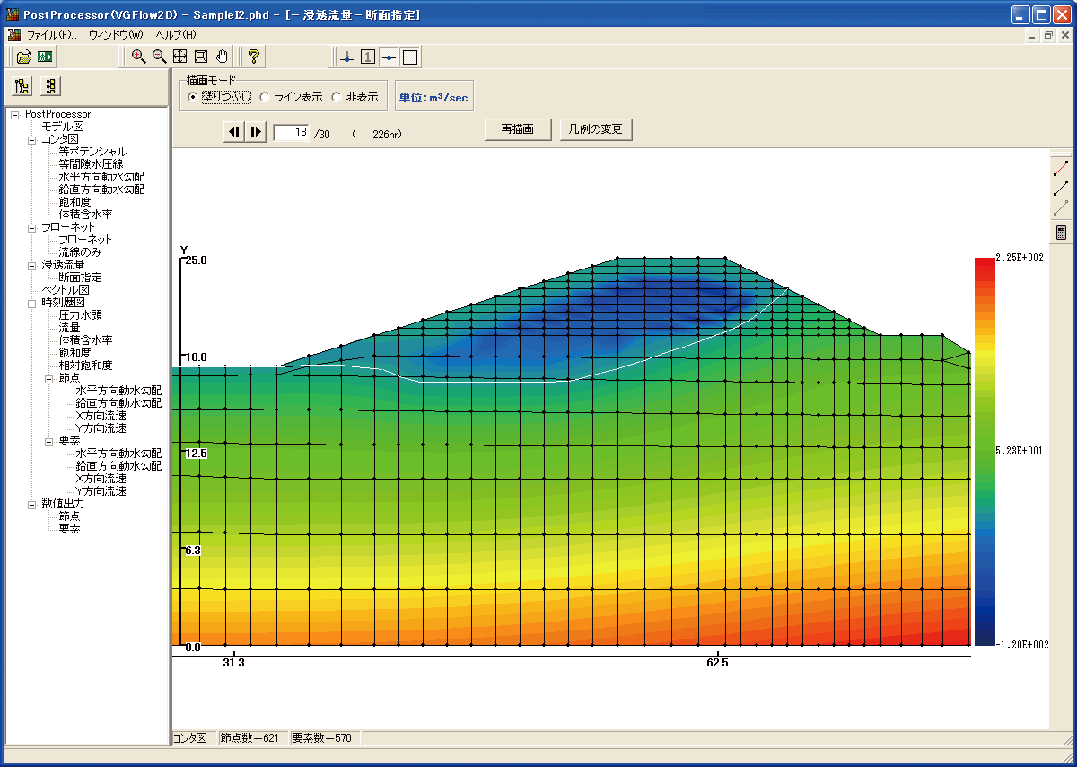
UWLC Slope stability analysis 2-D seepage analysis(VGFlow2D)
Water line data imported to GeoFEAS2D
VGFlow2D GeoFEAS2D
Water level data imported to UWLC
Water line and potential line imported to Slope stability analysis
Saturated / unsaturated seepage FEM analysis results can be reflected by file linkage (*.PRS [water line], *.PTN [isopotential line]).GeoFEAS Flow3D (limited to the seepage analysis)
Water level data imported to LEM3D
Analysis results computed with GeoFEAS Flow3D (limited to the seepage analysis) or third party's product can be imported to 3-D slope stability analysis(LEM). It creates underground water level required for landslide analysis and enables the 3D slope stability analysis.

VGFlow3D LEM3D
Standards, regulations and reference literature
- Application criteria
-
Application criteria (社)日本道路協会 道路土工「のり面工・斜面安定工指針」 平成11年3月
(社)日本地すべり学会 「地すべり鋼管杭設計要領」 2003年6月
- Reference literature
-
- 土木研究所資料第2265号「Hovland法による地すべり三次元安定解析手法」昭和60年11月建設省土木研究所砂防部地すべり研究室
- 「地すべりの三次元斜面安定解析」 平成7年1月 吉松弘行
- 「安定解析におけるせん断強度低減法の有効性」 土と基礎 1990.1 鵜飼恵三
- 「任意形状の地形とすべり面を有する斜面の安定解析」 土木学会論文集 第412号 1989.12 鵜飼恵三、他
- 「簡易Bishop法,簡易Janbu法およびSpencer法の三次元への拡張」土木学会論文集第394号1988.6鵜飼恵三,他
- 「モデル化された切土斜面の三次元安定解析と留意点」 地すべり第29巻 第4号 1993 鵜飼恵三、他
- 「分割法による斜面の三次元安定性の検討」 土と基礎 1988.3 鵜飼恵三
- 「簡易Janbu法による斜面の三次元安定解析」 地すべり第24巻 第3号 1987 鵜飼恵三
- 「簡易分割法による斜面の三次元安定解析」 土木学会論文集 第376号 1986.12 鵜飼恵三、他
- 「粘性土斜面の三次元安定解析」 土木学会論文集 第364号 1985.12 鵜飼恵三
Price
Product Price
-
■Product Price
Product
Price
3D slope stability analysis - 3DCAD (LEM) Ver.2 USD3,360 3D slope stability analysis 3DCAD (LEM) (Chinese version) USD6,720 ■Price of Floating License
Paying 40% of the product price allows anyone to use the product on any PC anywhere in the world.
Product
Price
3D slope stability analysis - 3DCAD (LEM) Ver.2 USD1,344 3D slope stability analysis 3DCAD (LEM) (Chinese version) USD2,688
Price of Subscription Service Contract
Price of Subscription Service Contract
-
■Support information
-Software upgrade -Technical inquiry (Email, Tel)
-Download service -Maintenance and update notifications via email
* We are sequentially making a transition from the maintenance-support service to [Subscription Service] from April 1, 2016 in order to enhance support for diverse product usage and to reduce license management cost.
Product Subscription cost
of first yearSubscription cost
of subsequent years
(annual cost)Subscription (3D slope stability analysis - 3DCAD (LEM) Ver.2) Free USD1,344 Subscription (3D slope stability analysis 3DCAD (LEM) (Chinese Version)) USD2,688 Subscription (3D slope stability analysis - 3DCAD (LEM) Ver.2 Floating) USD1,881 Subscription (3D slope stability analysis 3DCAD (LEM) (Chinese Version) Floating) USD3,763
Price of Rental License / Floating License
■Rental license : Short term licenses available at a low price
■Rental floating license : After web activation, anyone can use the products on any PC anywhere in the world.
■Rental access : You can increase the number of licenses you own and use these additional licenses for a specific period of time (1 month to 3 month) at your discretion. We will later send you an invoice based on your usage log. The advance application is 15% off of the regular rental license price. Please place an order from User information page.
*Rental / Floating Licenses were introduced on September 2007 to enhance user experience and convenience of our products.
*Duration of Rental / Floating Licenses cannot be changed after starting these services. Re-application is required to extend the rental and floating license duration.
Rental license / Rental floating license
-
■Rental License
Product 2 month 3 month 6 month 3D slope stability analysis - 3DCAD (LEM) Ver.2 USD1,512 USD1,780 USD2,184 3D slope stability analysis 3DCAD (LEM) (Chinese Version) USD3,024 USD3,561 USD4,368 ■Rental Floating License
Product 2 month 3 month 6 month 3D slope stability analysis - 3DCAD (LEM) Ver.2 USD2,520 USD2,990 USD3,696 3D slope stability analysis 3DCAD (LEM) (Chinese Version) USD5,040 USD5,980 USD7,392 Academic Price
An Academic License can be provided for educational purposes and used by teachers, lecturers, academic researchers, and students.
Academic Price
-
Product Academic Price 3D slope stability analysis - 3DCAD (LEM) Ver.2 USD1,120 3D slope stability analysis 3DCAD (LEM) (Chinese Version) USD5,376 Version Update History
Version Update History
-
The version upgrade and revision upgrade (without charge) contents are listed as following.
3D slope stability analysis - 3DCAD (LEM) Ver.2 Version Release date Update contents 2.02.00 15/05/29 - Support for contour plotting of analysis results
- Support for drawing 3D diagrams of analysis results
Product Operation Environment
Product Operation Environment
-
OS Windows 10 / 11 CPU Environments that meet the system requirement of the OS and operate without any problems. Memory (including OS) Environments that meet the system requirement of the OS and operate without any problems. Disk capacity About 60MB or more (for installation and operation) Display (image resolution) 1024×768 or greater Extension for input data LEM File export For F8 Export Editor Tool: TXT, HTM, PPF, DOC, DOCX, PDF, JTD, JTDC
Image: 3DSLinkage to other products <Save> UC-win/Road (3DS)
Order / Contact Us
Order / Contact Us
-
■ Inquiry
Contact us from Sales inquiry or email to ist@forum8.co.jp or forum8@forum8.co.jp
Samples
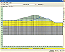
▲ Main window
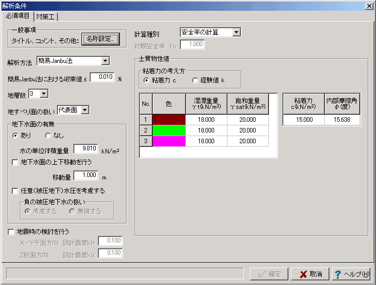
▲ Analysis conditions

▲ Setting of the terrain input area
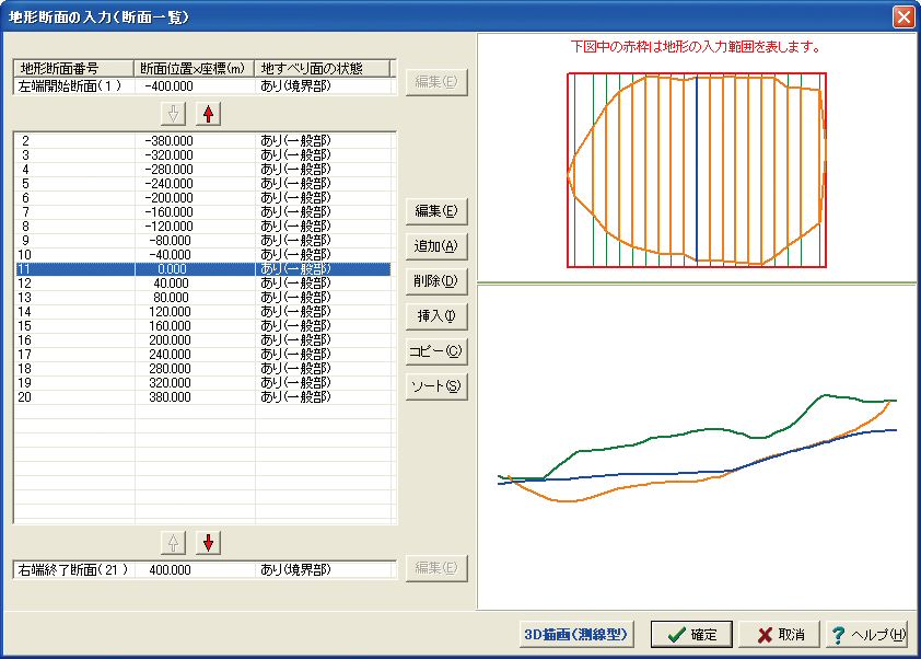
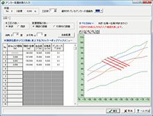
▲ Input window of terrain section
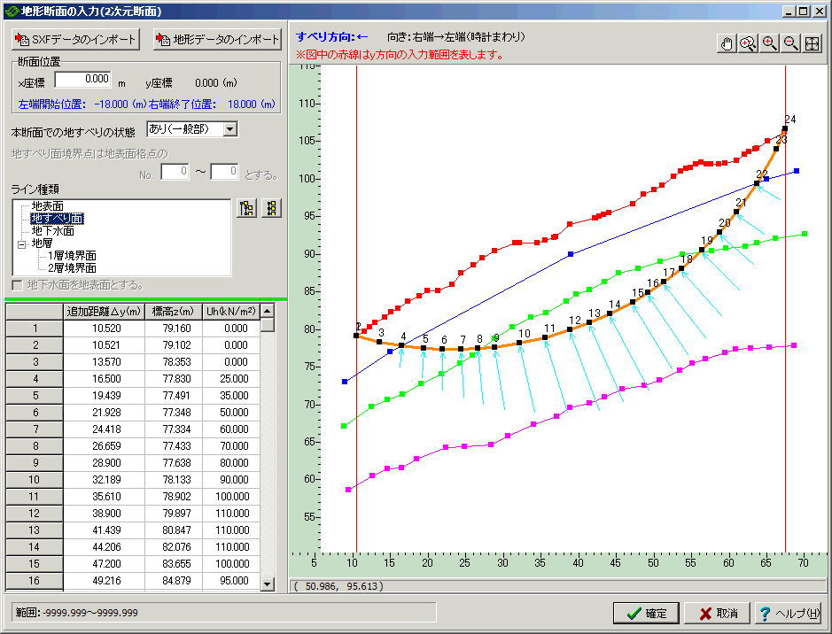
▲ Input of terrain cross section
(including input of arbitrary water pressure strength)
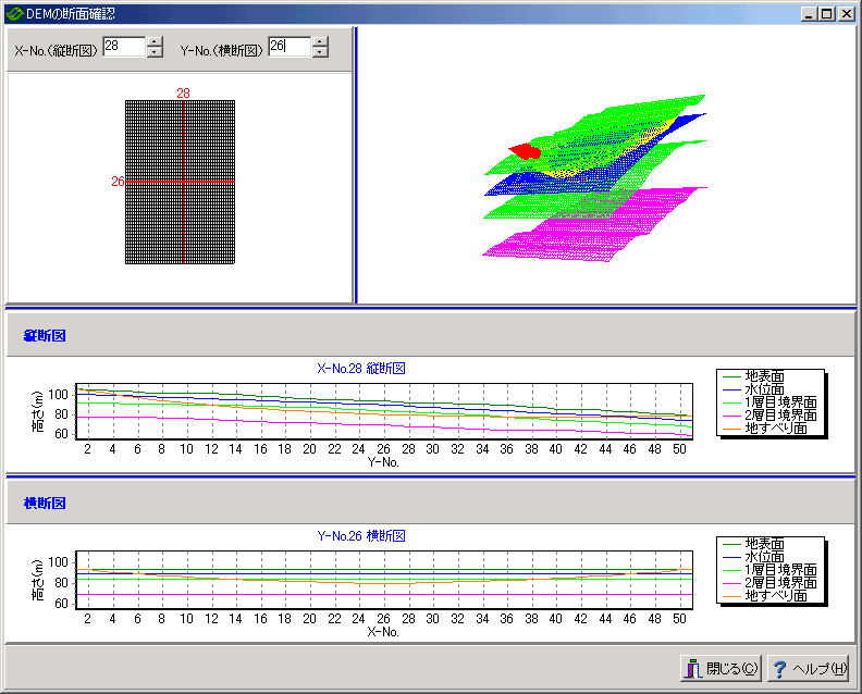
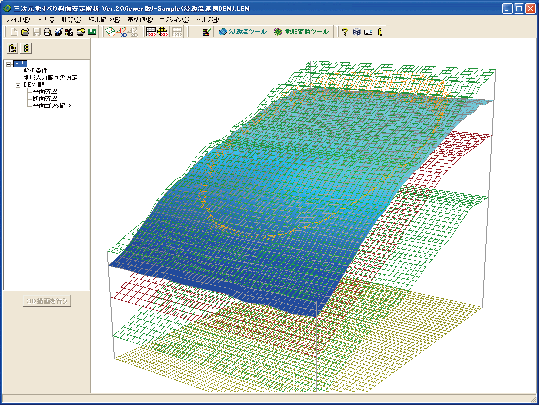
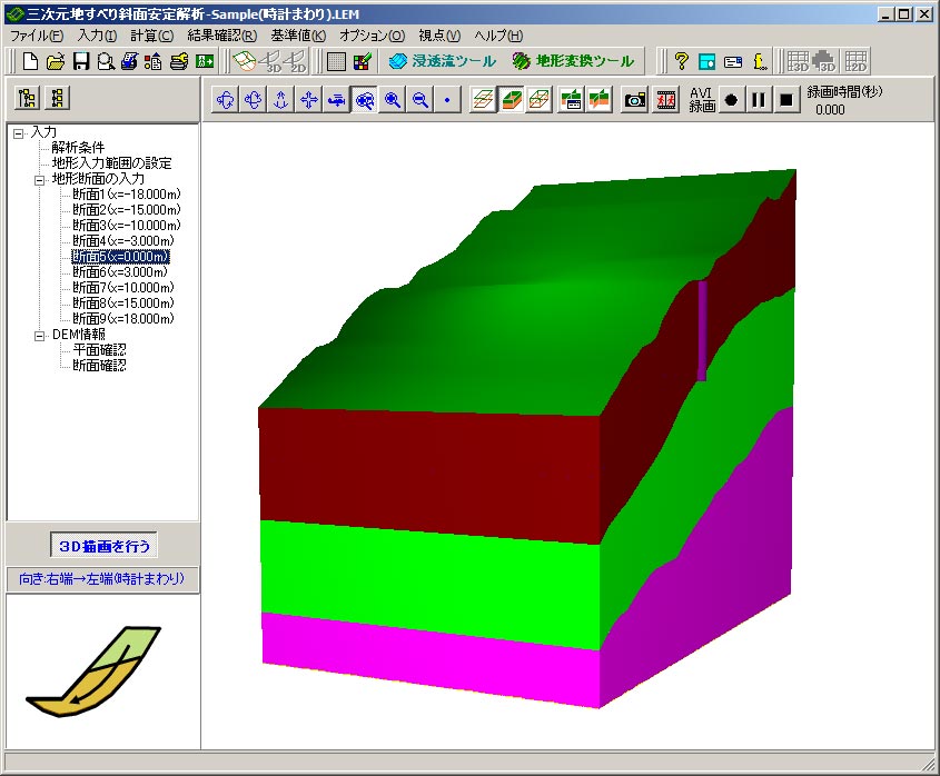
▲ Confirmation of DEM cross section
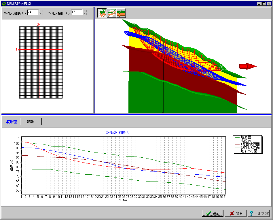
▲ Confirmation of DEM cross section
(Longitudinal cross-sectional view + 3D display)

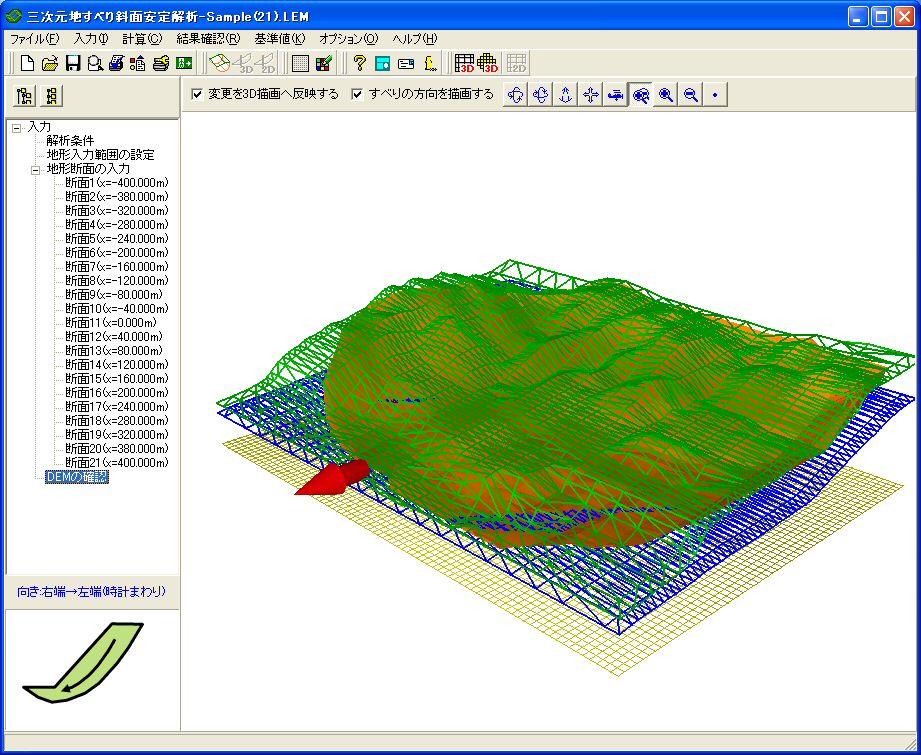
▲ 3D display example
(DEM type 3D: Ground surface wireframe)
▲ 3D display example
(Geodesic 3D: ground surface wireframe)
▲ 3D display example
(Fill strata side)
▲ 3D display example
(DEM type 3D: Pile layout diagram)
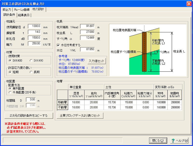
▲ Pile work design calculation
(design condition)
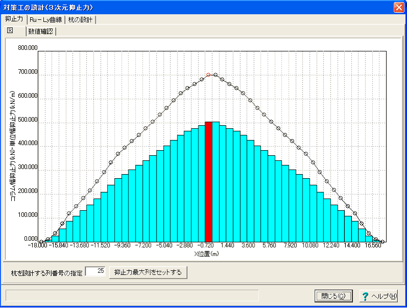
▲Pile work design calculation
(deterrence distribution chart).
▲Pile work design calculation
(Ru-Ly curve diagram)
▲ Automatic slip surface search
▲ Consideration for arbitrary slip directions
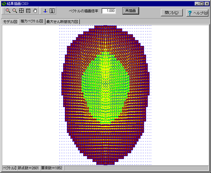
▲ Result confirmation (Thrust vector diagram)
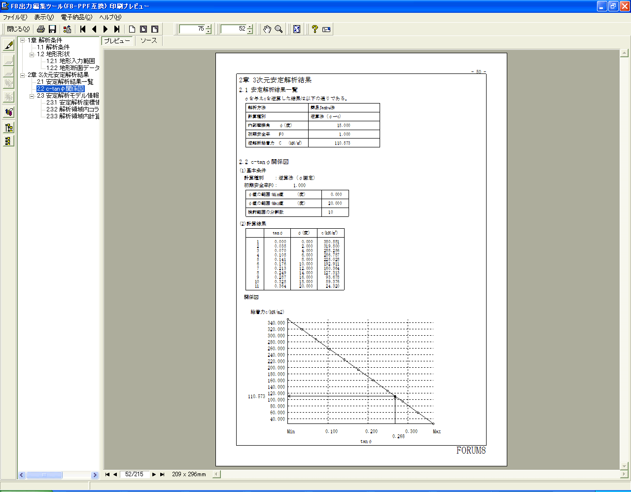
▲ Print preview
▲ 3DS format output
▲ 3DS format output,
UC-win/Road import (nontransparent)
▲ 3DS format output,
UC-win/Road import (transparent)
▲ Seepage flow results linkage tool
(import of analysis result)
▲ Seepage flow results linkage tool
(creation of underground water surface)
▲ GeoMap3D converter, source
(OYO Resources Management Co.ltd.)
▲ GeoMap3D terran converter,
after conversion (import of DEM data)

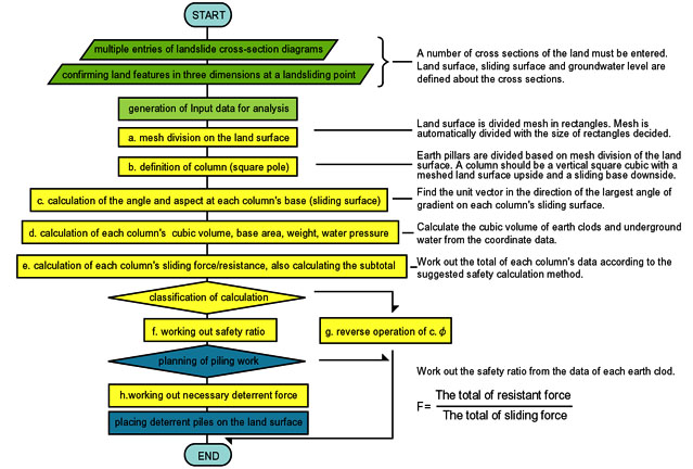
LOADING