 Product Overview Product Overview
 |
|
UC-win/Road optional tool "UC-win/Road Data Exchange Tool" is a tool collection that helps to create the data of 'UC-win/Road', such as DXF data exchange, SIMA data exchange, 3D model creation and exchange.
The following tools are provided in the product.
|
|
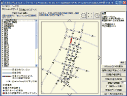
 Transportation Census Transportation Census VR Simulation Data Development Tool Transportation Census Transportation Census VR Simulation Data Development Tool
(Under development) |
This is the program that enables road traffic census information (CD version, traffic engineering research group) to be set for traffic volume, profile in UC-win/Road.(on the right above)The traffic amount for weekday, holiday, daytime, night time, and a peek of the rush hour for each route can be set visually. The profile for each vehicle type also can be set automatically.
In addition, weight adjustment function is supported. |
 |
|
 Related information Related information |
 New product introduction New product introduction
|
|
|
< Ver.1.04.05 (released in 06 May, 2010) Updated informations >
- Road Data Viewer:
- 3D-PDF report(Output via Acrobat3D V8、Acrobat 9 Pro Extended)
- UC-win/Road 3.04 data format
- EXCEL 2007 User interface
- OpenOffice.org 3.1 report format
- Support for HTML format for each tools
- Support for Web authentication
|
|
Embankment edge 3D model creation tool
|
|
This program is a tool that creates 3D model based on 1/4 cone type of the road embankment edge which is seen at both ends of the bridge. 3D model created with this tool can be imported into UC-win/Road, and be aligned on the embankment edge.
This tool allows to create the embankment edge model easily while imaging the shape by defining each dimensions though some road embankment edges have complex shape with inclination, banking berm position, and crossroad bevel. |
|
Civil engineering 3D model creation tool (Frame)
|
|
This program allows to create 3D model and export them to 3D Studio files
(*.3ds) by defining the model frame, and adding the information to the
frames.
 Main features Main features
- It allows the definition of model's frame in 3D coordinates. Template input
(e.g. arch bridge and truss bridge) and arbitrary coordinate input can
be available.
- The frame is developed by assigning the section configuration for each
element which consists of the frame. After which the 3D shape can be created.
- The template input (rectangle, trapezoid, circle, oval, T digit, box girder,
and hollow digit) and an arbitrary shape input can be available. It allows
you to combine these shapes for the complex section.
- 3D figures can be smoothly edited by activating "3D model exchange
tool", and exporting 3D model directly into it.
|
|
Civil engineering 3D model creation tool (Parametric)
|
|
This program allows the creation of a 3D model by entering the parameters
for each structure, and exporting it as a 3D Studio file (*.3ds).
Main features
- 3D model can be created in a short time as 3D data is generated internally
by entering dimensions for each structure.
- The following civil structural objects are supported.
- Abutment
- Pier
- Retaining wall
- U-shaped retaining wall
- BOX culvert
- The created 3D model can be exported into 3D Studio file(*.3ds).
- 3D graphic can be smoothly edited by activating "3D model exchange tool", and exporting 3D model directly into it.
|
|
Road Data Viewer
|
|
This is the viewer program of the UC-win/Road data file. UC-win/Road data
file (*.rd) created in "UC-win/Road" is imported, and the information
of each aligned object is referred. The detail of the imported UC-win/Road
data file(*.rd) can be verified.
Main features
- The status of the imported UC-win/Road data file can be viewed on the plane.
- The following validation function can be available for the imported UC-win/Road
data.
- Verification of repetition arrangement
If the same kind of object is located in the same coordinate with the same scale, it is detected and listed.
- Verification of outside range arrangement
If the object is located out of the specified region when the terrain data is imported, it is detected and listed.
- Search by specifying the upper/lower limit value of the bit map size
The upper/lower limit value of the bit map size is specified, and then the texture, street map (picture) is searched, and listed.
- Search by specifying the upper/lower limit value of the polygon number.
The upper/lower limit value of the polygon number is specified, and then 3D model list is searched, and listed.
The position of the object in the verification result can be specified by activating "UC-win/Road".
- Report can be generated by using Excel template.
- Basic linear input can be listed by using Excel template.
- Terrain patch file(*.xml)to be imported in "UC-win/Road" can be created.
|
|
Page Top  |
GeoMap3D Data exchange tool
|
|
This program allows to exchange the layer data (*.dat) group exported from
"Geomap 3D" of Oyo Resources Management Co., Ltd into the terrain patch
file (*.xml), the digital altitude data file (*.DEM), and 3D Studio file
(*.3ds) of 'UC-win/Road'.
Forum8's related product:BoringCD/3D-Pro(GeoMap3D) 3D terrain modeling
software (Japanese)
Main features
- The imported data is loaded as the terrain layer, and the terrain layer
shape can be viewed in solid and wire frame.
- The whole terrain layer or each terrain layer data can be exported as a
3D Studio file(*.3ds). Note that the section cannot be exported if you
have selected to export per layer.
- The exported 3D Studio file (*.3ds) can be imported into our product "UC-win/Road"
or the other programs that support 3DS format.
Export format
- UC-win/Road terrain patch file(*.xml)
- Digital terrain data file(*.DEM)
- 3D Studio file(*.3ds)(the entire file or solely the selected layer)
|
|
SIMA Data exchange tool
|
|
This program allows the exchange of the road linear and the road cross-section
information described by "Survey data common format" (Abbreviation:
SIMA common format) into the data file (*.rd,*.rs,*.xml) to be imported
in "UC-win/Road".
SIMA File
The following versions of SIMA common format(*.sim)are supported.
Data exchange
- Route data
Route data with same group number is exchanged by the following selected route type. The route date with group number 0 can be exchanged separately.
- IP line (Straight line only)
- Main line (Including curve)
- Center line (Including curve)
- Width pile line left (Straight line only)
- Width pile line right (Straight line only)
- Continuous linear (Straight line only)
- Continuous linear (Including curve)
- Longitudinal result data
Longitudinal result data is exchanged only when the selected route data is exchanged,
- Cross section center information data, Cross section result data
Cross section center information data is exchanged only when the selected route data and the longitudinal section result data is exchanged.
The cross section result data is individually exchanged.
- Terrain data
Terrain data that lies at least 1000m from the edge of the terrain extent
can be exchanged.
Check the display of the horizontal alignment
The display equivalent to "Road plan view" screen of "UC-win/Road" can be displayed.
Edit the road section
The road section can be edited in this program.
Export
It allows the export of the following data files.
The data file version to be exported is equivalent to UC-win/Road Ver.2.00.00.
- UC-win/Road data file(*.rd)
- UC-win/Road road section file(*.rs)
- UC-win/Road terrain patch file(*.xml)
|
|
3D model exchange tool
|
|
This program allows the file import of a variety of formats, and conversion
into 3D Studio file (*.3ds).
Main features
- Import
- UC-win/Road 3D model file (*.rm)
- UC-win/Road terrain patch file (*.xml)
- AutoCAD 3D model file (*.dxf)
- 3D Studio file (*.3ds)
- Edit the model
- Change the scale(0.01 ~ 100.00 times)
- Rotate X/Y/Z direction(-360.00 ~ 360.00 degree)
- Move X/Y/Z direction (-100.00 ~ 100.00 m)
- Change the parts name
- Integrate to the new parts
- Invert the polygon in the vertex order
- Delete the parts/polygon
- Check the display
- Display the model construction
- Highlight the selected polygon
- Display/Hide per parts
- Change the alpha channel
- Change the parts color
- Select the both side of drawing of polygon
- Edit the material
- Change the material name
- Create the new material
- Delete the material
- Edit the writing attributes
- Setup the environment
- Display color
- Grid divided number
- Highlighted line width
- XML sort space
- Export
|
|
DXF Data exchange tool
|
|
This program allows to exchange the DXF file (*.dxf) such as the terrain features into the terrain patch file (*.xml) that can be used in "UC-win/Road".
DXF File
DXF file(*.dxf) is imported and exchanged to the coordinate data per layer. The exchanged coordinate data can be exported to the terrain patch file(*.xml)per layer. The table below shows the ENTITY section supported to be exchanged with this program.
| |
3DFACE |
3DLINE |
LINE |
POINT |
| VERTEX |
POLYLINE |
CIRCLE |
ARC |
| ELLIPSE |
TRACE |
SOLID |
SPLINE |
| INSERT |
LWPOLYLINE |
|
|
Edit
The imported data can be referred and edited per layer.
XML Export
DXF file is exported into the terrain patch file (*.xml) per layer.
Setting of the export can be changed by each option.
The exported terrain patch file can be re-imported and edited |
|
Horizontal alignment IP calculation tool
|
|
This program allows to calculate the IP point required for defining the
road in "UC-win/Road" when the turning point of road is given
in the horizontal alignment from a linear statement.
Main features
- IP point can be calculated from the turning point of the horizontal alignment.
- UC-win/Road's data file(* rd) can be created.
Support for "UC-win/Road" Ver.2.00.00.
- The plane shape of the calculated linear can be checked.
|
|
Tunnel cross section calculation tool
|
|
This program allows to calculate the cross section shape of the tunnel
based on the NEXCO's standard, and convert them into the road section data
file (*.rs) to be imported into "UC-win/Road".
Main features
- The each point coordinate of the tunnel section to be used in UC-win/Road
are calculated based on the idea of Japan Highway Public Corporation 'Design
Scheme -third collections' -"The ninth volume, Tunnel".
- The road section data file(*.rs) to be exported supports "UC-win/Road"
Ver.2.00.00.
|
|
| Page Top |