Service overview Service overview

|
|

The system predicts inundation area and its water depth caused by possible
Tsunami by using the difference method of Shallow-water theory. It also
evaluates wave power, calculates drift carrying capacity, the wave height
and the velocity at mesh points and generates distribution map of tsunami
wave height. |
|
Planned to link with UC-win/Road |
|
|
|
 |
UC-win/Road Ver.5 |
UC-win/Road xpswmm plug-in Ver.2 (for Tsunami) $3,000 (+tax) |
- Tsunami reproducing function by 3D Virtual Reality UC-win/Road
You can set the position, range and height with a visual option as well as tsunami generation by linking with xpswmm.(Japanese)
>> Public sector solution: Tsunami Analysis Service
 |
|
 |
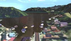
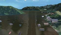
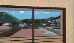
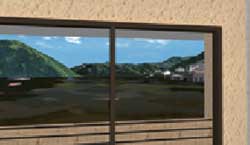
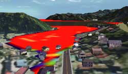
 Simulation result by xpswmm Simulation result by xpswmm |
|
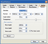
Screen for setting Tsunami |
|
|
|
 Mechanism of tsunami generation Mechanism of tsunami generation |
|
| If an earthquake occurs, the uplift or subsidence is caused by ground movement
under the sea bottom. With this movement, the overlying water vertically
displaced, and the spread of water generates tsunami. When tsunami warning
is announced, ships inside port go out of the port to avoid tsunami strike.
That is because the energy of tsunami is smaller due to the deep water
compared with shallow water area. The word tsunami derives from the larger
damage on ships in the port (=tsu) compared with that of offshore. Currently,
the word "tsunami", is also used in English. The velocity of
tsunami is obtained by multiplying the gravity by water depth and rooting
the value(v=√gd). If the water depth is 4000m and the velocity of tsunami
is approximately 720km/h(200m/S). It almost ties that of jet airplane. |
|

image of tsunami occurrence |
|
|
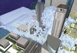
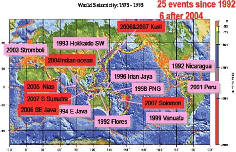
Recent tsunami devastated areas |
|
 |
 |
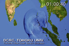 |
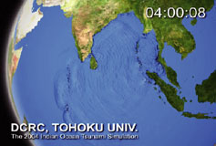
| Animated simulation of the 2004 Indian Ocean Tsunami disaster |
|
|
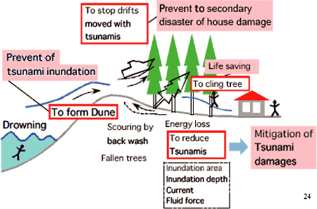
Several functions of coastal forest in Japan (Hamada & Imamura,2003) |
|
|
|
Tsunami analysis case |
|
- Overview
Numerical calculation of tsunami at Imamura laboratory adapts the difference
method of shallow water theory. As for tsunami simulation, the laboratory
conducts run-up simulation which predicts inundation area and its water
depth caused by possible Tsunami. Through the calculation, It evaluates
wave power, calculates drift carrying capacity, the wave height and the
velocity at mesh points and generates distribution map of tsunami wave
height. Information on submarine topography includes documents published
by Japan Coast Guard.
- Input condition etc.
The condition to be entered includes epicenter information (magnitude,
dept and position) and submarine topography data (altitude and position).
- Analysis sample case
This is the case of Fukushima Earthquake, which occurred July 19th, 2008.
Magnitude of the earthquake: M=6.6, depth of epicenter: about 10km.This
case shows that the result of analysis is close to the estimation of meteorological
agency, while the arrival time is 20 minutes later than that of meteorological
agency.
|
|
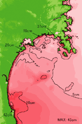
distribution map of maximum tsunami wave height |
|
|
Link with Tsunami analysis code of Imamura laboratory |
|
FORUM8 will start analysis support service and make a link between the
analysis code and UC-win/Road, by using the code developed by the laboratory.
The analysis code can be adopted to the creation of hazard maps and the
forecast of tsunami evacuation.FORUM8 is going to start a new service below.
| Tsunami analysis code support service |
The service reduces the load of data entry by transferring the basic data
of topography, buildings, trees and etc from UC-win/Road.
After importing the calculation result of the analysis code, UC-win/Road
visualizes the analysis. |
|
|
Research activity at Imamura Laboratory of Tohoku University |
|
Tsunami Engineering Laboratory (Professor Fumihiko Imamura) studies Tsunami
and the followings are its research activities.Natural disaster is caused
by the interaction between natural phenomena and human society. Damage
phase is constantly changing depending on the evolving civilization. Developing
countermeasures against tsunami disaster is one of the significant issues
for coastal communities, which has been realized to be more important especially
after the 2004 Indian ocean tsunami. The Tsunami Engineering Laboratory
in DCRC, Tohoku University is the only one laboratory that studies tsunami
disasters based on engineering approach. Based on the philosophy of prevention
and control, their research focuses on field research work in Japan and
abroad, development of prediction system based on numerical modeling technique
and support for disaster prevention activities in local community. Especially,
TIME (Tsunami Inundation Modeling Exchange) project is representative of
our efforts, which transfers numerical modeling technique to more than
7 countries and communities at risk. The project is supporting the reconstruction
and disaster prevention activities in the tsunami damaged countries. |