UC-win/Road plugin to visualize Debris-Avalanche simulation and analysis results
Debris Flow Plugin Option Ver.3
Initial Release:2012.12.13 / Latest Ver.:2020.10.20
- USD3,360
Program Overview
Landslide and debris-avalanche occurs frequently in Japan due to its weak geological formations and topography not to mention its steepness. Debris-avalanche does more damage to the people than it does to the land itself. In fact, the scale of damage it can cause is extremely large.
One of the effective hard measures to prevent or mitigate the damage that a debris-avalanche can cause is building a check dam. The soft measures are establishing means of information transmission or an organized warning and evacuation system that provides simultaneous announcement to all the residents at risk telling them to evacuate immediately. Other soft measures include regulating the relocation of houses to the areas prone to the disaster and relocating the existing houses to a safer place.
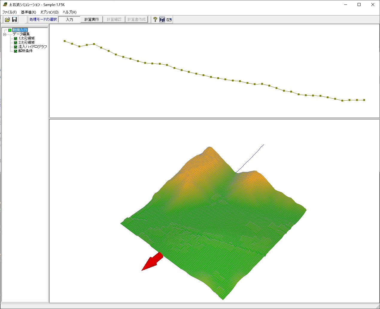
The "UC-1 Debris-Avalanche Simulation" links the "UC-win/Road Debris-Avalanche Simulation plug-in", a solution with an ability to run a debris-avalanche analysis through a series of process, and 3D Visual Interactive Simulation & Modeling software UC-win/Road for creating the input data to be analyzed and visualizing the analysis results within the UC-win/Road 3D VR environment. The UC-1 Debris-Avalanche Simulation uses "Debris-Avalanche Simulator (Kanako)" developed in the Graduate School of Agriculture, Kyoto University, as a solver. FORUM8 has built the robust function that pre-processes and post-processes the data to be analyzed so that a debris-avalanche analysis can be run effectively in a series of process while incorporating the solver, and that' s how this intelligent solution named UC-1 Debris-Avalanche Simulation came to be. The structure and work flow of the system are illustrated below.
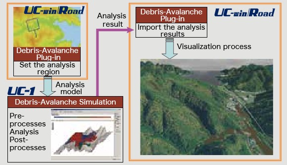
▲System overview
Related Information
- ◆New Product Information
- Debris Flow Simulation Plug-in option Ver.3 (Up&Coming’20 Fall issue)
Ver.3.0.0 Updated Contents (Released on October 20, 2020)
- 1. Automatic calculation of hydrograph using rainfall intensity and UC-win/Road terrain data
- 2. Import of LandXML file
- 3. Data cooperation with Sediment Control Dam Design 3DCAD
- 4. Batch setting of river width
- 5. Setting of coordinate value of fixed floor and moving floor
- 6. Expanded the number of grid points in the 2D area in the plugin from 200x200 to 300x300.
UC-win/Road Debris Flow Plugin Option
Overview
-
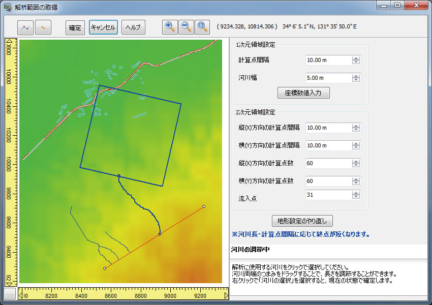
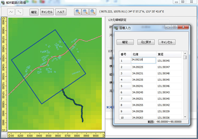
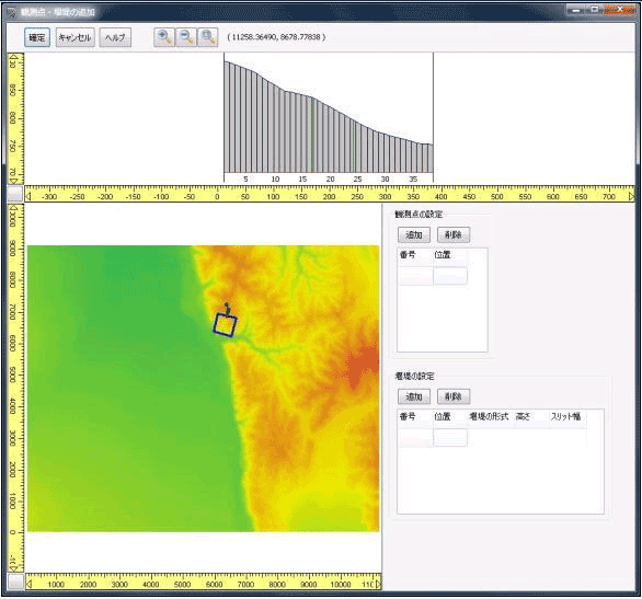
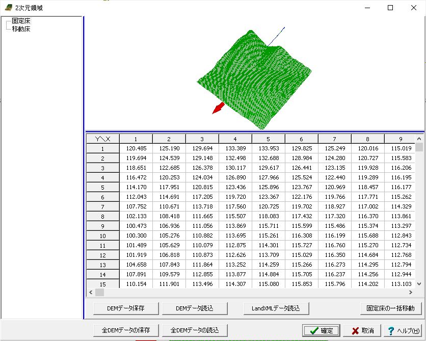
This plugin enables the export of 1 dimensional and 2 dimensional region (terrain) subject to an analysis by the UC-1 Debris-Avalanche Simulation, from the UC-win/Road model. The UC-1 Debris-Avalanche Simulation imports this area for the analysis, and from there on the user can assign several critical conditions to allow simulation to take place.
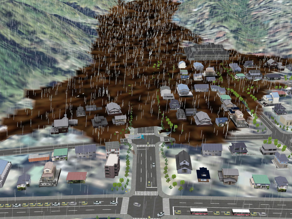
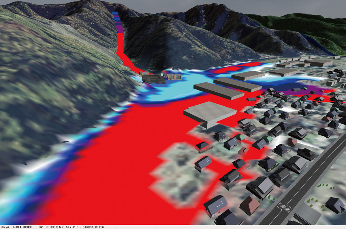
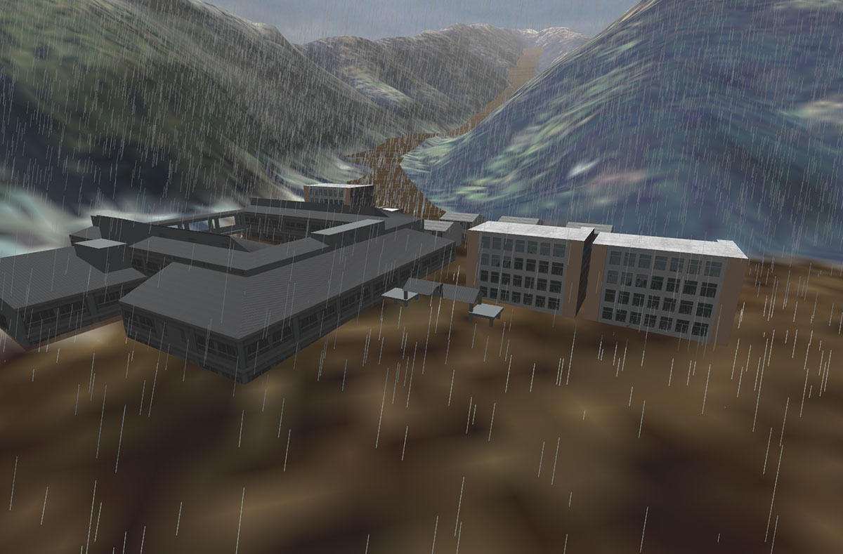
Furthermore, the result analyzed in the aforementioned software can be imported to UC-win/Road using this plug-in for a time-history representation of the approaching debris-avalanche within the 3D VR environment allowing users to visually confirm how sand, mud, and debris travel over time. This system that accurately visualizes the debris-avalanche is not only an effective tool for validating the proposed measures for preventing or mitigating the damage likely to be inflicted by a debris-avalanche, but is also a powerful tool capable of building a risk awareness model that would help the residents to better understand the risk and the actual situation in an event of a large debris-avalanche.
Features
-
This product runs as a plug-in of UC-win/Road and is equipped with the functions below that have been developed by using the engine of mudslide simulator "Kanako" as a reference.
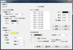
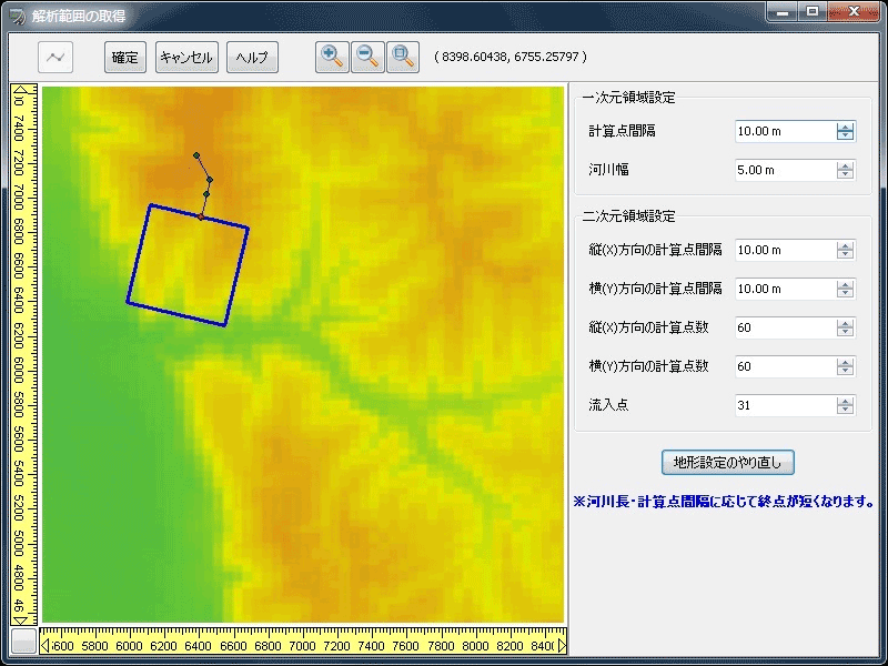
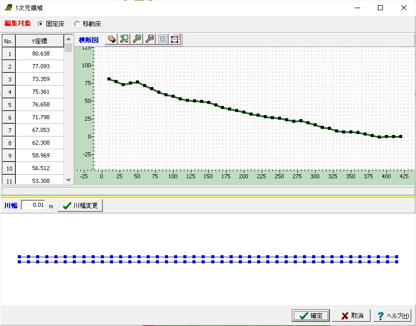
Auto calculation of river
As for model creations of the debris avalanche using the debris flow simulator (Kanako), it is necessary to enter the river where debris avalanches flow in. This program has a function to automatically calculate most suitable river shape from the UC-win/Road terrain data. The model can be created almost automatically.
▲Getting river shapes from the UC-win/Road terrain data
High speed drawing support
High speed drawing helps to perform a simulation in parallel to rain or drive simulation.

▲Enhancing of drawing speed makes simulations more efficient.
Keyboard input of river shapes
It now supports the keyboard input of the river shapes. It also supports the paste function, making it possible to paste the information of the documents. It supports the input of degrees, minutes, and seconds too.
▲The editing of the river shape by keyboard operation is possible
Addition of sound expressions
A function to play sounds in accordance with the debris flow simulation has been added, supporting the wav file format. Sound makes simulations more real.
▲Sounds selected in the setting screen are played.
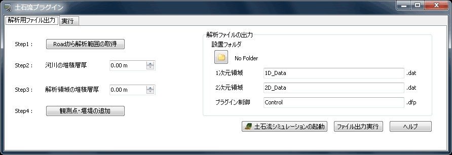
Export function
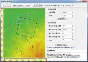
The region that you wish to analyze can be specified by simply clicking the said region within the UC-win/Road terrain data. The terrain data input process has been automated so that time and effort can be greatly saved.
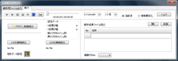
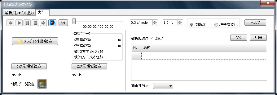
Visualization function
The result analyzed via Debris-Avalanche Simulator can be visualized using UC-win/Road. The flow of debris-avalanche and the effected region can be visually understood, making the system a great presentation tool.
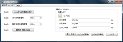
▲Exporting data
▲Visualizing data
▲Obtaining the analyzed region from UC-win/Road
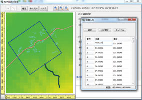
▲Adding observation points and enclosing bund
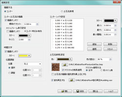
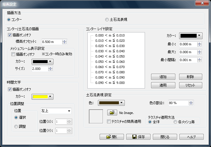
▲Drawing option
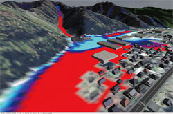

▲Visualizing the results of Debris-Avalanche analysis
(Left: Counter expression, Right: Approaching mudslide)

UC-1 Debris-Avalanche Simulation
Overview
-
This program adopts the "Debris-Avalanche Simulator (Kanako)" developed in the Graduate School of Agriculture, Kyoto University, as a solver, and has the ability to run a debris-avalanche analysis effectively in a series of process thanks to pre-processing and post-processing features built into the program by FORUM8.
Feature
-
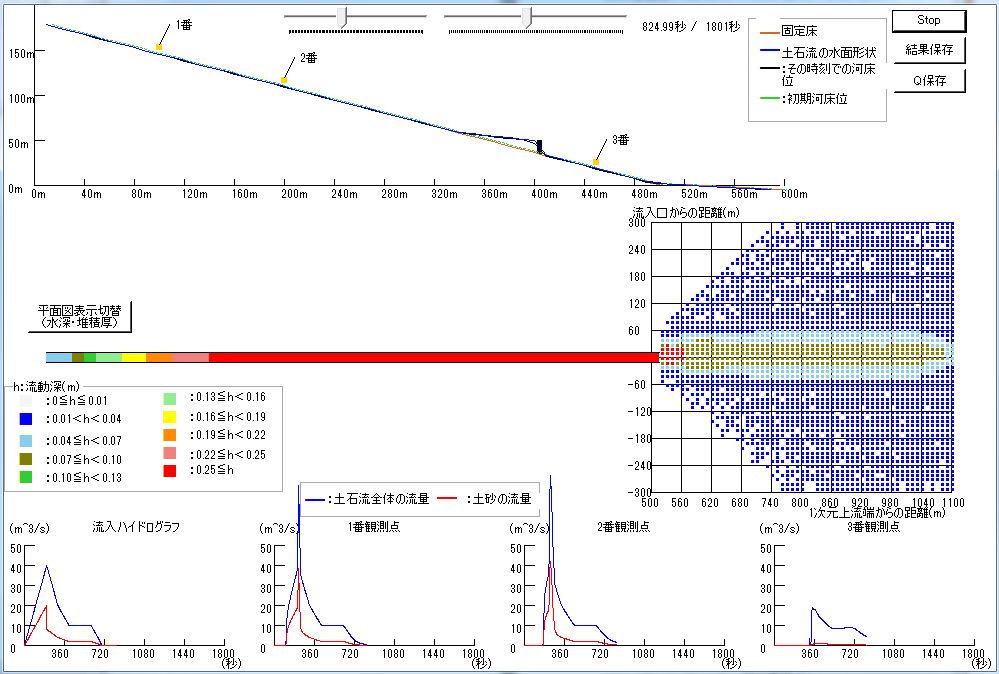
- Water surface/ river-bed form
- Flow depth
- Deposition thickness
- Hydrograph of observation point
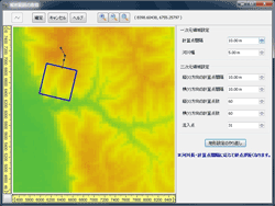
In order to take into account the effect of prediction on the damage that a debris-avalanche can do as well as the effect of physical barriers such as check dams have on the debris-avalanche, the calculation must be done on both the steep region (1 dimensional region) where the debris-avalanche originates and propagates and the low-angle alluvial fan (2 dimensional region) where the debris tend to overflow or pile up putting people and their houses within the area that risk. The "Debris-Avalanche Simulator (Kanako)", a solver that is used in this simulation, adopts the coupled model. How it works is that the steep region is calculated using the 1 dimensional model and the low-angle alluvial fan is calculated using the 2 dimensional model, and the result of each calculation interacts with one another at the entrance to the valley which is considered the boundary of the 2 region, allowing the system to integrate each calculation result in order to find the overall effect of the debris-avalanche prediction and measures.
The figure below is a window from the "Debris-Avalanche Simulator (Kanako)" showing the analysis result, which can also be displayed for visual confirmation through the UC-1 Debris-Avalanche Simulation.
▲Screen for 2D terrain via Kanako
(Water depth is displayed.)
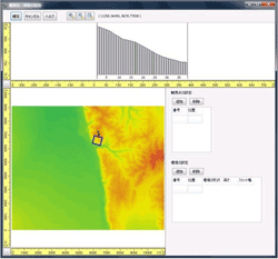
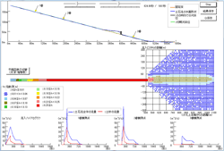
For analyzed results, the following items can be visually confirmed.
▲Main screen
▲One-dimensional domain
▲Two-dimensional domain
▲Hydrograph of inflow
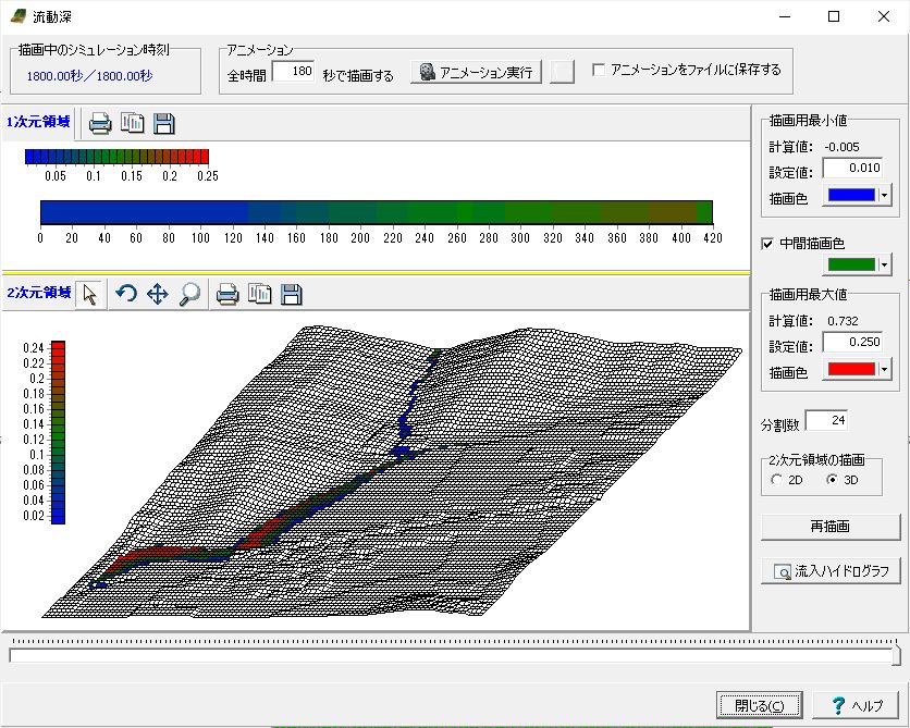
▲Analysis result of flow depth
Automatic Calculation of Hydrograph Using Rainfall Intensity and UC-win/Road Terrain Data
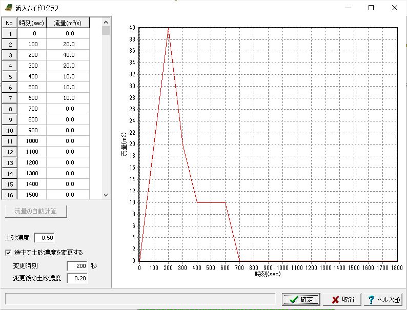
To calculate the time-series amount of debris flow with this product, it is necessary to input the flow rate coming in river or in path of debris flow as hydrograph. However, users have to calculate the amount of flow separately or prepare for data published by observatories before creating the hydrograph. In this version, the flow rate can be calculated by using the rainfall intensity and the terrain data in UC-win/Road and can be entered as a hydrograph. A general analysis method of flow analysis "Kinematic Wave method" is used for the calculation of the flow rate. The concept is shown in Figure 1. The basin is divided and replaced with simple models, then it calculates the amount of runoff in each section per unit hour. The outflow from the upstream is naturally calculated too. Enter the computed time-series amount of flow at the end of the basin as a hydrograph.
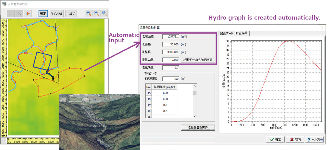
▲Automatic creation of a hydrograph
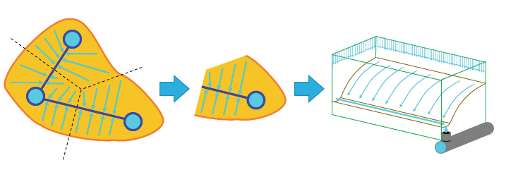
▲Concept of Kinematic Wave method
Import of LandXML File
Supports the import of LandXML files that are encouraged for BIM/CIM. This enables debris flow simulations by terrain data in LandXML format that is often used for reviews and designs.
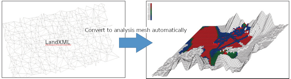
▲Utilization of LandXML import
Data Cooperation with Sediment Control Dam Design 3DCAD
Supports the data export for "Sediment Control Dam Design 3DCAD" containing each condition of dam set in the Debris Flow Simulation. This function makes the input with "Sediment Control Dam Design 3DCAD" simpler and the design process smoother. In addition, if conditions exported from the debris flow simulation are changed in the "Sediment Control Dam Design 3DCAD", the modified data can be imported in the debris flow simulation again to update the height of dam and other data.
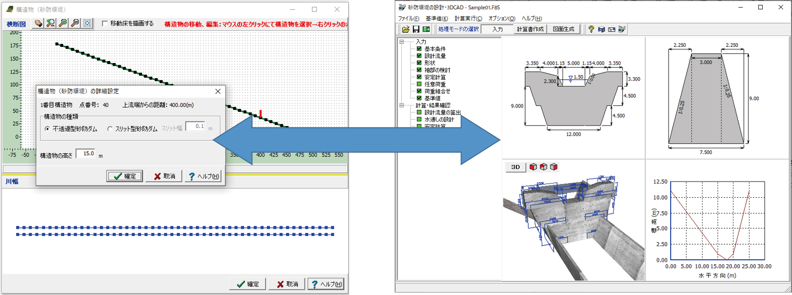
▲Cooperation between the UC-1 Debris-Avalanche Simulation and the Sediment Control Dam Design 3DCAD.
Applicable criteria and reference
-
- Takashi Wada, Yoshifumi Satofuka, Takahisa Mizuyama. Integration of 1- and 2- dimensional models for debris flow simulation. In Journal of the Japan Society of Erosion Control Engineering Vol.61, No.2, p.36-40, 2008.
- Kana Nakatani, Yoshifumi Satofuka, Takahisa Mizuyama. Development of "kanako Ver.1.10", a wide use one dimensional debris flow simulator equipped with GUI. In journal of the Japan Society of Erosion Control Engineering Vol.61, No.2, p.41-46, 2008.
- Kana Nakatani, Takashi Wada, Yoshifumi Satofuka, Takahisa Mizuyama. DEVELOPMENT OF AN USER FRIENDLY DEBRIS FLOW SIMULATOR EQUIPPED WITH GUI. In Proceedings of the 4th symposium on sediment disasters, p.149-154,2008.
- Yoshifumi Satofuka, Takahisa Mizuyama. Numerical simulation on a debris flow in a mountainous river with a Sabo dam. In journal of the Japan Society of Erosion Control Engineering Vol.58, No.1, p.14-19, 2005.
Price
Product Price
> Click here for the price of UC-win/Road
■Product Price
Product
Price
UC-win/Road Debris Flow Plugin Option Ver.3 USD3,360 ■Price of Floating License
Paying 40% of the product price allows anyone to use the product on any PC anywhere in the world.
Product
Price
UC-win/Road Debris Flow Plugin Option Ver.3 USD1,344
Price of Subscription Service Contract
Price of Subscription Service Contract
-
■Support information
-Software upgrade -Technical inquiry (Email, Tel)
-Download service -Maintenance and update notifications via email
* We are sequentially making a transition from the maintenance-support service to [Subscription Service] from April 1, 2016 in order to enhance support for diverse product usage and to reduce license management cost.
Product Subscription cost
of first yearSubscription cost
of subsequent years
(annual cost)Subscription
(UC-win/Road Debris Flow Plugin Option Ver.3)Free USD1,344 Subscription
(UC-win/Road Debris Flow Plugin Option Ver.3 Floating)USD1,881
Price of Rental License / Floating License
■Rental license : Short term licenses available at a low price
■Rental floating license : After web activation, anyone can use the products on any PC anywhere in the world.
■Rental access : You can increase the number of licenses you own and use these additional licenses for a specific period of time (1 month to 3 month) at your discretion. We will later send you an invoice based on your usage log. The advance application is 15% off of the regular rental license price. Please place an order from User information page.
*Rental / Floating Licenses were introduced on September 2007 to enhance user experience and convenience of our products.
*Duration of Rental / Floating Licenses cannot be changed after starting these services. Re-application is required to extend the rental and floating license duration.
Rental license / Rental floating license
-
■Rental License
Product 2 month 3 month 6 month UC-win/Road Debris Flow Plugin Option Ver.3 USD1,512 USD1,780 USD2,184 ■Rental Floating License
Product 2 month 3 month 6 month UC-win/Road Debris Flow Plugin Option Ver.3 USD2,520 USD2,990 USD3,696 Version Update History
Version Update History
-
■The version upgrade and revision upgrade (without charge) contents are listed as following.
UC-win/Road Debris Flow Plugin Option Ver.3 Version Release date Update contents 3.0.0 20/10/20 - Supports river basin setting for the automatic calculation of hydrograph in Debris Flow Simulation
- Expanded the number of grid points in the 2D area in the plugin from 200x200 to 300x300.
UC-1 Debris-Avalanche Simulation Ver.2 Version Release date Update contents 2.0.0 20/10/20 - Automatic calculation of hydrograph using rainfall intensity and UC-win/Road terrain data
- Import of LandXML file
- Data cooperation with Sediment Control Dam Design 3DCAD
- Batch setting of river width
- Setting of coordinate value of fixed floor and moving floor
- Expanded the number of grid points in the 2D area in the plugin from 200x200 to 300x300.
Product Operation Environment
Product Operation Environment
-
OS Windows 10 / 11 (64bit OS is recommended) CPU Intel® i5-3470,i7-3770, or greater
(Greater than CPU clock 3.2GHz, quad-core is recommended)Memory (including OS) 4GB or greater is recommended. (64bitOS+8GB or greater is recommended.) Disk capacity 1GB or more (4GB or more is recommended.)
* Disk capacity required for the installation of this plug-in separate from the UC-win/RoadVideo card NVIDIA® GeForce GTX560 or greater. Greater than 1GB and OpenGL3.1 for video memory.
(Greater than GeForce GTX670, Quadro 4000, and greater than 2GB and OpenGL4
for video memory are recommended.
>> Video CardDisplay (Image resolution) Greater than 1024 x 768 (greater than 1920 x 1080 is recommended) Input data extension DFP, DAT Note Plugin for UC-win/Road Order / Contact Us
Order / Contact Us
-
■ Inquiry
Contact us from Sales inquiry or email to ist@forum8.co.jp or forum8@forum8.co.jp
画面サンプル

▲LandXML地形データのインポート

▲トンネル交差部

▲杭基礎問題

▲トンネル問題

▲堤体内の浸透検討

▲集水井の検討

▲応力ベクトル図

▲変形図

▲変位図

▲境界条件

▲最大ひずみ応力

▲切断面コンタ図

▲ポテンシャル図

▲間隙水圧

▲流速ベクトル

▲ベクトル図

▲材料特性の入力ダイアログ (浸透流解析)

▲等値面

▲等値面

▲飽和度

▲z方向動水勾配

▲レポート出力(GeoFEAS)

▲レポート出力(VGFlow)
Q&A(製品評価や導入の際に役立つQ&Aです)
- 何ができるのか?
-
3次元汎用解析ツールとして、2次元モデルから3次元立体フレームモデルまで作成可能です。
また、板要素を使用したFEMモデルも作成可能で、部材は線形要素から非線形要素まで、荷重も静的荷重から動的荷重まで対応可能となります。
- どのような計算に活用できる?
-
橋梁の静的解析や動的解析、河川構造物の耐震計算や水道施設の耐震診断、建築構造物の計算に活用できます。
また、他社にない機能としまして弊社のUC-1設計シリーズの橋台・橋脚・基礎・震度と連携して、保耐法の計算データから動的解析が可能なデータを自動生成可能です。
- 報告書として成果に活用可能?
-
もちろん可能です。ただし対象を桁橋や直線橋などに限定していませんので、出せるものは計算書レベルの出力となります。
Excelへのカット&ペーストが可能ですので報告書のひな形へ貼り付けながら結果をとりまとめることが可能です。
- どのような基準に対応している?
-
橋梁設計で使用される道路橋示方書のH14年版、H24年版、H29年版に対応しています。
また、断面照査ではコンクリート標準示方書の限界状態設計法にも対応しており、構造物の照査まで可能です。
- どのグレードを購入すればよい?
-
線形解析、静的解析メインの方はLite版、フレーム解析で非線形解析、動的解析まで必要な方はadvanced版、非線形のFEM解析が必要な方はultimate版をご購入下さい。
- 入力について不明な場合は?
-
製品ヘルプもしくはHPに電子マニュアルに製品詳細と操作法を準備しております。その他、定期的に開催される有償セミナーでは静的解析モデル、動的解析モデル、FEMモデルの3つのモデル化の講習が受講でき講師と質疑応答も可能です。また有償となりますが、計算モデルを作成する解析支援サービスもあり年間100件を超える実績がございます。
解析支援サービス:https://www.forum8.co.jp/product/ucwin/ES/ESkaiseki.htm>> サポートページ Engineer's Studio® Q&A集


LOADING


