
Mitsui Consultants Co., Ltd.
Leader of Disaster Research Lab, MCC Lab Mr. Tsuguomi Harada
Product Used UC-win/Road Ver.15(Debris Flow Plugin Option)
Advanced real-time simulation software based on 3DVR technology that is widely used in urban and transportation planning, vehicle development, and information systems in general. The "Debris flow simulation function" visualizes the time series of the mudflow in 3DVR space after the debris flow analysis process.
Towards the Promotion of Effective Countermeasures Against Debris Flow Using DX Technology
Mitsui Consultants Co., Ltd. Leader of Disaster Research Lab, MCC Lab
Mr. Tsuguomi Harada
In 1997, he joined Mitsui Kyodo Construction Consultants Co., Ltd. and served as General Manager of the Erosion Control Department. In recent years, he has been working mainly in the field of road disaster prevention, including the advancement of road earthwork structure design, disaster prevention measures using DX (CIM/BIM) and AI, and maintenance of infrastructure. On the other hand, as part of his social contribution activities, he is involved in research and development of standards related to national land toughening as an expert member of the Japan Society of Civil Engineers, the Japan Road Association, and the Construction Consultants Association.(Visiting Professor at Ritsumeikan University / Researcher and Doctor at Kyoto University Graduate School. [Engineering/Agriculture], Professional Engineer [Construction Department])

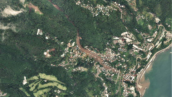
Photo 1: Aerial view of the area around the mudslide disaster in Izusan district, Atami City, July 2021 Copyright ©️ Map and Aerial Photograph Browsing Service GSI
Introduction
In recent years, there have been many reports of massive mudslides caused by unexpected torrential rains and other disasters and dealing with these disasters has become an issue. Especially in Japan, where about 70% of the land mass is mountainous, the topography is steep and the geology of the earth is fragile, resulting in risk of mudslides due to heavy rainfall being extremely high. There have been many reports of severe human and economic damage caused by mudslides nationwide, and there is a strong social need to prevent and mitigate such mudslide disasters. Under these circumstances, the mudslide that occurred in Atami City, Shizuoka Prefecture in July 2021 (Photo 1) was filmed by ordinary residents and posted on to social media, which increased public interest in mudslide damages.
Under these circumstances, the mudslide that occurred in Atami City, Shizuoka Prefecture in July 2021 (Photo 1) was filmed by ordinary residents and posted on to social media, which increased public interest in mudslide damages.
On the other hand, in response to the drastic changes in the socioeconomic situation, the infrastructure sector will also be able to utilize data and digital technologies as The Ministry of Land, Infrastructure, Transport and Tourism (MLIT) is committed to transforming the social infrastructure and public services, as well as the business itself, the organization, the processes, and the culture and working style of the construction industry and MLIT. Additionally, in order to realize safe, secure, and affluent lifestyles, there is a need to promote digital transformation (DX) in the infrastructure field, and more effective use of existing 3D topographical data (e.g., smooth project promotion using VR data) is expected in the future (Fig. 1, Fig. 2).
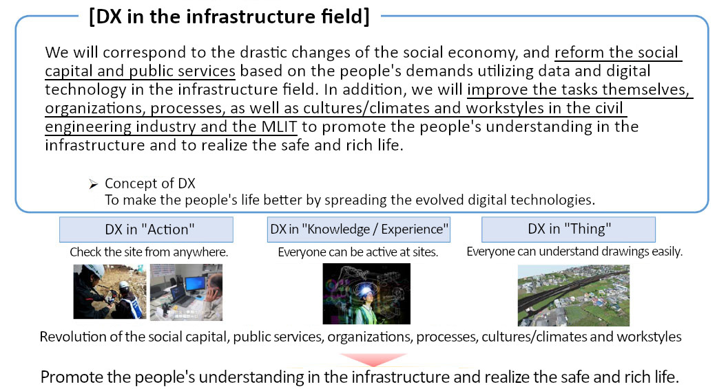
Figure 1: Objectives and overview of DX in the infrastructure sector (Created by editing “DX in the Ministry of Land, Infrastructure, Transport and Tourism: Promoting Digital Transformation” )
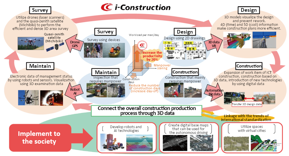
Figure 2: Coordination of 3D data in the entire construction process to promote i-Construction (Created by editing “DX: Digital Transformation in the Ministry of Land, Infrastructure, Transport and Tourism”)
Based on this background, this paper presents an overview of the "Mudflow Plug-in (UC-win/Road Ver.15)" and its utilization, which is one of the effective tools for further effective utilization (DX promotion) of digitized terrain models in future countermeasures against mudslides (e.g., Photo 2). An overview of the "Mudflow Plug-in (UC-win/Road Ver.15)" and its application will be presented.
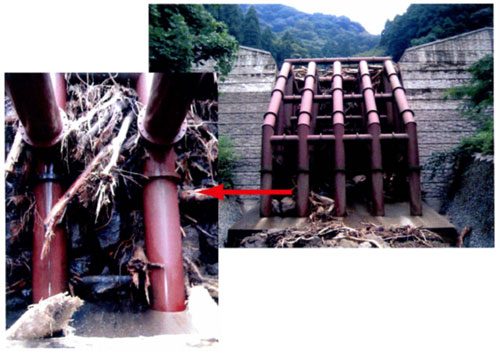
Photo 2: An example of a debris flow countermeasure project (erosion control weir) that captures debris flows to prevent mudslides downstream.
Overview of Debris-Avalanche Simulation Model (UC-win/Road Ver.15;Plug-in)
The " Debris-Avalanche Simulation Model", which is a plug-in for "UC-win/Road Ver.15" introduced here, has been developed using the existing research model (existing analysis model) shown in Table 1 as its calculation engine. As shown in Table 1, Debris-Avalanche Simulation Model can perform a series of calculations to predict the flow of debris avalanche, the inundation and sedimentation from debris avalanche, and the effectiveness of debris avalanche countermeasure projects such as erosion control weirs. Debris-Avalanche Simulation Model is designed to interoperate with the “UC-win/Road Ver.15” software to allow data to be imported and exported to and from each other. For example, terrain data from UC-win/Road can be imported into Debris-Avalanche Simulation Model to perform debris flow simulation, and analysis results can then be imported into UC-win/Road for visualization (Figure 3).
| Calculation Model | Overview |
| Prediction of the flow of debris avalanche (1 dimensional model) | A proposed computational model for predicting the temporal evolution of debris avalanche (including erosion, sedimentation and other fluvial changes) in mountain rivers2) |
| Prediction of inundation and sedimentation from debris avalanche (2 dimensional model) | A two-dimensional extended computational model for predicting damage to houses and other structures of concern in downstream areas caused by debris avalanche 3) |
| Effectiveness of debris avalanche countermeasure projects such as erosion control weirs | Calculation model for predicting the effectiveness (amount of sediments they can catch) of planned erosion control infrastructures of many types from permeable to impermeable erosion control weirs.2), 4) |
Table 1: Overview of Debris-Avalanche Simulation Model
(Calculation engine embedded in the model1))
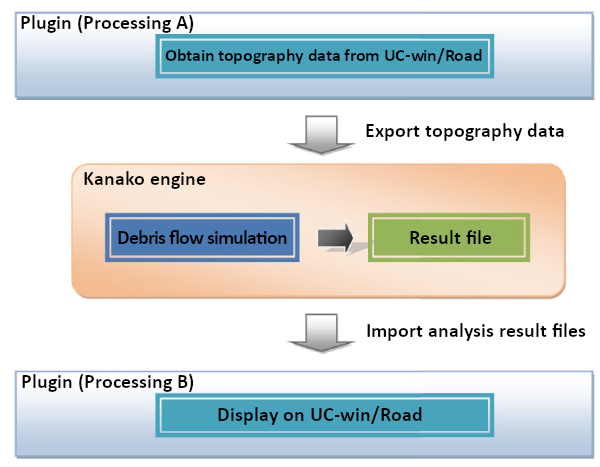
Figure 3: Relationship between "UC-win/Road (the main software)" and "Debris-Avalanche Simulation Model" (Model structure)
Reference
- Kana Nakatani, Takashi Wada, Yoshifumi Satomi and Takahisa Mizuyama: Development of a general-purpose debris flow simulator with GUI, Proceedings of the Symposium on Landslide Disaster, Vol.4, 2008
- Yoshifumi Satomi and Takahisa Mizuyama: Numerical Simulation of Debris Flow and Deposition in an Area with an Erosion Control Dam, Journal of the Japan Society for Erosion Control, Vol.58, No.1, p.14-19, 2005.
- Takashi Wada, Yoshifumi Satomi and Takahisa Mizuyama: Coupling of 1-D and 2-D Simulation Models of Mudflow, Journal of the Japan Society for Erosion Control, Vol.61, No.2, p.36-40, 2008.
- Yoshifumi Satomi and Takahisa Mizuyama: Numerical Analysis of Mudflow Control by Grid-type Erosion Control Dam, Journal of the Erosion Control Society of Japan, Vol.57, No.6, p.21-27, 2005.
One of the many great features that the system comprising of UC-win/Road Ver.15 and Debris-Avalanche Simulation Model has to offer is user-friendliness; the necessary conditions (e.g. topographical conditions and the location to install the planned erosion control weir) for the simulation of the debris flow can be input by simple mouse operations such as dragging (e.g. Fig. 4, Fig. 5 and Fig. 6). In addition, the system has a function to easily export the results of the debris avalanche simulation (flow) as a VR movie that can also be monitored over time (Fig. 7).
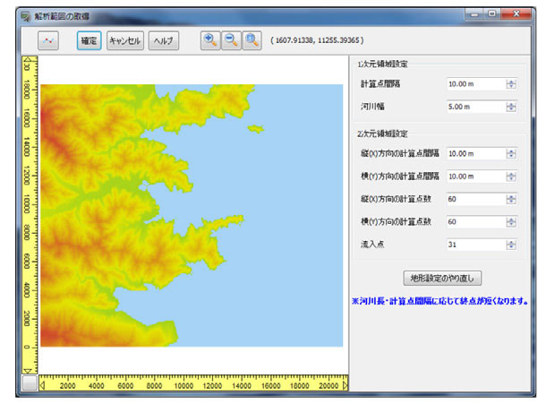
Figure 4: Settings of the debris flow analysis range
from the constructed
UC-win/Road terrain model
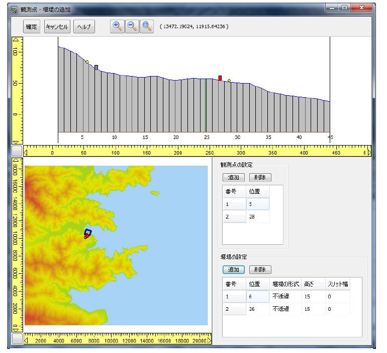
Figure 5: Settings of the location of erosion control weir
and observation
points (locations for calculating the
amount of debris flow) (Simple mouse
drag operation)
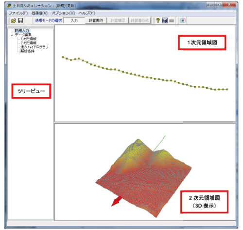
Figure 6: Input/confirmation screen
(easy-to-understand screen configuration)
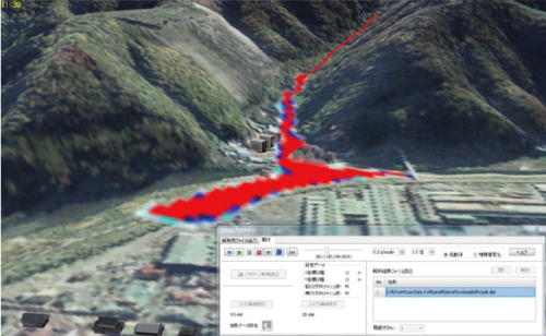
Figure 7: Visualization of debris flow simulation results
(Creating VR movies that take into account temporal changes)
Here, an example of the expected ROI that can be expected from using Debris-Avalanche Simulation (UC-win/Road Plug-in) for a debris flow countermeasure project (e.g. Photo 2) is outlined in Table 2.
| Effect | Overview |
| Visualization of potential risks and the result of risk assessment | Explaining the risk of potential damage from mudslide disasters to project proponents (managers) and project beneficiaries (local residents, etc.) in an easy-to-understand manner by visualizing the results of complex calculations. |
| Visualization of the impact that a project can make | The effectiveness of the proposed debris flow control infrastructures in the area (e.g. how well erosion control weirs can trap sediments) are also explained. |
| Landscape evaluation | Furthermore, the potential impact that the planned erosion control weirs can make on the surrounding landscape in terms of aesthetics as well as the construction progress can be explained intuitively by linking Debris-Avalanche Simulation Model with UC-win/Road |
Table 2: Expected ROI from implementing Debris-Avalanche Simulation Plug-in (UC-win/Road Ver.15) in mudflow control projects
As shown in Table 2, FORUM8’s system can be applied to "Visualization of the results of (mudflow damage) risk assessment", "Visualization of potential impacts that mudflow countermeasure projects can make", and “Landscape evaluation (the impact of erosion control weir construction project on aesthetics, etc.)", which are important for project promotion.
For reference, Figure 8 shows an example of visualization using "UC-win/Road" and "Debris-Avalanche Simulation Plug-in" (example of video material).
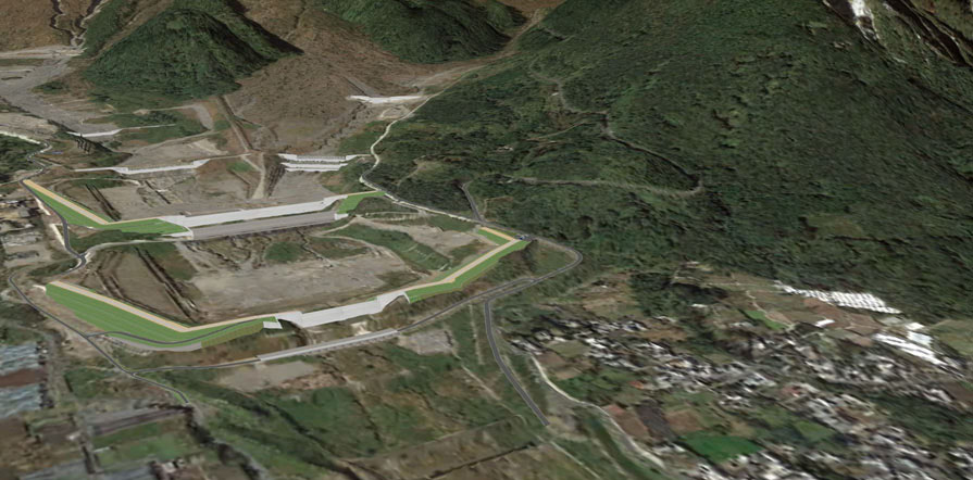
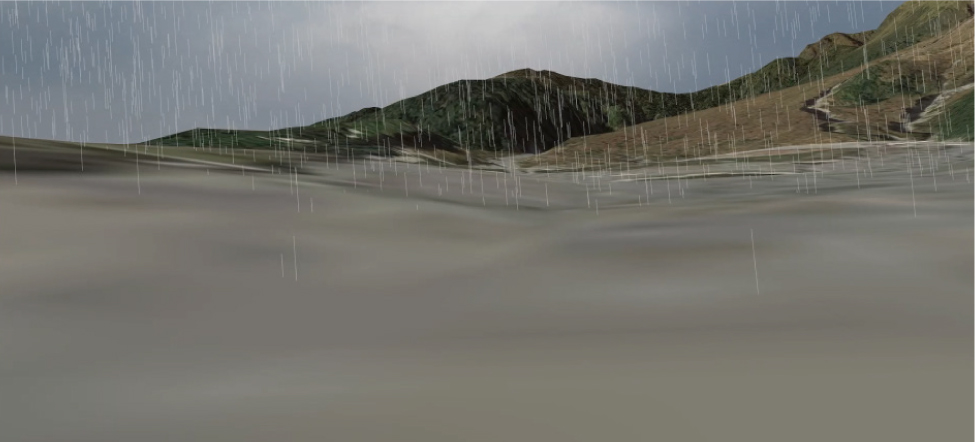
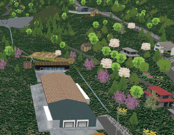
Figure 8: The layout of erosion control facility (Left) and the status of debris flow visualized in UC-win/Road (Right)
Figure 8 (top) shows the layout of erosion control facility and (bottom) shows the results of the prediction of debris flow at the viewpoint in the stream (debris flow point). The visualization of the VR by "UC-win/Road" enables us to understand these situations in detail. In addition, the use of a head-mounted display is expected to enhance the sense of realism (Photo 3).
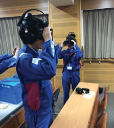
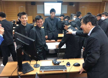
Photo 3: An example of a hands-on class using VR with a head mounted display etc. (broadcast by NHK)
Conclusion
This time, for further dissemination of DX, such as effective use of existing terrain models, we introduced the mudslide simulation function of UC-win/Road Ver.15 plug-in, its application example, and the effectiveness as one of the tools for creating visualization materials that are considered to be effective in promoting smooth countermeasures against mudslides. In the future, these efforts are expected to lead to technological innovation for the further accelerating digital era.
Under these circumstances, the mudslide that occurred in Atami City, Shizuoka Prefecture in July 2021 (Photo 1) was filmed by ordinary residents and posted on to social media, which increased public interest in mudslide damages.
On the other hand, as a future prospect of this plug-in, it is expected to be extended to the prediction of the flow of driftwood (e.g., Image 4) generated by mudslides, which have become a problem in recent years, as well as the prediction of the effects of countermeasures.
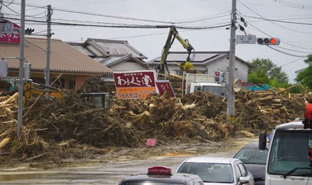
Photo 4: Damage caused by driftwood in the torrential rain disaster in northern Kyushu
Users Report
Users Report/ Vol. 117 (Published April 2017)
Mitsui Consultants Co., Ltd.
The 14th 3D VR Simulation
Contest on Cloud Idea Award
"Using VR to Communicate to the Locals Over Debris Avalanche Countermeasure"
The 15th 3D VR Simulation Contest on Cloud Essense Award
"Facility planning of a ski field considering user's viewpoint"
(Up&Coming '22 New Year Issue)
|
||||

 Up&Coming |
