
International Newsletter vol.44 2011/3
3.31.2011 FORUM8 Co., Ltd. http://www.forum8.com/
|
| Special support for the 2011 off the Pacific coast of Tohoku Earthquake |
We would like to express our sincere condolences for all those who have
been affected by the devastating earthquake.
At this stage, FORUM8 has decided to provide the special support to aid
the victims of the earthquake, which occurred off the Pacific coast of
Tohoku on March 11, and to support the recovery efforts in the affected
regions, we have come up with the following:
| Special Support 1: FPB Point Donation Service |
We have started a FPB point donation service for the organizations that
supply the supportive activities. The donated points are used for those
who have been afflicted as the charity and emergency aid through each organization.
If you are interested in a donation service, please contact our sales staff.
|
| Special Support 2: Free Rental License Service |
We have started a six month free rental license for the users in the affected
regions. The owned licenses are reissued as a six month rental license
without charge.
The products can be used via an internet connection for downloading of product files and to send and receive the mails.
For details, please contact our sales staff.
Support Area: 1295 users (as of March 17th, 2011)
Prefecture of Aomori, Akita, Iwate, Miyagi, Yamagata, Fukushima, and some parts of Ibaragi
|
|
|
| New Product Information - UC-win/Road Ver.5.2 Italian Version |
| Release schedule : April 2011 |
Simulation |
|
| Features of
Italian version |
FORUM8 will release UC-win/Road 5.2 Italian version. It has the same
function as other UC-win/Road and the menu/helps are written in Italian (Figure
1 and 2). In addition, it will support for the import of terrain data (Figure
3).
 |
|
 |
|
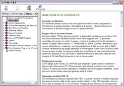 |
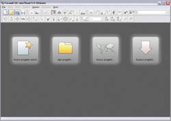
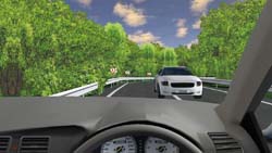
 Figure1 Figure1
Main screen of Italian version |
|
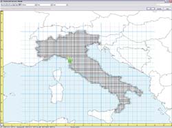
Figure 2
Supports for the geographical data in Italy |
|
Figure 3
Italian version
help |
|
| Reason behind
this release |
One reason behind this release is the research project of one of World
16 members, Assistant Professor Paolo Fiamma, Pisa University in Italy
using UC-win/Road. This research was introduced as "The parking in
the historical city in Italy" in FORUM8 Design Festival 2010 last
year. In the project of developing historical area in Pisa, 3D models are
created with UC-win/Road and the construction project of underground parking
is focused to simulate the pedestrian's flow and its effect on traffic.
We will hold the World 16 Summer
Workshop in July 2011 in Pisa University, where Assistant Professor Paolo Fiamma
is currently working.
The VR simulation of UC-win/Road is expected to be
expanded in Italy through his research project and the release of UC-win/Road
Italian version. We will integrate the pedestrian traffic simulation which has
been related with his project to UC-win/Road in the future version. |
|
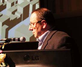
Assistant Professor Paolo Fiamma
(Pisa University,
Italy) |
|
|
| New Product Information - UC-win/Road Ver.5.2 Replay Option |
UC-win/Road Ver.5.2 Replay
Option  |
| Registration and replay of VR simulation |
| Release schedule : March 2011 |
Simulation |
|
This plugin allows the registration and replay of the vehicle and model
movement. When you perform manual driving while running the driving simulation,
you are able to check various accidents such as contact accident, accident with
guardrail from outside of vehicle (Figure1). You are also able to find out about
details of the traffic simulation in the intersection. This plugin is very
useful for these cases.
 |
 |
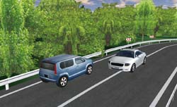 |
| Figure1 : The accident while
driving simulation can be checked from outside of
vehicle |
|
| Main function
& Good point |
The vehicles and pedestrians that are moving every second can be registered
in a couple dozens times a second and replayed in real-time (the number depends
on the machine capacity).
As for the vehicle, the vehicle movement between
different grade level of road surface and the accident condition can be
correctly represented as real by registering the detailed behavior (roll /
pitch/ yaw) such as Figure2.
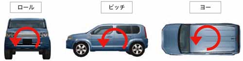 |
| Figure 2 : Vehicle's
behavior |
The behaviors to be registered
are shown in Table1. The traffic signals and contexts can be registered as well
as the vehicles and pedestrians.
| Vehicle |
Coordinate, roll, pitch, yaw, turn signal, brake
lamp |
| Pedestrians |
Coordinate, behavior, roll, pitch, yaw |
| Traffic signal |
Lighting status |
| Context |
Context while performing
scenarios |
Table1 : The behaviors to be
replayed
|
|
| New Product Information - UC-win/Road Education Version |
| Price: 38,000Yen(+tax) Scheduled release date: March 2011 |
Simulation |
|
| Standard
version without functional limitations |
FORUM8 is pleased to release UC-win/Road 5 Education Version.
This
product is intended for educational use. Pupils or students under 18 years of
age from elementary, junior, or high school students will be able to create
Virtual Reality environments at a special price. There are no functional
limitations to this newly released version. We will provide it as regular
UC-win/Road license.
 |
Education Version is intended for the creation of
3D
Virtual Reality environment by
UC-win/Road |
|
| Link with GIS
system by UC-win/Road SaaS capability |
| The Education version will not have linkages to GIS Web database which has
been made available. In future, FORUM8 is going to develop the link with the GIS
system using UC-win/Road SaaS capabilities. |
|
| New Product Information - UC-win/Road Point Cloud Data Modeling |
Available on UC-win/Road Advanced: To be released
March 2011
|
Simulation |
|
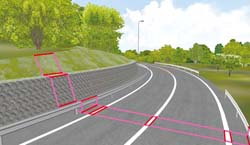
Point Cloud Data modeling is the plug-in option to utilize the information
of tens of thousands of point cloud data collected by 3D laser scanner in
UC-win/Road. It is available for a wide range of applications including modeling
structures/ road development and measurement and survey of terrain and buildings
data.
We will now introduce the process and user interface of road creation
using this plug-in option.
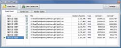 |
| Figure 1 Main control
window |
|
To create roads in UC-win/Road, road alignment and road section data are
necessary. Automated road creation with point cloud data allows highly precise
data modeling and reduction of time and cost.
There is a method of
measuring point cloud data, suitable for the work is called MMS or Mobile
Mapping System (referred as MMS below). This program extracts sequence of points
from MMS Point Cloud Data from the center line and generates a road alignment
and creates road easily by extracting and editing cross section of the road at
an arbitrary point.
Algorithm we have chosen to extract sequence of points on
centerline is "normal lines search", aligning MMS Point Cloud Data on scanned
plane and searching the next point by pointing according to an arbitrary point
on the plane and its normal line.
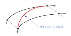
However, in some cases you cannot
acquire the best sequence of points on center line. For example, this will be
the case where the starting position is on the center line, however it is
gradually deviating to the road shoulder. We have implemented point line
revision function (Figure 2.3) to cope with this. t is the function to calculate
sequence of points on center line by defining arbitrary two points, searching
normal lines and arrange the provided 2 lines of point. With this method, you
can acquire sequence of points on centerline as you like and can generate road
with minimum input.
 |
|
 |
| Figure 2 Point line revision function |
|
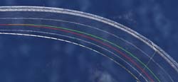
Figure 3 Effect by point line revision function
(Red line: before
application, Green line: after
application) |
|
|
| New Product Information - UC-win/Road Physical Model and VR System |
| UC-win/Road Physical Model and VR
System |
| Simulation / presentation system in combination with physical model and
VR |
| Proposed system: To be released in
2011 |
Simulation |
|
"UC-win/Road Physical Model and VR System" was developed based on the idea
and cooperation of Associate Professor Tomohiro Fukuda of Osaka University, a
member of W16. Thanks to the technology of providing a combined operation
environment of physical model and VR system, it is a new type
simulation/presentation tool combing the features of both environments.
The
system allows you to present information effectively and efficiently to the
people concerned with different background and varying knowledge
levels.
|
| Tool for
examination with advantages of both physical and VR
model |
VR is highly flexible and expressive, and allows various considerations such
as reproduction of traffic flow or changed weather conditions, which is
impossible through a physical model. On the other hand, a physical model is more
intuitive in grasping the big picture of the plan, such as size and project
scope. Physical model allows various people to examine from the arbitrary
viewpoints at the same time, understanding the whole city model simultaneously
and touching the model directly.
By combining both the physical model and
VR, UC-win/Road Physical Model and VR System enables considering planning with
more intuitive and easier operation, compared from VR itself. In addition, by
utilizing our "3D Physical Modeling Service" customers can produce physical
model from VR data of UC-win/Road in a short time through the use of a 3D
printer. It allows the development of a physical model and VR system effectively
|
|
| New Product Information - UC-win/Road Noise Simulation Option |
| UC-win/Road Noise Simulation
Option |
| 3D Real-time VR Software |
| To be released February, 2011 |
Simulation |
|
| Overview of
UC-win/Road Noise Simulation Option |
This option is for the simulation of noise production in general by locating
the sound source and for receiving sound on UC-win/Road. Sound pressure level
calculation can be performed by considering the effect of ground surface and
buildings.
|
Noise Simulation option consists of Pre-processor (for data input), main
processor (for simulation) and Post-processor (for presenting result).
Pre-processor
Considering the reduction of
the operation workload such as model placement, complicated noise simulation has
been enabled through few operation steps and the configuration of simulation
specifications. As for the placement of the sound source, configuration is
completed only by selecting arbitrary model, toggling sound on or off and
selecting characteristics of the sound source. As for the placement of sound
receiving point, multiple points can be placed along an arbitrary road at once,
for example, as well as placing the point one by one. In addition, it has a
convenient function, which allows searching sound sources and receiving points
in wide area.
Main
processor
The product provides you with abundant analysis option
varying from general setting to advanced configuration.
It allows you to
obtain precise analysis results according to wide variety of purposes.
In
addition, the main analysis content in this main processor is as
follows.
- To determine the number and order of diffraction, reflection, penetration
and attenuation of each radiation path
- Fading of sound pressure level according to the distances between the sound
source position and the sound receiving point
- Allowance of frequency weighting characteristics.
*A characteristic is
the coefficient for correcting data collected by sound pickup device for human
beings to hear.
- To combine the frequency of sound pressure level for each sound receiving
point
- To combine the sound pressure level when the sound of multiple paths reach
the receiving point
- To calculate equivalent continuous A-weighted sound pressure level (1998 the
Environment Agency Notification No. 64)
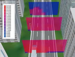
Post-processor
Rich display options help you to capture the simulation results from various
viewpoints. In addition to contours and contour lines commonly used for
presenting the simulation results, the option also has a unique ability:
visualizing sound pressure level by grid or sphere shape.(Figure3~4)
 |
|
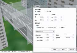 |
| Figure1 Locating sound source |
|
Figure2 Placing points at once |
 |
|
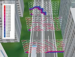 |
| Figure3 Visualization by contours |
|
Figure4 Visualization by contour lines |
|
|
| New Product Information - UC-win/Road SDK Ver.5.1 |
| Price: 300,000 Yen (+tax ) To be released March 2011 |
Simulation |
|
We are pleased to introduce new features of UC-win/Road SDK for UC-win/Road
Ver.5 and new features of forthcoming UC-win/Road SDK for UC-win/Road
Ver.5.1.
|
| Customization
of scenario (Ver.5.0) |
Users can now customize scenarios with Ver.5.0. You can set the environment
for the simulation with UC-win/Road scenario. Set the action under certain
circumstances through the combination of conditions and events. You can activate
the event according to the conditions, such as driving situations, other
vehicles situations, keyboard operations and driving operations. You can also
replay, generation of other vehicles, generation of pedestrians, changed
environment (weather, traffic, time, etc.), signal controls and media (text,
sound, video, images).
Customization of events in scenarios can now be
carried out through the use of the SDK. You can add custom settings on event
setting window and save the settings by using API and execute the customized
event by callback.
You can also acquire information on vehicles and other
moving object models by callback in real-time, which are generated by
UC-win/Road callbacks. By using this mechanism, you can enhance scenario
functions and control external applications or devices, depending on the driving
situation inside UC-win/Road.
|
| Acquiring
road shape information (Ver.5.0) |
UC-win/Road calculates the final road alignment from user-defined horizontal
alignment, vertical line and cross section of the road. With previous versions,
users can edit information of defined road alignment and cross-section by
acquiring them by SDK, however acquiring finalized information of the shape was
not possible.
With the latest released version, you can acquire this kind of
information. You can acquire quad information and the position, normal vector
and texture information, which constitutes road.
This function is very
convenient for exporting road shape generated by UC-win/Road to external tools,
including 3D models or analysis program. For example, UC-win/Road Noise
Simulation plug-in uses geometric information acquired by this function.
 |
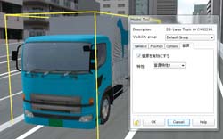
| Figure1 Quad information of
road |
|
|
| Conferences, training and seminars |
| Upcoming Events |
|
Seminars in Shanghai,
Beijing and Seoul will be held on the following
schedule.
Venue:
Shanghai - Shanghai
Seminar room (FORUM8 Technology Development(Shanghai) Co.,
Ltd)
Seoul-FORUM 8 Korean
Office
For more information and applications, please email us
at
mailto:forum8@forum8.co.jp
Gross circulation: 5520
To
subscribe this page, go to http://www.forum8.co.jp/english/p-mail-e.htm
If
you would like to unsubscribe from our newsletters, please include
"Unsubscribe"
in the subject title of your email and send it back to
us.
Thank you for your continued support.
FORUM8 Co., Ltd.
mailto:forum8@forum8.co.jp
Nakameguro GT Tower 15F
2-1-1 Kamimeguro Meguro-ku Tokyo 153-0051 JAPAN
TEL +81-3-5773-1888
FAX
+81-3-5720-5688
http://www.forum8.com/
|