 |
|
1. UC-win/ Road Ver.6
2. Forum8 won "International tunnel award" with Virtual Reality
Tunnel Operator System
3. Overseas Training and Seminars |
| UC-win/Road is the real-time VR software which allows the creation of 3D virtual
reality with simple operation. In Ver.6, the following functions are added and
improved. |
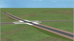
| Movement of
walking crowd |
In this new version, the function that creates a wide flight path (path way) in
3D space and allows the simulation of a walking crowd on the flight path is
added (Figure 1). In the previous version, the pedestrians walk on the
predefined line on a flight path. The reality is improved and the time required
for arranging many pedestrians is largely reduced in the new
version.
This function allows the simulation of behavior similar to the
human behavior by arranging many pedestrians at a time. In addition, the
pedestrians can avoid walking into each other. The network where the path ways
are connected to each other can be structured, and the pedestrians in the
network walk by choosing their own pathway.
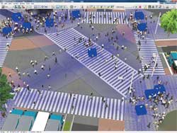 |
| Figure 1 Simulation of a walking crowd |
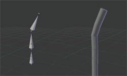
(1)What is path way?
The path way is a wide flight path for pedestrians to travel along. It consists
of beginning nodes and end nodes (Squares in blue shown in Figure 2)
and turning points between them (Circles in yellow shown in Figure 2).
Inclination can be given to the path way.
(2)Method of setting a path way
Unlike the existing flight path, a pathway can be created directly in 3D space
in the main window so you can see the position of the path easily and adjust the
height interactively.
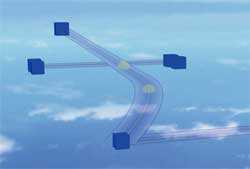 |
| Figure 2 Path way |
(3)Method of arranging pedestrians
There are two methods for arranging pedestrians, one method which generates
them set beforehand at random position soon after starting simulation and
another method which generates at constant intervals from the specified
node. In addition, an MD3/FBX model which is the model used for representing
a crowd is selected randomly from saved models..
(4)Walking algorithm
A pedestrian walks in such a way so that he/she won't walk into another
pedestrian (Figure 3). The parameters including field of view, view angle,
position coordinate, velocity vector of the pedestrian are considered, and
pedestrians who are in the field of view of the pedestrian per time step are
recognized. When other pedestrians are recognized by the pedestrian,
he/she changes his/her walking direction if necessary. In addition, an element
that makes the pedestrian follow another pedestrian if the former recognizes
that the latter is walking in the same direction has been added. Therefore, the
flow of people as a crowd becomes smooth.
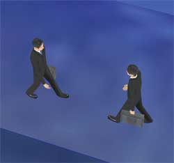 |
Figure 3 Avoidance
behavior of
pedestrian |
(5)Future development
As part of a future development, pedestrians will be integrated with traffic,
and a function that makes pedestrians wait in front of a crosswalk until traffic
light changes, find route to destination, and avoid obstacles like buildings
will be implemented.
|
UC-win/Road has started supporting 3D model in FBX since Ver.5. In this version,
static models (without animation information) in FBX format can be imported. In
Ver.6, animation information from can be also be imported from FBX files.
(1)FBX
animation
The FBX animation supported in this new version is called "Bone animation"
(Figure 4). Bone (framework) is the one which takes charge of a motion space of
3D model, and each joint plays the role of "joint". Therefore the more the
number of bones the model has, the bigger its motion space becomes and hence the
complicated and natural motion can be visualized.
All animation
calculation is performed by the shader, and the animation of many people can be
played with high FPS. In addition, it has the LOD (Level of detail) function
which maintains the performance by reducing the display accuracy of models shown
in small size similarly to MD3 character model.
 |
|
 |
| Figure 4 Example of animation using bone (Created
by using Blender) |
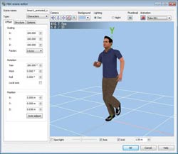
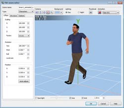
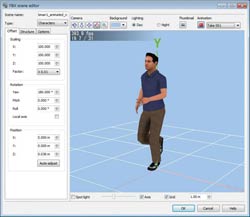
(2)Saving characters
The FBX models can be saved as characters in UC-win/Road since it started
supporting FBX animation. Saving can done in the "Save character model" window
which is an enhanced version of the existing "MD3 character list editor" window.
On this window, you can edit/delete characters, add them to mobile object, or
download them from RoadDB. "FBX scene editor" window in which you can
set execution speed of animation and its scale can be opened by clicking "Edit".
(Figure 5)
 |
 |
 |
|
 |
|
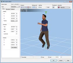 |
| Figure 5 FBX screen editor window |
(3)Scenario function also uses FBX models
FBX model can be used in a scenario. Saved FBX character model can be selected
on "Event editor" window which can be opened by clicking "Edit" on "Scenario
editor" window, or "Target model editor" window.
(4)Future
development schedule
Currently, you need to set movement of FBX animation in another application, but
we plan to make enhancements in UC-win/Road so that it can set movements of FBX
application. Furthermore, a function which connects meshes in which animation is
not set to an arbitrary bone is scheduled to be developed.
When the
function of connecting meshes to bone is implemented, animation can be set
easily by making the various actions a kind of library of bones.
(5)Future updated contents
For the future
revision, the integration with traffic is conducted; waiting in front of a
crosswalk until traffic lights' changing, route search to destination, building
etc.
|
The information such as object (building, tree), texture, crosswalk etc. can be
displayed as a list in tree format. Tree can be displayed next to the main
window. When you select an object in the tree, the object will be displayed on
the main window. You can also edit/delete an object name or use advanced search
to narrow your search to specific object names.
In addition, the
following verification functions are available in this plug-in, and you can use
these functions to confirm the consistency of the data that has been
created.
- Verify the total number of pixels in a texture: The texture having more than
or less than the number of pixels you have set is searched.
- Check for unconnected road connection point: This function searches for any
point on a road, which is already connected to another road such as a ramp,
that is not connected.
- Verification on buried model: Model buried in terrain or road is searched.
(Figure 6)
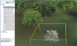 |
| Figure 6 The result of verification on buried model is displayed |
|
IFC(Industry Foundation Classes) data model is an international standard
developed by IAI for the purpose of promoting interoperability in the
construction industry. (Currently, the specification of this model is developed
and maintained by building SMART International.)
With this plug-in, the
terrain data in the file described in IFC format can be imported into
UC-win/Road as a terrain patch. Also, the 3D model such as the terrain or
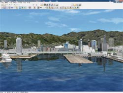
building in UC-win/Road can be exported in IFC format. Figure 7 shows a screen
you get when you import IFC file, which is exported from UC-Road, to
commercially available software. The left screen is UC-win/Road's screen and the
right screen is commercially available software's screen.
 |
|
 |
| Figure 7 UC-win/Road's screen and a screen showing the result of exporting
IFC file |
|
12d Model is an integration solution of terrain modeling, survey and civil
design, developed by 12d Solutions in Australia. It's used for a wide range of
project such as road project; designing layout of a construction site, building
lot for sale; and survey on environmental influence.
With this plug-in, by using "12d Ascii File" format which was
prescribed by 12d Solutions, the data collaboration between UC-win/Road
and 12d Model becomes reality. Data that can be exchanged is shown in table
1..
Table 1 Bidirectional linkage with 12Model
| UC-win/Road ⇒ 12d
Model |
| UC-win/Road |
12d Model |
| Mesh terrain |
Tins |
| Terrain patch |
Tins |
| Road alignment |
String Alignment |
|
| 12d Model ⇒
UC-win/Road |
| 12d Model |
UC-win/Road |
| Tins |
Terrain patch |
| String Alignment |
Road alignment |
| String Super Alignment |
Road alignment |
| String 4d for road sections |
Road
alignment |
|
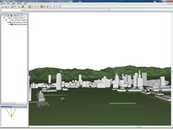
When importing 12d Ascii File into UC-win/Road, you select the terrain (Tin
data) and the road alignments you want to import and the convent them with the
template of road cross section. Template is the data, which has a mapping
information of cross-sectional attributes, used for importing the section data
of 12d Model into UC-win/Road. When it's imported properly, you will see a
result that looks like figure 8.
Moreover, when exporting from
UC-win/Road, you select objects (terrain, terrain patch, road alignments) and
specify the file name.
 |
| Figure 8 Import result of 12d Ascii
File |
|
| Linkage with
Tsunami analysis software |
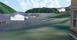
xpswmm plug-in is the one for visualizing the result of analysis performed by
flood analysis software xpswmm in UC-win/Road.
In this revision, result of
tsunami analysis can be visualized with a much higher degree of realism.
(1)Improvement of visualization
You can now choose to draw considering the reflection on water surface and
refraction, and use the following functions that have been implemented
additionally.
- Completion of mesh and smooth drawing of water's edge (Figure 9)
- Visualization of ripples on water surface (Figure10)
- Visualization of spray
 |
|
 |
| Figure 9 Smooth drawing of water's edge |
|
Figure 10 Visualization of ripples |
Detailed ripples on the water as well as reflections of the sky, sun and
moon, can be displayed, with a high degree of realism.
The amount of light reflected and refracted on water surface is calculated using
Fresnel formula. Therefore, if the angle of visual line relative to the water
surface is shallow, the amount of reflection (reflection of sky etc.) is large
as you can see on the left image of figure 11; conversely, if the angle of
visual line relative to the water surface is deep, the amount of refraction is
large, making the color of water dark.
 |
|
 |
Figure 11 Amount of reflection is large when visual line is shallow.(Left)
Amount of refraction is large when visual line is deep.(Right) |
(2)Visualization of level of damage done on buildings by tsunami
In this revision, a function that visualizes the level of damage done on
buildings by calculating the drag acting on buildings due to tsunami is
implemented.
Concretely, the level of damage on building is calculated
from the parameter of sunction power of energy set for each drag of tsunami and
building, and displayed in different colors indicating different levels as shown
in table 2. It's common to think that the level of damage done by tsunami
depends on the water height. But because this new function uses the water force
calculated by water depth, flow speed, and shape of building obtained by data of
xpswmm; and the drag that can be found by the water force; more accurate
analysis can be done.
Moreover, the development of a function that
exports a hazard map in which a flat distribution of different levels of damage
is displayed by color contour is also being considered.
Table 2 Example of contour color based on the level of damage on building
| Minimum(kJ) |
Maximum(kJ) |
Color |
Sample color |
Level of energy and breaking |
Height of wave(m) |
| 0.00 |
0.50 |
Blue |
|
No Swimming |
0.00-0.25m |
| 0.50 |
1.25 |
Green |
|
Person fall down. |
0.25-0.50m |
| 1.25 |
2.50 |
Yellow |
|
|
0.50-0.70m |
| 2.50 |
5.00 |
Orange |
|
Wooden house is partly collapsed. |
0.70-1.00m |
| 5.00 |
10.00 |
Dark orange |
|
|
1.00-1.50m |
| 10.00 |
20.00 |
Red |
|
Building likely to be destroyed completely. |
1.50-2.00m |
| 20.00 |
30.00 |
Dark red |
|
|
2.00-2.50m |
| 30.00 |
100.00 |
Purple |
|
|
2.50-5.00m |
| 100.00 |
- |
Black |
|
|
5.00m- |
|
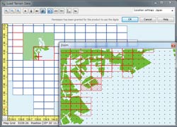
| 5m mesh can now be imported |
UC-win/Road can now import 5m mesh (elevation) data of digital map issued by
Geospatial Information Authority of Japan. It's possible to import 5m mesh data
into UC-win/Road as a terrain patch. There are 2 methods of importing, as
described below.
(1)By selecting the file
Lem file of 5m mesh is selected directly by going to "File"-"Load Terrain
Patch"-"Lem file". After selecting the Lem file, the terrain patch data can be
created using the elevation data of in the Lem file.
(2)Selecting mesh
Click the "5m" speed button on "Load Terrain Data" window in which the location
setting is Japan, and then select the Lem file. In case Lem is included when
selecting 50m mesh, 5m mesh screen is displayed separately. (Figure
12)
Selecting the surrounding area with a mouse on this screen and generating
the terrain generates terrain patch in 5m mesh on a terrain. (Figure13)
 |
|
 |
|
 |
| Figure 12 Lem selection screen |
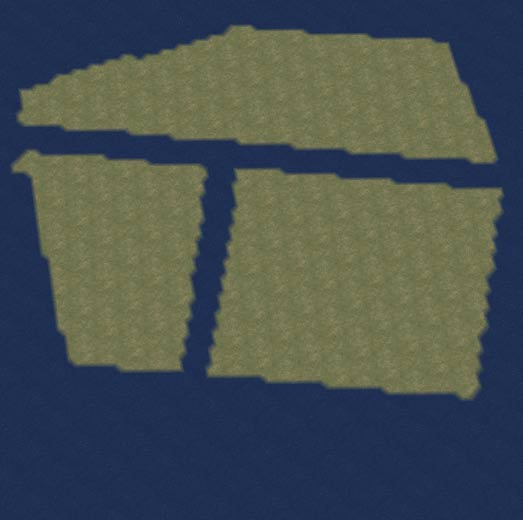
|
Figure 13 Comparison of 50m mesh(Left) and 5m
mesh(Right) |
|
| Parking for loading parking lot model |
It's a plug-in that imports parking lot drawing data created by FORUM8's CAD
system, "UC-1 Parking Drawing System", which designs parking lot based on
parking regulation.
The outer line of the parking lot, boundary line for
each parking space, and road marking (such as an arrow indicating the driving
direction) can be drawn accurately based on the CAD drawing. (Figure
14)
Since the imported drawing data, like buildings and cars, is
treated as a model, you can place it in an arbitrary position or rotate it.
 |
| Figure 14 Example of parking model
display |
|
| Improvement in smoke visualization |
Smoke inside and outside a tunnel can be visualized with a higher degree with
realism.
|
In the conventional version, scenery can be confirmed by setting a fixed camera
in VR space, and adding a camera view window. This feature has been enhanced in
the new version to allow placement of interactive camera. For example, a camera
can be set so that it follows a running vehicle from an arbitrary angle.
|
| New weather
visualization |
In this revision, the following 2 points features were added as an improvement
in visualization when it's raining.
(1)Water splashing behind types of the car ahead
UC-win/Road can now visualize water splashing behind tires of the car ahead
during driving simulation as seen in Figure 15. To visualize this, check
"Water splashing when it's raining" in the Visual options window.
 |
| Figure 15 Water splashing |
(2)Different settings for windshield wipers
You can now choose the speed of windshield wipers by selecting the parameter in
table 3 on the Visual Options window. Also, windscreen wipers alone can now be
displayed without having to use "windshield rainwater" or "weather function".
(Figure 16)
| OFF |
Non display |
| LO |
Low speed |
| HI |
High speed |
| INT |
Wipes intermittently |
| Custom |
Use the speed and interval set in the wiper setting
screen |
|
|
 |
| Table 3 Setting of wiper speed |
|
Figure 16 Visualization of windshield wipers |
|
| Vibrating game controller |
At the time of driving simulation using steering wheel game controller and
gamepad, vibration transferred from asphalt and gravel road and vibration
transferred when the vehicle runs over a rut etc. can be felt on the game
controller. This allows to recreate the real driving sensation.
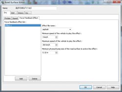
(1)Force Feedback function
In the Road Surface Editor window shown in Figure 17, you can assign vibration
data file to each road surface including "Dry", "Wet", "Snowy" and "Icy", and
set vibration effect.
By assigning a road surface a texture, vibration
will transfer to the game controller when you drive on the road surface.
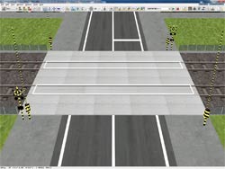
(2)Bump function
By setting road bump on an arbitrary position on a specified road, you can make
the game controller vibrate when the vehicle runs over the bump.
When you set
a bump on a rail track as seen in Figure 18, the game controller vibrates when
the vehicle goes over the rail track. Furthermore, if you set a bump on a rut of
a road or between roadway and walkway, realism in terms of vibration will
increase.
 |
|
 |
| Figure 17 Setting screen of road surface |
|
Figure 18 Setting of bump to rail
crossing |
|
(1)Slipping sound
Squealing sound that the vehicle makes when it suddenly accelerates, brakes or
turns on asphalt, can now be played.
By the setting based on tire
dynamics; inertia force based on vehicle speed and weight, tire traction,
frictional coefficient of road surface etc. are calculated; and when the
slipping of tires becomes bigger, squealing sound is made.
(2)Driving simulation using a keyboard
Conventionally, steering wheel game controller or gamepad was required to
do driving simulation. In this revision, you can also do driving simulation
using a keyboard. Therefore, you no longer have to have a game controller to do
the driving simulation.
|
| Improvement in optional plug-in |
POV-Ray
plug-in
By integrating AVI plug-in and POV-Ray plug-in, and exporting POV-Ray script
automatically in units of frame of AVI, making high quality animation became
possible.
AVI file exports each frame of an image. By rendering POV-Ray
script in units of frame and by interfacing the results, making high quality
animation becomes possible.
The creation of this high quality animation
is conducted as CG movie service in our company. Because rendering is conducted
using super computing "FOCUS" in Kobe
city, Hyogo, results are obtained very quickly even when the data is very
large.
Although POV-Ray script exports in units of frame, it can export
relatively fast because it exports instance data of static data.
Scenario
At the time of scenario execution, judgment on crushing between all models
became possible. Also, the camera can now be set at the start of driving,
therefore, the condition (scene) from an arbitrary position can be confirmed.
Micro simulation
player
Although it was possible to move and rotate all objects subject to simulation
and change the scale in the conventional micro simulation player, in this
revision, the operation of movement and rotation etc. independent to a specified
range became possible.
This range is called zone, and you can define
using your mouse, and you can also save several zones and edit them by
selecting. This allows you to concentrate on the object in one zone by moving
the object to that zone when you want to confirm the details. (Figure
19)
In addition, speed button for exporting to OpenMicroSim format is
added to the main screen. You can use the file of traffic analysis software such
as S-PARAMICS and VISSIM.
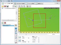 |
Figure 19 Movement of object
within the
zone |
ECO Drive plug-in
The shortest distance from vehicle to road shoulder can now be outputted on a
log. Also, during a scenario, you can place a 3D model on an arbitrary roadway
to prevent the vehicle from reaching its destination. This model cannot be seen
on main screen while scenario is being played.
In addition, the
positional relationship of each other is calculated by an easy rectangle. This
invisible model is also reflected on the log that is output.
|
| In UC-win/Road Ver.6, the various functions described above were added and
expanded. We will surely do our best for improvement to meet users' requirement.
Look out for it! |
| (Up&Coming '11 Late fall issue) |
|
Forum8.Co, Ltd. (CEO: Ito Yuji URL:http://www.forum8.co.jp)
won the award under the category Safety Initiative of the Year in the "2011 NCE International Tunnelling
Awards" with BMIA, France, on December 1st, 2011.
Safety Initiative of the Year is given to the cutting-edge and remarkable
technology which has contributed to the tunnel industry from the aspect
of safety, health and benefits to society. BMIA and Forum8 was chosen from
the 5 final candidates of this year.
This award was the fruit of G'VAL Real Time Traffic Visual Simulator (hereinafter referred to as G'VAL system) which was co-developed by BMIA and Forum8 using UC-win/Road
SDK based on UC-win/Road of Forum8.
 |
Philippe Marsaud, BMIA(Right),
Katsumi Matsuda, Forum8 (Left) at award ceremony
|
When there is a collision accident or fire in a tunnel, tunnel operators
are required to make correct decision and action quickly. They need to
give drivers in a tunnel instructions on how to escape from the tunnel
using a singal, electronic signage and at the same time call an ambulance
or a fire truck depending on the situation. It's very important to
train tunnel operators for the various types of emergency. BMIA which has
abundant experience in tunnels developed a training system based on virtual
reality by combining tunnel simulator of BMIA with UC-win/Road.
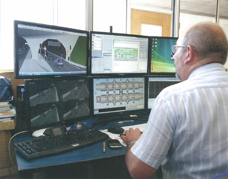 |
| Mr. Philippe Marsaud, technical manager of BMIA, operating G'Val system |
At
present, BMIA is developing software as well as consulting such as
training clients on the usage of "SCADA(Supervisory Control And Data
Acquisition)" system which administers tunnels. G'VAL
system visualizes a realistic data by SCADA and UC-win/Road through
scenarios created in the software developed by BMIA.
In the scenario there are slow cars, disabled cars, and accidents and smoke are planned to occur.
Mr.
Philippe Marsaud, technical director of BMIA, highly evaluates the
ability of UC-win/Road to work with other system by UC-win/Road
SDK.
Cost and long-term impact were also considered in choosing the winner
in the category, Safety Initiative of the Year. Judges made the following
comment.
"This system will be used in many types of important fields not only
in training for current tunnel security and operation but also for the
safety related to tunnel and it's expected to bring a big possibility to
tunnel industry's future."
G'VAL system has a wide range application in various area besides road
tunnel such as railroad tunnel, road traffic in urban area, etc. Urban
traffic manager can use it as a training for controlling of traffic lights,
lane restrictions etc. to reduce traffic jams. USA which has suffered from
the problem of traffic jams already expects this system to provide
the perfect solution. |
Seminars in Shanghai, Beijing and Seoul will be held according to the
following schedule.
Venue:
Shanghai - Shanghai Seminar room (FORUM8 Technology
Development(Shanghai) Co., Ltd)
Beijing - TBA (FORUM8
Technology Development(Beijing) Co., Ltd)
| Seminar |
Date |
City |
| VR-Studio(R) |
January 6, 2012 |
Shanghai, Beijing |
| UC-win/Road
VR |
January 13, 2012 |
| May 19, 2012 |
| UC-win/Road
DS |
February 10, 2012 |
| UC-win/Road
SDK |
February 23, 2012 |
| Traffic
analysis/ VR simulation |
March 16, 2012 |
| Govermment, Local authority/VR-Cloud(R) |
February 17, 2012 |
| May 16, 2012 |
| Dynamic
analysis/F3D |
March 13, 2012 |
| Allplan |
April 18, 2012 |
UC-1
Series
|
April 27, 2012 |
| EXODUS・SMARTFIRE |
February 28, 2012 |
| May 23, 2012 |
Engineer's Studio(R),
Engineer's
Studio(R)(2D)) |
April 11, 2012 |
Shanghai, Beijing |
| xpswmm |
May 30, 2012 |
Shanghai, Beijing |
| Design Builder |
March 22, 2012 |
Shanghai, Beijing |
| High Performance Computing on Cloud Services TM trial |
March 8, 2012 |
Shanghai, Beijing |
| Participation Fee |
| Participation Fee |
Free |
For more information and applications, please email us at
mailto:forum8@forum8.co.jp
Gross circulation: 6117
To subscribe this page, go to http://www.forum8.co.jp/english/p-mail-e.htm
If you would like to unsubscribe from our newsletters, please include "Unsubscribe"
in the subject title of your email and send it back to us.
Thank you for your continued support.
FORUM8 Co., Ltd. mailto:forum8@forum8.co.jp
Nakameguro GT Tower 15F
2-1-1 Kamimeguro Meguro-ku Tokyo 153-0051 JAPAN
TEL +81-3-5773-1888
FAX +81-3-5720-5688
http://www.forum8.com/ |
|


