
Plugin option for UC-win/Road to link with S-PARAMICS, a leading traffic microsimulation software
S-PARAMICS Plugin
Initial Release : 2010.04.08
- USD800
Related Product: UC-win/Road
Micro Simulation Player Plugin Option
Program Overview
S-PARAMICS Plugin Option enables data exchange between UC-win/Road and S-PARAMICS to provide a great combination of traffic analysis and 3D virtual reality by linking one of the leading traffic microsimulation solutions with UC-win/Road.
Here, we introduce the road network exchange function.
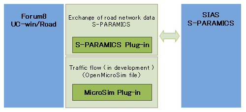
Functions and Features
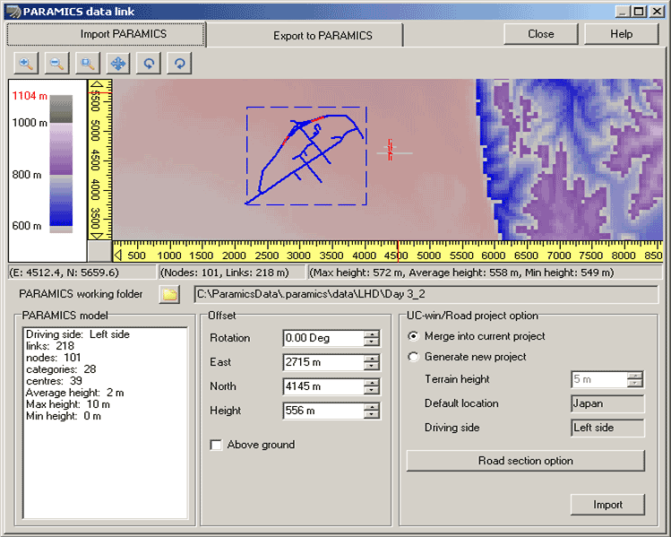
S-PARAMICS and UC-win/Road can share the same road network information by exchanging geometric data of the road.
S-PARAMICS/OpenMicroSim Conversion Tool (under development) enables you to visualize the simulation result of S-PARAMICS, and the S-PARAMICS plug-in can then be used to maintain the positions of the vehicles and the roads.
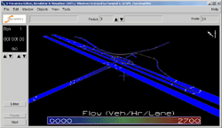
Virtual reality environment of UC-win/Road can be used to visualize landscapes, road designs and traffic as well as to check road conditions from the driver's viewpoint on our state-of-the-art Drive Simulator. In addition, this plug-in option can be used for high quality traffic simulation.
The amount of work can be greatly reduced by converting the road network data created in UC-win/Road and using it in S_PARAMICS for simulation. We envisage that the reciprocal data exchange between VR and traffic analysis will create an ideal combination between the comprehensive visualization and the state-of-the-art technology to help improve the road conditions and the traffic.
Data Exchange Function
-
- Positions of link points(3D)
- Connection point information
- On-ramp information
- Road alignment: straight line, arched
- Slip-ramp information
- Section property: number of carriageways, lane width, type (Urban/Highway)
- Road alignment and geometric data for longitudinal alignment
- Basic setting of intersections (ordinary /rotary)
- On-ramp generation
- Road alignment: import as straight line, arched
- Off-ramp generation
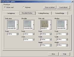
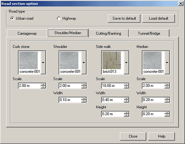
- Number of carriageways, lane width, texture assignment + initial settings of fills, cuttings and sidewalks
- Changes in road geometry: number of carriageways, lane width, change in road alignment and longitudinal alignment, ramps, intersections
- Road alignment: straight line, arched
- Relaxation curve(Clothoid)
- Cross section: number of carriageways, lane width
- To export an area with no changes as one link, nodes are created and ramps are set up.
- Export as ordinary Links and Centres
- Split and exported as straight line links
- Cross sectional property: number of carriageways, lane width export as urban.
Due to the difference in data format for road networks in traffic simulation and in Virtual Reality, data conversion is required. S-PARAMICS does not require as much information about roads for simulating traffic as UC-win/Road does. Therefore, it is more practical to carry out detailed settings on the road after the data is imported into UC-win/Road from S-PARAMICS. On the other hand, detailed traffic settings, including connection points, must be carried out after importing data from UC-win/Road to S-PARAMICs. This plug-in option is design to minimize the work load by exchanging data. Details of data exchange are described below.
▼ S-PARAMICS data import and export specifications S-PARAMICS file Nodes:
Links+Centres:
Categories:

UC-win/Road object Road+Intersection:
Road:
Cross section:
▼ S-PARAMICS data export specifications UC-win/Road object Road:
Road alignment:
Cross section geometry:
S-PARAMICS file Nodes:
Links+Centres:
Categories:
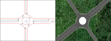
■ A roundabout imported from S-PARAMICS
Node with attributes for roundabout is represented in UC-win/Road. It also shows the alteration in cross section on the right hand side of the intersection.
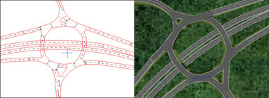
■ A complex roundabout with multiple intersections imported from S-PARAMICS
In S-PARAMICS, roundabouts are often set up with multiple connections, and in UC-win/Road, they are represented as series of intersections.
Since the height data is added the original data, UC-win/Road enables you to set the longitudinal alignment.
Roads passing below the roundabouts are automatically set as tunnels.
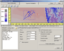
User Interface
-
The data to be imported can be viewed easily. The parameters for import and the textures of the cross section can also be chosen.
Sample
-
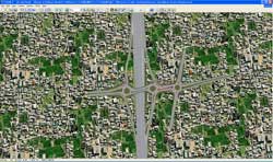
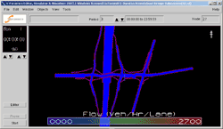
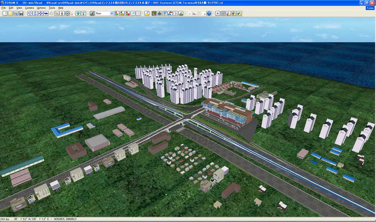
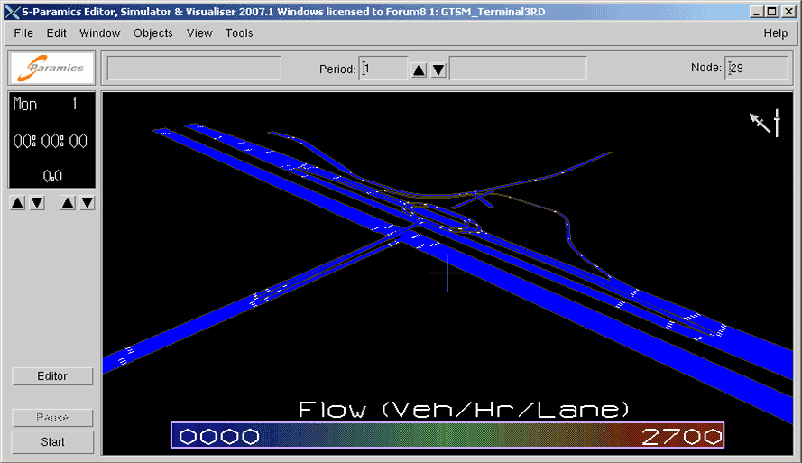
■The 9th 3D VR Simulation Contest data, "Transfer VR simulation at Junjon Service Area in Korea", GTSM Inc. (Korea) converted into S-PARAMICS data.

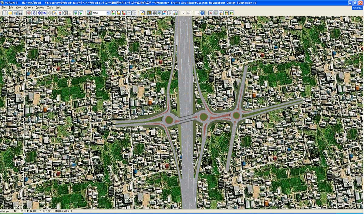
■The 9th 3D VR Simulation Contest data, "VR Data of Roundabouts in US 41 Project", Ourston Roundabout Engineering, Inc.(USA), converted into S-PARAMICS data.

What is S-PARAMICS or who is SIAS?
>> Collaboration News: SIAS Limited, U.K.
SIAS has been providing expertise and technologies concerning a wide range of issues related to transport planning for more than 30 years. Its main clients are central and local governments, their agencies, and private sector developers. SIAS was the first company in the UK to adopt microsimulation, developing its own software for the market
SIAS was set up in Edinburgh, the capital of Scotland in 1974, as a branch office to perform transport-planning consultancy. SIAS was using CDC6600, then the highest performance computer available in Europe. In 1988, the current organization was formed. Since then, SIAS opened offices in Perth and Glasgow in Scotland, and London and Birmingham in England. In 1990s, OBE(Order of the British Empire) was given to its managing director for SIAS’S long contribution to develop traffic simulation and planning method.
The Company's core activity is transport planning. SIAS's Paramics Microsimulation division has developed a widely applicable traffic flow modeling system in response to the demand of transport planning markets in the world over. S-Paramics is the latest version of the software for the analysis and design of such urban and highway networks. S-Paramics offers wide area modeling with high accuracy, such as tiered dynamic route choice for robust routing in large networks, with links to ITS and UTC systems. S-Paramics can also model transit operations with user defined scheduling and bus stop loading.
S-Paramics is highly respected by traffic planners and modelers throughout the world as the most versatile and comprehensive road traffic flow analysis system. The traffic flow analysis includes road planning evaluation proposed by Scotland Transport Authority and NESA ("Network Evaluation from Surveys and Assignment” which was developed to estimate the impact on traffic and economic activities. NESA was first introduced in 1978, has become an important tool to evaluate the transportation by Scotland Transport authority and the economy today.
Price
Product Price
-
Click here for the price of UC-win/Road
■Product Price
Product
Product Configuration
Price
UC-win/Road Ultimate UC-win/Road
+
including all pluginsUSD17,200 UC-win/Road Advanced UC-win/Road
+
Micro Simulation Player
Plugin Option
and other pluginsUSD8,800 Micro Simulation Player
Plugin OptionPlugin only USD3,360 Micro Simulation Player
S-PARAMICS PluginPlugin only USD800 ■Price of Floating License
Paying 40% of the product price allows anyone to use the product on any PC anywhere in the world.
Product
Price
UC-win/Road Ultimate USD6,880 UC-win/Road Advanced USD3,520 Micro Simulation Player
Plugin OptionUSD1,344 Micro Simulation Player
S-PARAMICS PluginUSD320
Price of Subscription Service Contract
Price of Subscription Service Contract
-
■Support information
-Software upgrade -Technical inquiry (Email, Tel)
-Download service -Maintenance and update notifications via email
* We are sequentially making a transition from the maintenance-support service to [Subscription Service] from April 1, 2016 in order to enhance support for diverse product usage and to reduce license management cost.
Product Subscription cost
of first yearSubscription cost
of subsequent years
(annual cost)Subscription
(Micro Simulation Player S-PARAMICS Plugin)Free USD320 Subscription
(Micro Simulation Player S-PARAMICS Plugin Floating)USD448
Price of Rental License / Floating License
■Rental license : Short term licenses available at a low price
■Rental floating license : After web activation, anyone can use the products on any PC anywhere in the world.
■Rental access : You can increase the number of licenses you own and use these additional licenses for a specific period of time (2 month to 3 month) at your discretion. We will later send you an invoice based on your usage log. The advance application is 15% off of the regular rental license price. Please place an order from User information page.
*Rental / Floating Licenses were introduced on September 2007 to enhance user experience and convenience of our products.
*Duration of Rental / Floating Licenses cannot be changed after starting these services. Re-application is required to extend the rental and floating license duration.
Rental license / Rental floating license
-
■Rental License
Product 2 month 3 month 6 month Micro Simulation Player S-PARAMICS Plugin USD408 USD480 USD592 ■Rental Floating License
Product 2 month 3 month 6 month Micro Simulation Player S-PARAMICS Plugin USD688 USD816 USD1,008 Order / Contact Us
Order / Contact Us
-
Inquiries about UC-win/Road: road@forum8.co.jp
Order
Contact us from Sales inquiry or email to ist@forum8.co.jp


LOADING