UC-win/Road UC-win/Road Support System UC-win/Road UC-win/Road Support System
|
 |
|
|
| ( The following pictures use UC-win/Road
Ver.3.1 new function "POV-Ray Option."
) |
 |
 |
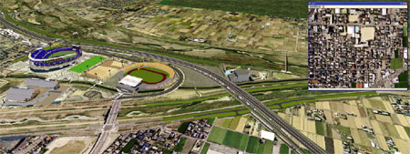
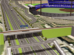
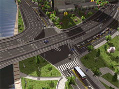
| Matsuyama belt highway
|
Ministry of Land, Infrastructure and
Transport, Shikoku Regional Development Bureau,
Matsuyama Rivers and National Highway Bureau |
|
Content :
For the Matsuyama belt highway project, the main road, three ramps, one
JCT, survey road and several intersections are represented. A part of
the surrounding roads and streets were also created. The first local
produce placed as landmark is the Botchan stadium, some building are
also placed around the intersection.
In addition of being used for explanation purposes for the citizens,
these data will be used for the presentation new driving simulation
system |
|
|
 |
China : Tientsin Haihe bridges project
- Cifeng bridge design study
|
| CRISEN TECHNOLOGY CO., LTD. |
|
Content :
Tientsin is a city of the North-East part of the plain of North China,
facing the sea and Bohai at the East side of the bay. It is the bigest
open shore of the North China and the economical center of Huanbohai
area.
Haihe is the origin and the image of Tientsin and will welcome the 2008
Olympic Games. The restructuring project of Haihe is therefore and
important part of the development strategy of Tientsin.
The Cifeng bridge is at the heart of the development of Haihe and at
the center of the financial and business district of Tientsin. Next to
Tientsin station and East hand of the Cifeng road of Heping district
and Haihe West road, it links the Ligonglou interchange of Hedong
district at the East side. Since one road extends over Heping and
Hedong districts, it becomes the major link between the South-East part
of the city and the Binhai internatinal airport.
Up to now, future developments for the Cifeng bridge have always been
delayed. Because its capacity is limited with the 10m wide structure
and one way two lanes traffic, peak hours see outbreak of chaotic
congestions. Even the separation of the up and downstream circulation
in two bridges (Daguangmin for the downstream) cannot restrain the
traffic disorder.
The purposes of the project are as follow :
- Bridge design plan
 Situation, traffic and especialy congestion
situation. Situation, traffic and especialy congestion
situation.
- Passing method plan |
 |
 |
|
|
 |
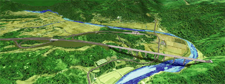
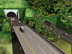
Korea : Dong Hong Cheun - Yang Yang highway project.
|
Korea Highway
Corporation Basis Soft,Inc |
|
Content :
These data represent the junction between Seoul and Yang Yang:
Seoul-Chun Cheun (61km under work), Chun Cheun-Dong Hong Cheun (17.5km
under work), Dong Hong Cheun-Yang Yang (71.5km design).
Aproximately half the complete length is modelized in UC-win/Road. The
first Korean highway modelized with computer graphics in Korea.
Project goals :
The contribution to a good land development with the East-West junction
of the Kangwon and capital's area is the main goal of the overwhole
project. Because of its respect of the natural beauty of the landscape
between Dong Hong Cheun and Yang Yang this junction is refered as the
"New Environmental Highway". Construction methods that minimize the
environmental destruction, bridges and tunnels (with the longest tunnel
of Korea : 10.9km) that take in consideration the harmony of the
scenery... various design techniques are introduced for this highway.
Simulation purposes :
- Study the alignments to reduce environmental destruction.
- Study of the positioning for ecological service areas.
- Study of the design of surrounding scenery and beautiful sight
preserving bridges and tunnel.
- Study of the design of noise barriers and retaining walls.
- Explanation to the inhabitants and environmental associations. |
 |
 |
|
|
 |
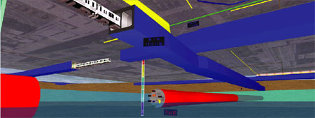
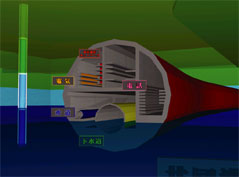
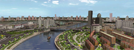
Metropolitan underground infrastructure model
|
|
Representation with several points of
view of structures of an underground space (subway, underground
facilities). Data used for explanation to the citizens.
Content :
Creation of a metropolitan underground of the vicinity of a subway
station, including water supply and sewage pipes, gas pipes, and a
complex representation of the subway.
Representation of the different soil layers with gradation plans and a
depth gauge. The use of the fog in the underground increase the reality
of the model. |
|
|