UC-win/Road Ver.13.0.0 (Released on February 5, 2018)
 |
|
|
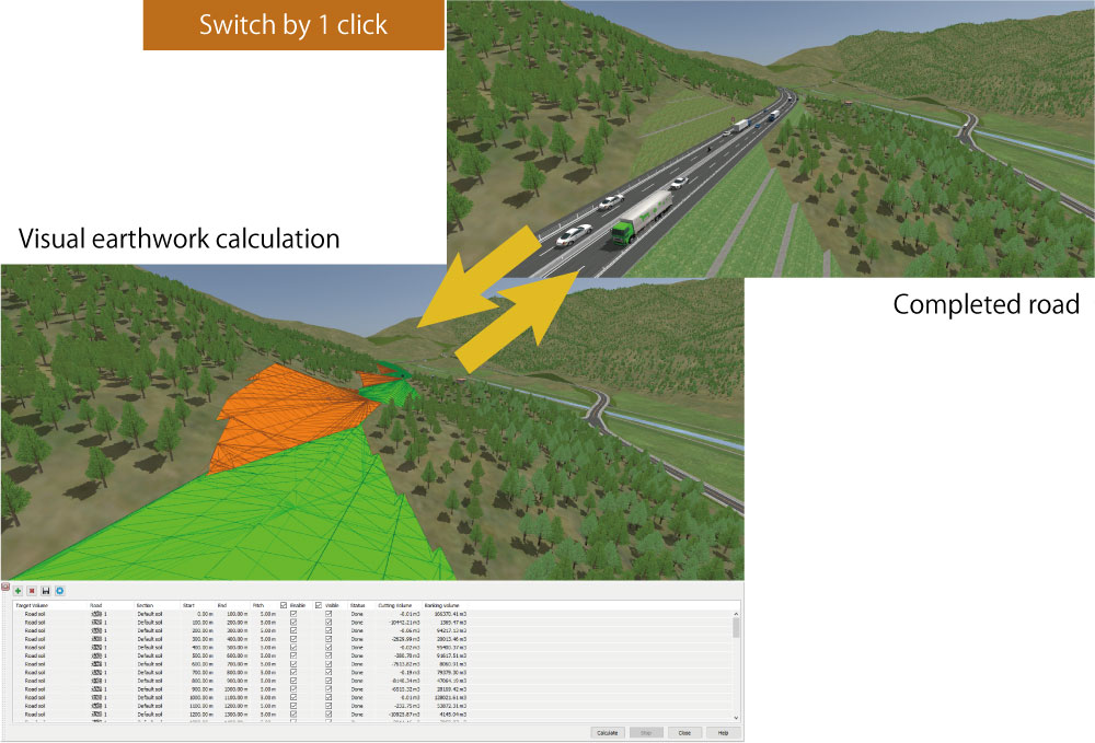
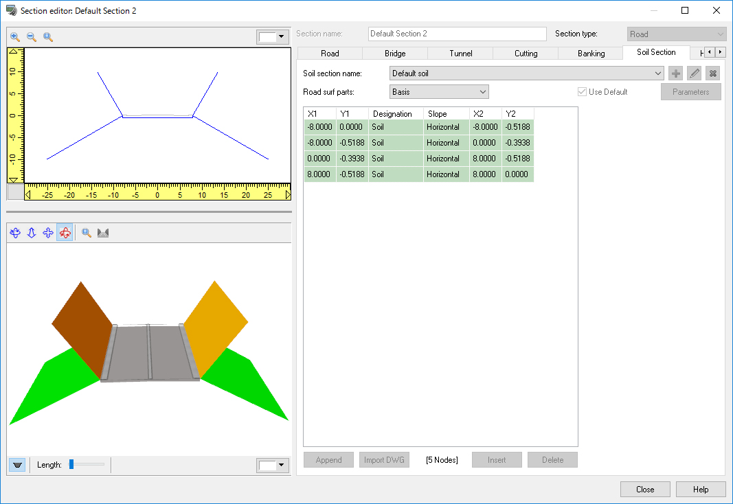
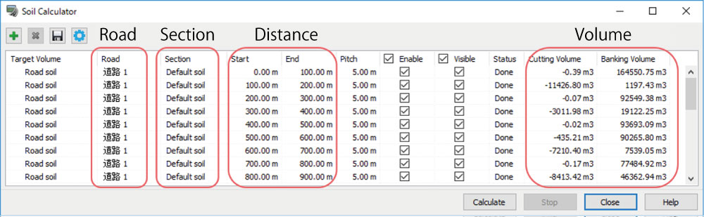
Earthwork Volume Calculation |
|
- The volume of banking and cutting can be calculated from terrain and civil
engineering cross section.
The cross section used for the calculation is automatically generated by default, and the calculation case from starting point to ending point of the roads in the project is defined. In addition, it is possible to define the earthwork cross section that users input and the calculation cases with sections set. Users can also use the functions to display the civil engineering surface used for the calculation on the main screen and to export the calculation result in the CSV format.
 |
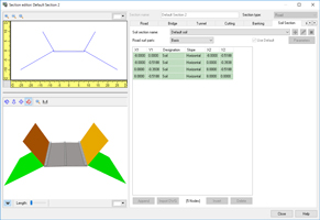 |
| Earthwork volume calculation |
Section editor |
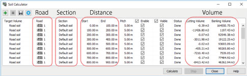 |
| Soil calculation setting |
A function to create and edit polygonal zones on the terrain has been added.
Users can create zones by clicking on the terrain and selecting the area
around it. In addition to modifying, the following operations can be conducted
to the created zone.
- Name the zone
- Confirm the elevation and area in the zone
- Create buildings in the zone
- Create forests in the zone
The menu to call the quick building function has been deleted because the
building creation function above now includes this function.
|
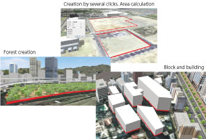 |
| Utilization of the zone function |
|
- Options to play sounds in scripts and scenarios on other audio devices have been added to the Audio Setting.
The sound expression of rain has been added.
|
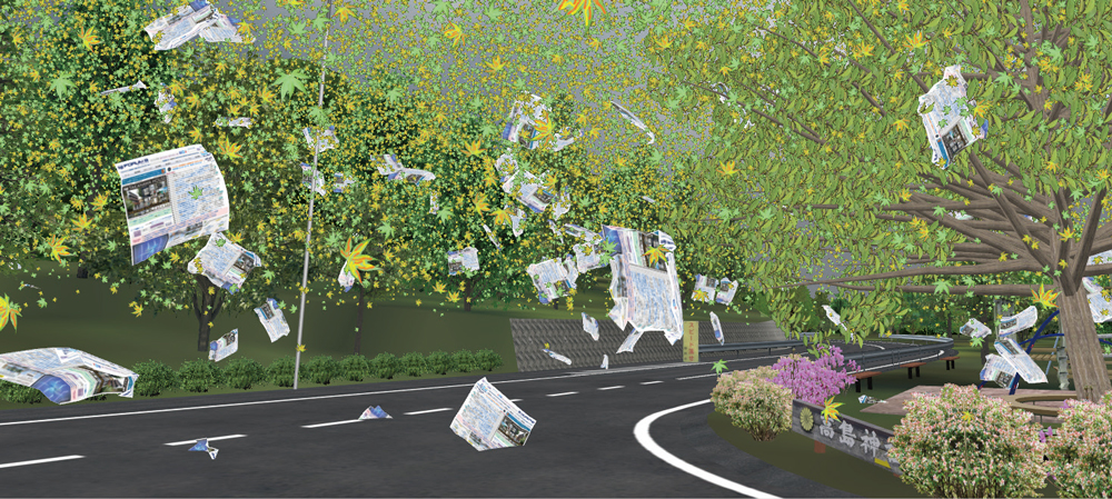
Fluttering leaves and clothes |
|
- Scenes that include wind-blown dust, including leaves and clothes can now be rendered.
It is available from [Wind] tab in the Visual Options.
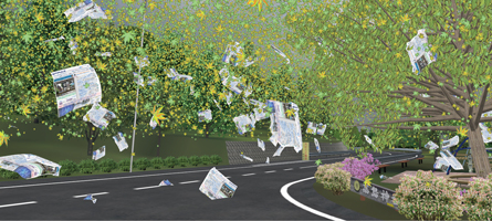 |
| Weather expression |
- The plug-in now supports the controller device. The model you set is shown
on the display and the viewpoint moves according to the motion of the controller.
 |
| VIVE plug-in operation menu |
- Users can now manually record passing points by remote controller.
The simulation mode has been added. In this mode, users can practice the manual flight and test the flight plans without using actual drones.
- Users can now control the clients' viewpoint position data and the setting data of the camera sensor plug-in.
|
UC-win/Road Ver.13.1.0 (Released on November 19, 2018)
|
|
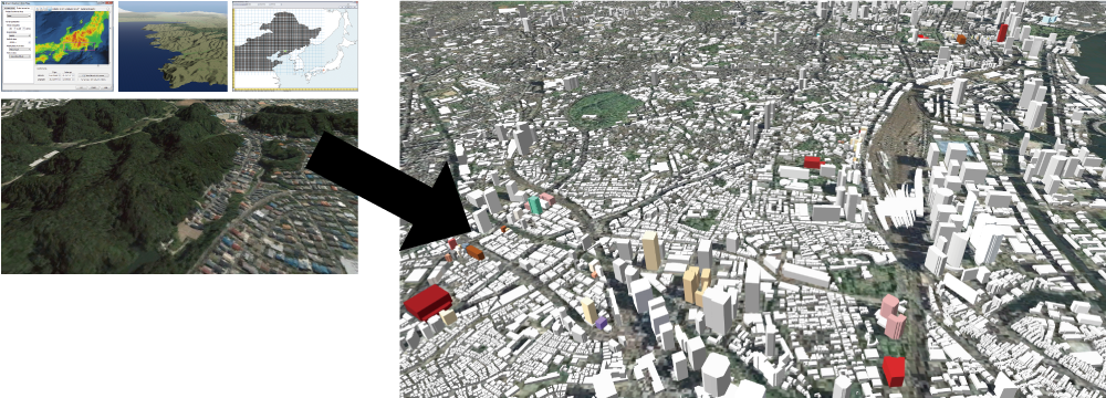
●Import of online map data
Enhancement of plug-in options
The import of OpenStreetMap and the GIS map helps the easy creation of
building and forest.
●Improved precision of conversion between latitude/longitude and right-angled
coordinate
More accurate data can be created by using coordinate data of project data
and converting latitude and longitude from the coordinate in high precision.
●Improvement of Point Cloud Modeling Plug-in
Point clouds can be displayed in LOD now for more comfortable and efficient
usage of hundreds of millions of point clouds data.
●Model integration
This function reduces the memory consumption during operation and the size
of project files. The improvement of the usability of project operation
can be expected.
●Parallel processing of road model creation
A parallel processing to accelerate the processing of 3D road shape creation.
This processing reduces the time of road edit as well as the time for opening
data.
●Improvement of driving algorithm for traffic flow
A traffic algorithm with improved calculation of steering amount to keep
lane is implemented. This improved the function to follow a vehicle in
traffic compared to the previous version product.
●Civil 3D Plug-in
Corresponds to Civil 3D 2018.
●Assessment Plug-in Option
Decrease in working memory and project file memory improves the usability
in project operation.
●D-BOX Plug-in
UC-win/Road can be cooperated with D-BOX, the vibration device made by
BMIA. This motion system can be freely built with 1 to 7 actuators. In
addition to 6DOF for vehicle, it can be used for certain vibration of seat,
road surface, etc.
●FOVE Plug-in
Plug-in for the cooperation between a Head Mounted Display "FOVE 0"
sold by FOVE Inc. and UC-win/Road. |
|
 |
Left: 50m mesh GIS numerical map and satellite photo can be imported.
Right: Ver.13.1 can import buildings on OpenStreetMap |
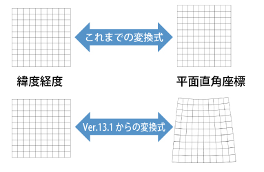 |
Converting longitude and latitude
and plane right angle coordinate system |
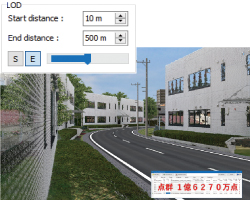 |
| Point cloud with 162,700,000 points |
|
|
|